This copy is copyright protected.
Copyright © 2025 Geographicus Rare Antique Maps
Digital Image: 1884 Loureiro Map of Hong Kong, Macau, and Guangdon (Canton) Province
HongKongMacao-loureiro-1884_d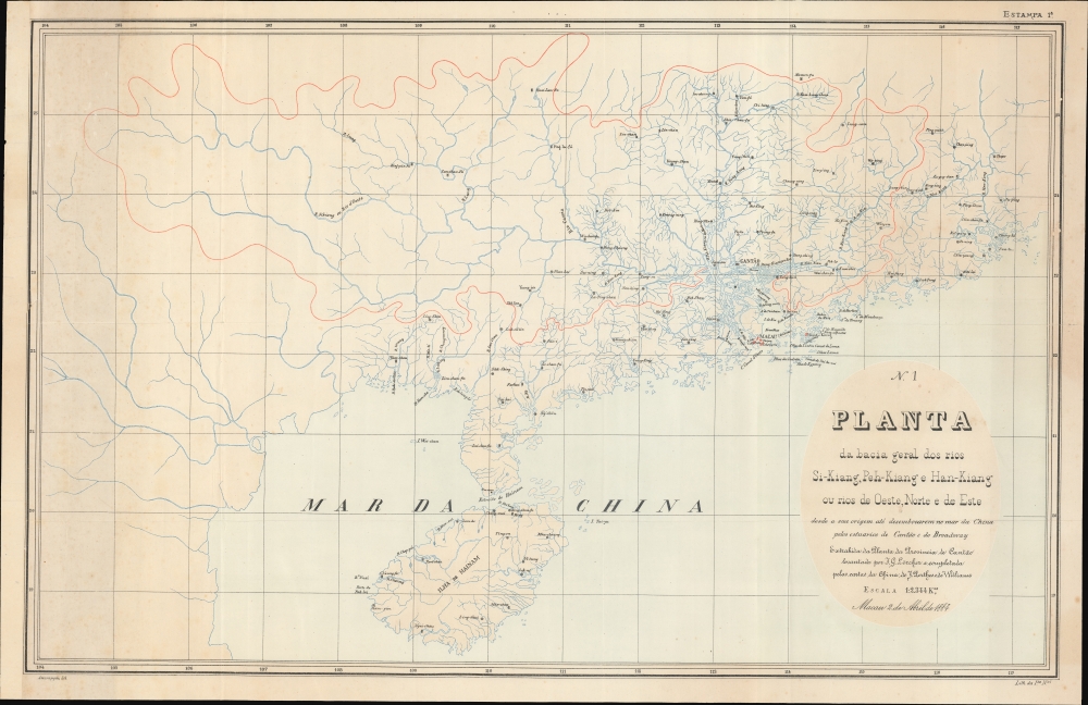

FOR THE ORIGINAL ANTIQUE MAP, WITH HISTORICAL ANALYSIS, CLICK HERE.
Digital Map Information
Geographicus maintains an archive of high-resolution rare map scans. We scan our maps at 300 DPI or higher, with newer images being 600 DPI, (either TIFF or JPEG, depending on when the scan was done) which is most cases in suitable for enlargement and printing.
Delivery
Once you purchase our digital scan service, you will receive a download link via email - usually within seconds. Digital orders are delivered as ZIP files, an industry standard file compression protocol that any computer should be able to unpack. Some of our files are very large, and can take some time to download. Most files are saved into your computer's 'Downloads' folder. All delivery is electronic. No physical product is shipped.
Credit and Scope of Use
You can use your digial image any way you want! Our digital images are unrestricted by copyright and can be used, modified, and published freely. The textual description that accompanies the original antique map is not included in the sale of digital images and remains protected by copyright. That said, we put significant care and effort into scanning and editing these maps, and we’d appreciate a credit when possible. Should you wish to credit us, please use the following credit line:
Courtesy of Geographicus Rare Antique Maps (http://www.geographicus.com).
How Large Can I Print?
In general, at 300 DPI, you should at least be able to double the size of the actual image, more so with our 600 DPI images. So, if the original was 10 x 12 inches, you can print at 20 x 24 inches, without quality loss. If your display requirements can accommodate some loss in image quality, you can make it even larger. That being said, no quality of scan will allow you to blow up at 10 x 12 inch map to wall size without significant quality loss. For more information, it is best consult a printer or reprographics specialist.
Refunds
If the high resolution image you ordered is unavailable, we will fully refund your purchase. Otherwise, digital images scans are a service, not a tangible product, and cannot be returned or refunded once the download link is used.
Adolfo Ferreira Loureiro (December 12, 1836 - November 22, 1911) was a Portuguese soldier, engineer, writer, poet, and politician. Loureiro was born in São Bartolomeu, Coimbra, Portugal. He studied mathematics and civil engineering at the University of Coimbra and entered the military in 1858. In 1883, he traveled to British India, Ceylon, Singapore, China, and Macau. In Macao, he accepted a commission as Captain of Engineering and Major of the General Staff, working on desilting the port of Macao. At the same time, he became involved in politics and was elected in 1890 as 'Deputado' to the 1.° Círculo Eleitoral de Macau. A prolific writer, he penned more than 24 works, but is best known for his travel narrative, De Nápoles à China (diário de viagem) (Lisboa: Imprensa Nacional, 1896). Loureiro returned to Portugal where he had a distinguished engineering and academic career. He even curated and built an extensive historical collection of arms and armaments, which were donated to a museum. He was vice-president of the Lisbon Geographic Society, and was also president of the Geodesy section. He was president of the Almeida Garrett Literary Society. Member of the Academia de Ciencias de Portugal. More by this mapmaker...
António José Saldanha Assumpção (1850 - 1900) was a Portuguese lithographer active the late 19th century. His birth and death dates are those given by the Biblioteca Nacional de Portugal, but we can find little confirmation or other information about this printer. He published several well-made chromolithograph maps of Portuguese colonies in Africa and Asia. Learn More...
Imprensa da Universidade de Coimbra (1537 - Present) is a Portuguese academic publisher associated with the University of Coimbra. Founded in 1537, just seven years after the introduction of the printing press into Portugal, it is one of the longest continuously running publishing concerns in the world. Printers where granted academic status as 'professors' and the Imprensa was required to provide two copies of all books printed to the University Library. In addition to official and university publications, as the only press in Coimbra, the Imprensa also took private contract work. It remains an active part of the Universidade de Coimbra. Learn More...
Copyright © 2025 Geographicus Rare Antique Maps | Geographicus Rare Antique Maps
This copy is copyright protected.
Copyright © 2025 Geographicus Rare Antique Maps