This item has been sold, but you can get on the Waitlist to be notified if another example becomes available, or purchase a digital scan.
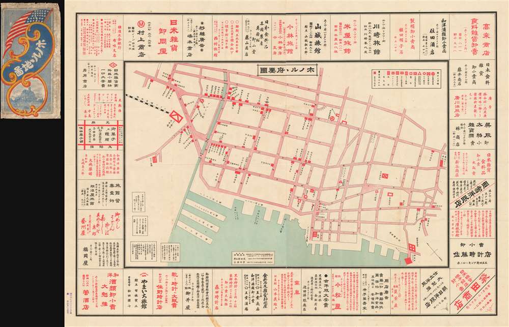
1906 Takei Nekketsu Map of Japantown, Honolulu, Hawaii
HonoluluJapantown-takei-1906
Title
1906 (dated) 30 x 40 in (76.2 x 101.6 cm)
Description
Japanese Immigration to Hawaii
Japanese exchange with Hawaii dates to the early 19th century when, in 1806, when the survivors of the ill-fated Japanese cargo ship Inawaka-maru, were stranded on the archipelago. These survivors were treated well by the king, leading to an official Hawaiian delegation to Japan in 1866. The first Japanese immigrants to Hawaii, the 142 men and 6 women, known as the Gannenmono (元年者) arrived to years later in 1868 (Meiji I). These first Japanese immigrants were brought to Hawaii as low-cost labor to work sugar plantations. Following mistreatments associated with the sugar plantations, the Emperor banned further immigration to Hawaii until 1885. In that year, a second wave of 153 Japanese immigrants arrived, also to indentured to work sugarcane and pineapple plantations. Further immigration followed, with about 900 total immigrants arriving in 1885 alone. Nearly 30,000 followed in the subsequent years. Many returned to Japan when their three-year plantation contracts expired, but some stayed, becoming known as the Issei, the first generation. Their children, born in Hawaii, were consequently known as the Nisei.Brought to Hawaii as indentured plantation workers, the Japanese immigrants to Hawaii were generally ill-treated as second-class citizens. They nonetheless maintained their Japanese language, religion, and traditions, often preferring to bring marriage partners from Japan rather than wed locals. Thus, a large and mostly homogenous Japanese community emerged, with their own businesses, neighborhoods, hospitals, and schools. This large Japanese population was one of the regions the Japanese Empire during World War II set their sights on Hawaii. Today, Japanese culture remains a vibrant part of Hawaii culture and Japanese Hawaiians make up the second largest ethnic group in Hawaii.
Publication History and Census
This is one of two large format maps apparently issued by the same publisher in Hawaii. The present example focuses on the Japantown or Japanese district of Honolulu, and the second on the Hawaiian islands in general (see Geographicus: HawaiiShopping-japanese-1906). The map was prepared by Takei Nekketse (武居熱血) in Hawaii, but printed in Tokyo, Japan. It printed on Printed February 20, 1906 and released on March 1 of the same year.We have identified no other surviving examples of this rare and important cartographic documentation of early Japanese life and settlement in Honolulu. Important and rare.
Cartographer
Takei Nekketsu (March 8, 1879 - April 22, 1961) (武居熱血) was a Japanese-Hawaiian merchant, photographer, editor, journalist, patent attorney, storyteller, and map maker based in Honolulu, Hawaii. Takei was born in Kudamatsu-shi, Yamaguchi-ken, Japan, the eldest son of a Sake manufacturer. Hailed as a child genius, he studied Chinese under Manumoto Sakyo at the Shoryu Temple, then at the Tokuyama Middle School. After the Sino Japanese War (1894 - 1895), Takei became fascinating with political and military events and began lecturing throughout Japan. Seeking greener pastures, he emigrated to Honolulu, Hawaii, arriving on December 15, 1903. With most Japanese in Hawaii at the time being poor uneducated cane farmers, the dashing, sophisticated, and highly educated Takei stood out, with trademark long hair, a large well-groomed mustache and beard, a black bower hat, and a frock coat. He continued lecturing among the Japanese diaspora in Hawaii, publicly asking such questions as 'Should Japan fight Russia?' and following up with 'This is the Way the Japanese Fought the Russians.' From about 1915, he owned a Kimono and dry goods shop, Takei Dry Goods, on the corner of River and Pauahi Streets, and later at 1319 Beretania St., then at 1423 S. King Street. During World War II he was briefly interred in California. Takei was well known to Hawaiian Japanese, among whom he traveled as a traditional storyteller and edgy political lecturer. While walking between plantations and Japanese-Hawaiian communities, he also produced uniquely historic documentary records of Japanese life in Hawaii through photographs and maps. These he compiled and published, often in Japan, emerging as the most prolific Hawaiian-Japanese writer of his time. When the first radio station KGU, launched Japanese programing, he signed up to tell his stories over the radio, a hobby he pursued for more than 10 years. He lived at 1414 Pickoe St., Honolulu and was a member of the Tenshō Kōtai Jingūkyō. More by this mapmaker...

