This item has been sold, but you can get on the Waitlist to be notified if another example becomes available, or purchase a digital scan.
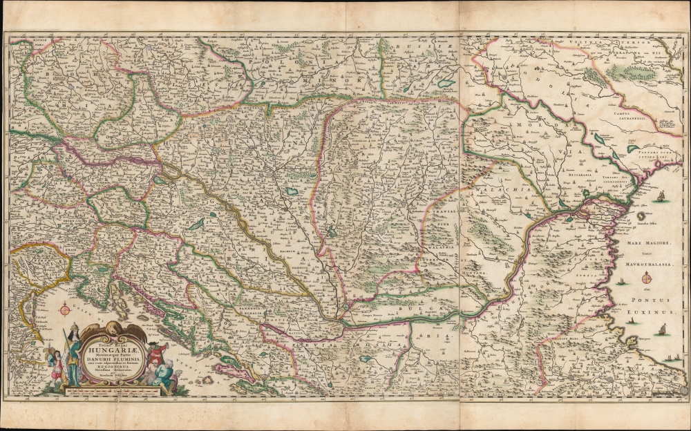
1658 Nicolas Visscher map of Hungary and the Danube
Hungary-visscher-1658
Title
1658 (undated) 17 x 31.5 in (43.18 x 80.01 cm) 1 : 2200000
Description
The Scope of the Map
Tracing the course of the Danube, the map encloses Austria, Transylvania, Sclavonia, Croatia, Bosnia, Serbia, and Dalmatia. Portions of Austria, Greece, and Italy appear as well. Vienna, Buda and Pest, Belgrade, and Constantinople are among the major cities appearing here. Throughout, many cities and towns are marked with either a cross or a crescent, indicating their affiliation with the Christian West or the Muslim Ottoman Empire.Foreshadowing
Although the map was produced prior to what would enfold into over thirty years of war, there is little question here that war would, or should, occur. The cartouche is flanked with allegorical figures: to the right (east), turbaned figures are chained in bondage. To the west, Emperor Leopold I (as King of Hungary) looks sadly upon the chained unfortunates. He carries a naked sword, but he is still crowned: a page stands ready with the Emperor's helmet. By 1663, war between the two empires would be well underway.The Standard Seat of War Map
Visscher's map formed the template for the mapping of the ongoing conflict along the Danube. Its superiority is attested to by the frequency with which it was copied over the course of the next 30 years. In 1665, Wilhem Serlin re-engraved it for his Diarium Europaeum, to illustrate the events of the 1663-4 Austro-Turkish war. It was also copied by Carel Allard c. 1685 to celebrate the 1683 repulse of the Turkish from Vienna. Visscher's son Nicolas II reworked the plate in 1687, with a different title and cartouche, bringing the map up to date for the Great Turkish War (1683 - 1699).Publication History and Census
This map was engraved to two plates by Nicolas Visscher I as early as 1658. We see it in its separate sheets in a composite atlas held in the University of Leiden, dated 1660 and bearing other Visscher maps of the 1658 vintage. It remained in the Visscher atlases unchanged until Nicolas II reworked the plate in 1687. In its various states, the map is well represented in institutional collections.Cartographer
Nicholas Visscher I (1618 - 1679) was a Dutch engraver, cartographer and publisher. The son of Claes Jansz Visscher (1587 - 1652), he was brought up in and carried on the family publishing firm after his father's death. During his tenurem, the firm produced an array of maps that introduced a new level of artistic flourish to the Dutch mapmaking trade: the 'Jansson-Visscher' map of the New Netherlands and New Engand provided the model map for that region for over a century, and his 1658 world map was hailed by Shirley as the 'master forerunner of a number of highly decorative Dutch world maps produced throughout the remainder of the century.' He received a privilege from Holland and West Friesland in 1677; after his death the firm was taken up by his son, Nicholas II (1649 - 1702). Upon the death of Nicholas Visscher II, the business was carried on by the widowed Elizabeth Verseyl Visscher (16?? - 1726). After her death, the firm and all of its plates was liquidated to Peter Schenk. More by this mapmaker...


