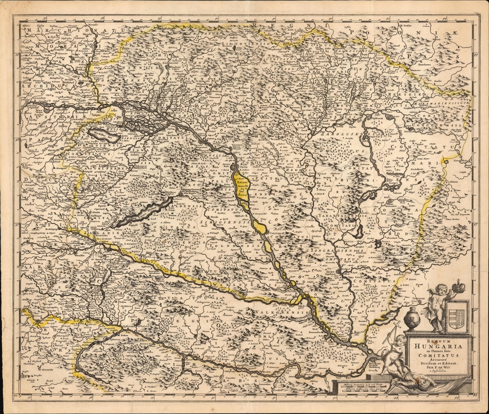
This is a c. 1688 Frederic De Wit map of Hungary and the surrounding region, including parts of modern-day Austria, Slovakia, Croatia, and Serbia. The map was issued at the height of the Great Turkish War (1683 - 1699), which ravaged the region, but a string of European victories ended Ottoman expansion into Europe.
A Closer Look
Spanning from Vienna (top-left) to Belgrade (bottom-right), the Danube River immediately commands this map. Buda and Pest are illustrated, along with numerous other towns and villages along the river and throughout the region. Mountains and trees are illustrated pictorially. The map's detail shows a sharp increase compared to the maps produced by the French and Dutch of the mid-17th century, reflecting the rise in interest in and data from this area during the Great Turkish War. The sharp detail of the south-north route between the rivers Sava Drava and the Danube leading to Vienna is less apparent, for example, on the 1677 Nicolas Visscher map covering this region. That said, De Wit's sources are obscure, a pity, as De Wit's map proved influential, being copied by the younger Visscher and other mapmakers, including Senex.
The map is embellished with an allegorical cartouche in the lower right. One putto holds an imperial crown over the arms of the Kingdom of Hungary. To the left of the cartouche, a cheerful putto brandishes a sword and a Cross while treading upon a fallen putto in Turkish garb. This unsubtle, triumphal image likely refers to the 1683 Battle of Vienna, a victory by the Christian coalition over the Turkish Empire.Historical Context: The Great Turkish War
The Great Turkish War (1683-1699), also known as the War of the Holy League, was a pivotal conflict between the Ottoman Empire and a coalition of European powers united under the Holy League, formed by the Papacy. The war began after the Ottoman siege of Vienna in 1683, where Ottoman forces, led by Grand Vizier Kara Mustafa, were decisively defeated by a combined army of the Holy Roman Empire, Poland-Lithuania, and other European allies under the command of Polish King John III Sobieski. This defeat marked the turning point of Ottoman expansion into Europe. The war saw a series of major battles across Central and Eastern Europe, involving Austria, Poland, Venice, and Russia against the Ottomans. Key events included the liberation of Hungary and Transylvania from Ottoman rule, as well as the Venetian recapture of parts of the Peloponnese. The conflict culminated in the Treaty of Karlowitz in 1699, which significantly curtailed Ottoman territorial control in Europe. Austria gained Hungary and Transylvania, Poland recovered Podolia, Venice gained territories in Greece and Dalmatia, and Russia secured Azov. The Great Turkish War marked the beginning of the Ottoman Empire's territorial decline and a shift in the balance of power in Eastern Europe, solidifying Habsburg dominance in Central Europe while weakening Ottoman influence in the Balkans.Publication History and Census
This map was created for inclusion in Frederick de Wit's Atlas. We see dates for it in institutional collections as early as 1659, but these reflect the dates of the composite atlases in which the map had been inserted, likely much later. Given the content of the map relevant to the early part of the 1680s, we support a date no later than 1688. The map is well represented in institutional collections.
Cartographer
Frederik de Wit (1629 - 1706) was a Dutch Golden Age cartographer active in the second half of the 17th and the early 18th centuries. De Wit was born of middle class Protestant stock in the western Netherlandish town of Gouda. He relocated to Amsterdam sometime before 1648, where he worked under Willem Blaeu. His first attributed engraved map, a plan of Haarlem for Antonius Sanderus' Flandria Illustrata, was issued around this time. He struck out on his own in 1654. The first chart that De Wit personally both drew and engraved was most likely his 1659 map of Denmark, REGNI DANIÆ Accuratissima delineatio Perfeckte Kaerte van ‘t CONJNCKRYCK DENEMARCKEN. His great wall map of the world and most famous work, Nova Totius Terrarum Orbis Tabula appeared one year later. Following the publication of his wall map De Wit quickly rose in prominence as a both cartographer and engraver. He married Maria van der Way in 1661 and through her became a citizen of Amsterdam in 1662. Around this time he also published his first major atlas, a composite production ranging in size from 17 to over 150 maps and charts. Other atlases and individual maps followed. In 1689 De Wit was granted a 15 year Privilege by the Dutch States General. (An early copyright that protected the recipient's rights to print and publish.) He was recognized with the honorific 'Good Citizen' in 1694. De Wit died in 1706 after which his wife Maria continued publishing his maps until about 1710. De Wit's son, Franciscus, had no interest in the map trade, instead choosing to prosper as a stockfish merchant. On her own retirement, Maria sold most De Wit maps and plates at a public auction. Most were acquired by Pieter Mortier and laid the groundwork for the 1721 rise of Covens and Mortier, the largest Dutch cartographic publishing house of the 18th century. More by this mapmaker...
Source
De Wit, F., Atlas, (Amsterdam) 1688.
Good. Few mended tears with slight impact on image; small ink stain to cartouche. Faint original outline color.
OCLC 703875416; Rumsey 12220.078 (Estimated 1682).