Title
ГЕНЕРАЛЬНЫЙ ШТАБ ФИНИКС. РТ2ПМ Тополь. Воздействие. / GENERAL HEADQUARTERS PHOENIX. RT-2PM-Topol. Impact.
1982 (dated)
22.5 x 24 in (57.15 x 60.96 cm)
1 : 500000
Description
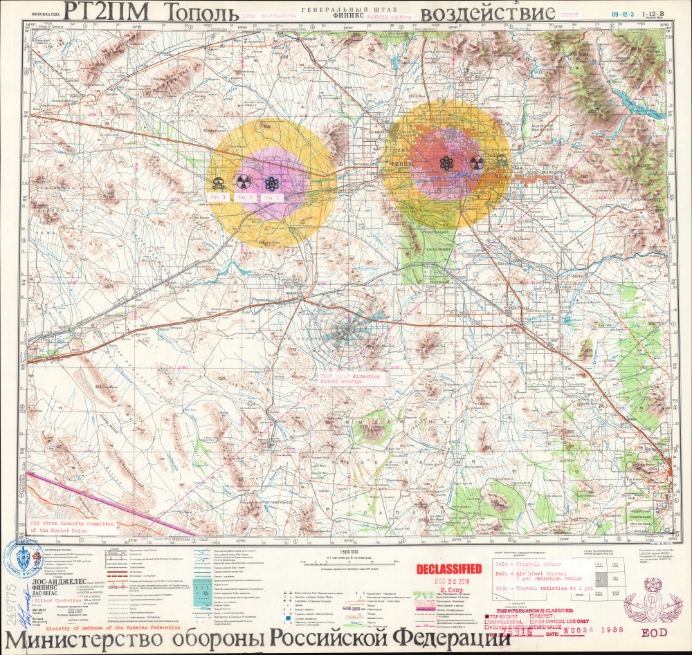
A chilling and thought-provoking 1982 Soviet Cold War map of Phoenix, Arizona, illustrating Russian plans for a nuclear ICBM attack. Two impacts targets are illustrated in manuscript: downtown Phoenix and the Palo Verde Generating Station, one of the largest nuclear power plants in the United States. The map bears the signature of Viktor Chebrikov (Виктор Михайлович Че́бриков; 1923 - 1999), then head of the KGB, as well as stamps showing that it was obtained and translated by American intelligence.
A Closer Look
Three colored rings emanate from the two projected impact sites and are marked by symbols: an atom, a radiation symbol, and a gas mask. Each ring is assigned a number (1, 2, and 3) corresponding with projected zones of destruction: No. 1 (the atom) depicts the fireball radius, No. 2 projects the air blast thermal 5 psi radiation radius, and No. 3 illustrates the radius of thermal radiation at 1 psi. Stenciled letters identify the type of missile - RT-2PM-Topol mobile intercontinental ballistic missiles.A Unique Document
This map was created by the Ministry of Defense of the Russian Federation using a Soviet military topographic map of Phoenix, Arizona as the base map. On the bottom left, it is signed in pen by Viktor Chebrikov (the head of the KGB from December 1982 until October 1988) just below a stamp of the seal of the State Security Committee of the Soviet Union (better known as the KGB) - indicating approval.
The map was subsequently acquired (somehow) by U.S. Intelligence, after which English-language stamps and paste-downs were added, denoting classification data and offering translations. These include, 'This Information Is Classified: Top Secret. By 2591G. Date Aug. 24 1988'. We have been unable to trace 2591G, thus we do not know if it refers to an American intelligence organization (such as the CIA, NSA, etc.) or the military. Red typewritten pastedowns translate critical content including the stenciled name of the Ministry of Defense, the RT-2PM-Topol Impact zones, the KBG seal, and Chebrikov's signature. A stamp of the U.S. Army's Master or Officer Explosive Ordnance Disposal badge appears in the lower right. A final red stamp at center declares that the map was 'DECLASSIFIED' on December 22, 2016, by 'G. Lang'.The Cold War
The Cold War was a geopolitical conflict between the United States and the Soviet Union, and their respective allies, the Western Bloc and the Eastern Bloc, which began following World War II (1939 - 1945). The Cold War is generally considered to have begun with the 1947 Truman Doctrine and ended with the 1991 dissolution of the Soviet Union. During the course of the conflict, both the United States and the Soviet Union developed powerful nuclear arsenals. While there was always a threat of nuclear war, the apocalyptic cost of such an exchange kept both sides from engaging in direct warfare. Instead, with no large-scale engagement, the Cold War was fought through various proxy wars, espionage, propaganda campaigns, embargos, and psychological warfare. Each superpower supported major regional conflicts centered around an ideological and geopolitical struggle for global influence.Publication History and Census
The base map was printed in Kiev, Ukraine in November 1982, as indicated by the code at bottom right XI-82-К. We have been unable to find any other Soviet ICBM or nuclear attack maps. Similarly, we have been unable to locate any other documents bearing this combination of signatures, seals, and stamps, making this a unique and disturbing artifact recalling the Cold War specter of nuclear annihilation.
Condition
Very good.
References
Davies, J. and A. Kent, The Red Atlas: How the Soviet Union Secretly Mapped the World (Chicago: University of Chicago Press) 2017.