This copy is copyright protected.
Copyright © 2025 Geographicus Rare Antique Maps
Digital Image: 1768 Bellin / Horrebow / Knoff map of Iceland
Iceland-horrebow-1768_d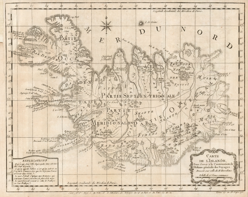

FOR THE ORIGINAL ANTIQUE MAP, WITH HISTORICAL ANALYSIS, CLICK HERE.
Digital Map Information
Geographicus maintains an archive of high-resolution rare map scans. We scan our maps at 300 DPI or higher, with newer images being 600 DPI, (either TIFF or JPEG, depending on when the scan was done) which is most cases in suitable for enlargement and printing.
Delivery
Once you purchase our digital scan service, you will receive a download link via email - usually within seconds. Digital orders are delivered as ZIP files, an industry standard file compression protocol that any computer should be able to unpack. Some of our files are very large, and can take some time to download. Most files are saved into your computer's 'Downloads' folder. All delivery is electronic. No physical product is shipped.
Credit and Scope of Use
You can use your digial image any way you want! Our digital images are unrestricted by copyright and can be used, modified, and published freely. The textual description that accompanies the original antique map is not included in the sale of digital images and remains protected by copyright. That said, we put significant care and effort into scanning and editing these maps, and we’d appreciate a credit when possible. Should you wish to credit us, please use the following credit line:
Courtesy of Geographicus Rare Antique Maps (http://www.geographicus.com).
How Large Can I Print?
In general, at 300 DPI, you should at least be able to double the size of the actual image, more so with our 600 DPI images. So, if the original was 10 x 12 inches, you can print at 20 x 24 inches, without quality loss. If your display requirements can accommodate some loss in image quality, you can make it even larger. That being said, no quality of scan will allow you to blow up at 10 x 12 inch map to wall size without significant quality loss. For more information, it is best consult a printer or reprographics specialist.
Refunds
If the high resolution image you ordered is unavailable, we will fully refund your purchase. Otherwise, digital images scans are a service, not a tangible product, and cannot be returned or refunded once the download link is used.
Niels Horrebow (Septemner 17 1712 - May 20, 1760) was a Danish lawyer now known best for writing The Natural History of Iceland (Tilforladelige efterretninger om Island) in 1752. It was intended to correct errors in past natural histories of Iceland, whose authors had written about the island without ever visiting it. Horrebow lived there for two years, studying not only Iceland's animals, plants, weather, and geological features but also the cultural practices of the Icelandic people themselves. Horrebow was able to secure access to the previously suppressed 1734 Knoff map of Iceland, and his inclusion of a version of it in his work brought it to a wide audience. More by this mapmaker...
Jacques-Nicolas Bellin (1703 - March 21, 1772) was one of the most important cartographers of the 18th century. With a career spanning some 50 years, Bellin is best understood as geographe de cabinet and transitional mapmaker spanning the gap between 18th and early-19th century cartographic styles. His long career as Hydrographer and Ingénieur Hydrographe at the French Dépôt des cartes et plans de la Marine resulted in hundreds of high quality nautical charts of practically everywhere in the world. A true child of the Enlightenment Era, Bellin's work focuses on function and accuracy tending in the process to be less decorative than the earlier 17th and 18th century cartographic work. Unlike many of his contemporaries, Bellin was always careful to cite his references and his scholarly corpus consists of over 1400 articles on geography prepared for Diderot's Encyclopedie. Bellin, despite his extraordinary success, may not have enjoyed his work, which is described as "long, unpleasant, and hard." In addition to numerous maps and charts published during his lifetime, many of Bellin's maps were updated (or not) and published posthumously. He was succeeded as Ingénieur Hydrographe by his student, also a prolific and influential cartographer, Rigobert Bonne. Learn More...
Magnús Arason (1683 - 1728) was an Icelandic mathematician and cartographer. Having begun his studies in Iceland, he traveled to Copenhagen in 1705 to study engineering. He served as a military engineer under Peder Tordenskjold in the Great Northern War. In 1721, King Fredrik IV of Denmark sent him back to Iceland to survey and map both the land and the sea along the coast of his native country. He was the first to carry out accurate land measurements in Iceland. While engaged in surveying the coast, he died by drowning. Learn More...
Thomas Hans Henrik Knoff (January 31, 1699 - January 25, 1765) was a Norwegian army surveyor. Little is known of his education or service, prior to 1730 when he was sent to Iceland by the Danish government to continue and complete Magnús Arason's task of surveying the country. Knoff completed the work in 1734, but made the error of sending a copy of the map to a superior in Norway - an act that outraged his Danish employers. The Danish king stopped short of accusing Knoff with treason - which some had accused him of - but settled for suppressing the maps. These were declared state secrets by the Danish govenment until 1752, when they were provided to Danish scholar Niels Horrebow; through his work the map would be widely disseminated. Knoff's career did not end with the political kerfuffle: we see him engaged in surveys of the border of Norway and Sweden in 1742, Learn More...
Copyright © 2025 Geographicus Rare Antique Maps | Geographicus Rare Antique Maps
This copy is copyright protected.
Copyright © 2025 Geographicus Rare Antique Maps