Digital Image: 1899 George Gill Chromolithograph Wall Map of India, Nepal, and Burma
India-gill-1899_d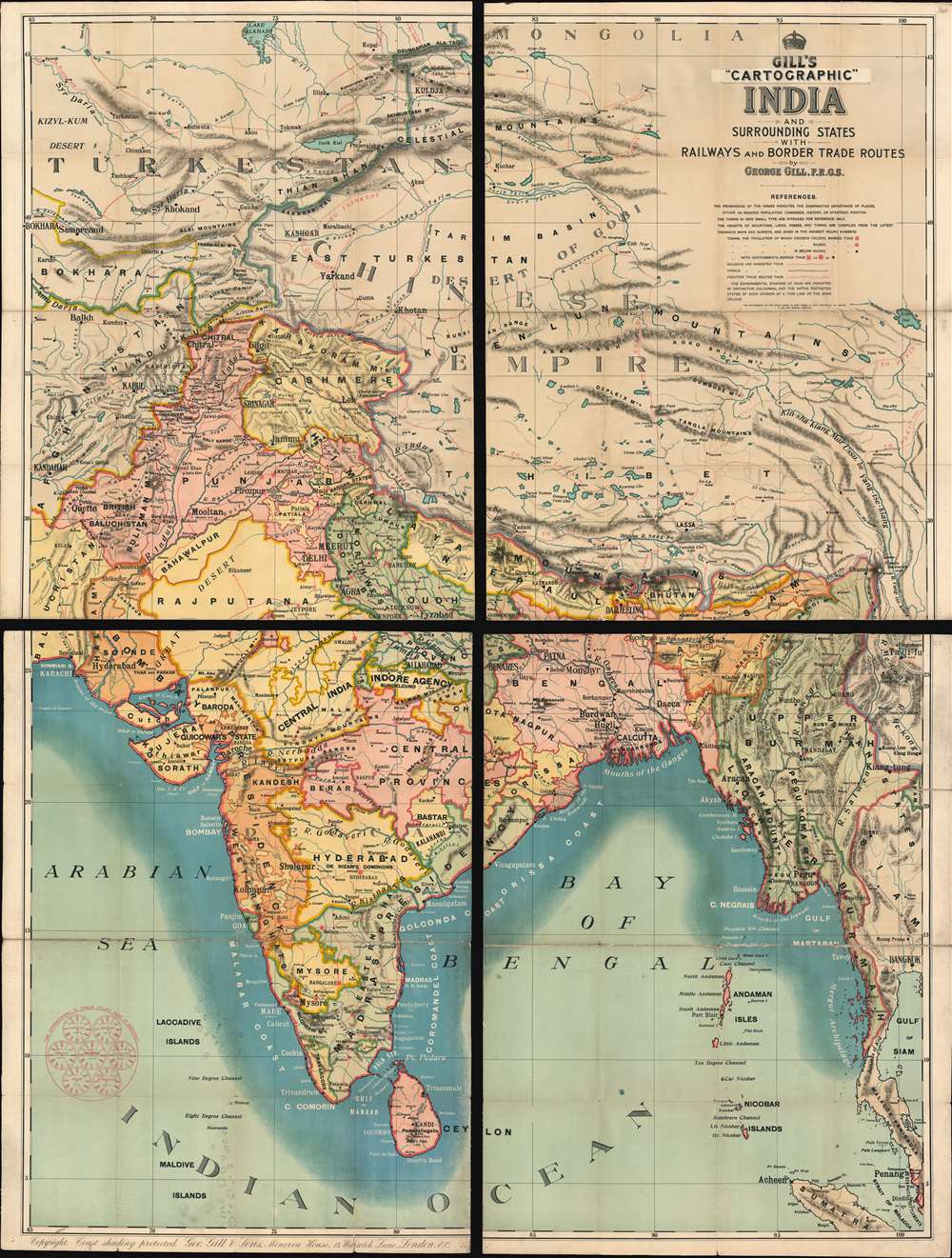

Title
Gill's Cartographic India and Surrounding States with Railways and Border Trade Routes
1899 (undated) 81 x 61 in (205.74 x 154.94 cm)
1899 (undated) 81 x 61 in (205.74 x 154.94 cm)
Description
FOR THE ORIGINAL ANTIQUE MAP, WITH HISTORICAL ANALYSIS, CLICK HERE.
Digital Map Information
Geographicus maintains an archive of high-resolution rare map scans. We scan our maps at 300 DPI or higher, with newer images being 600 DPI, (either TIFF or JPEG, depending on when the scan was done) which is most cases in suitable for enlargement and printing.
Delivery
Once you purchase our digital scan service, you will receive a download link via email - usually within seconds. Digital orders are delivered as ZIP files, an industry standard file compression protocol that any computer should be able to unpack. Some of our files are very large, and can take some time to download. Most files are saved into your computer's 'Downloads' folder. All delivery is electronic. No physical product is shipped.
Credit and Scope of Use
You can use your digial image any way you want! Our digital images are unrestricted by copyright and can be used, modified, and published freely. The textual description that accompanies the original antique map is not included in the sale of digital images and remains protected by copyright. That said, we put significant care and effort into scanning and editing these maps, and we’d appreciate a credit when possible. Should you wish to credit us, please use the following credit line:
Courtesy of Geographicus Rare Antique Maps (http://www.geographicus.com).
How Large Can I Print?
In general, at 300 DPI, you should at least be able to double the size of the actual image, more so with our 600 DPI images. So, if the original was 10 x 12 inches, you can print at 20 x 24 inches, without quality loss. If your display requirements can accommodate some loss in image quality, you can make it even larger. That being said, no quality of scan will allow you to blow up at 10 x 12 inch map to wall size without significant quality loss. For more information, it is best consult a printer or reprographics specialist.
Refunds
If the high resolution image you ordered is unavailable, we will fully refund your purchase. Otherwise, digital images scans are a service, not a tangible product, and cannot be returned or refunded once the download link is used.
Cartographer
George Gill (April 1, 1836 - November 24, 1901) was a Liverpool and London based schoolmaster and educational publisher active in the late 19th and early 20th centuries. Gill began his career as an educated and schoolmaster who, recognizing a dearth of good educational materials, began publishing in Liverpool in 1864. He transferred the company to London in 1879, becoming a limited company under the imprint of George Gill and Sons. In time the firm was taken over by his sons, George Reginald Gill (1862 - and Claude Edward Gill (August 30, 1872 - August 16, 1960). The firm published books and maps for schoolrooms. Advertisements for their 'Cartographic' appear in educational periodicals from 1885 to about 1901. Under the Gill family the educational publishing firm prospered until closing its doors in 1941. The firm was based at Minerva House, no. 12 Warwick lane, London. More by this mapmaker...