This item has been sold, but you can get on the Waitlist to be notified if another example becomes available, or purchase a digital scan.
1563 Gastaldi / Ramusio Map of South Asia: India, Arabia, Persian Gulf
India-ramusio-1563$1,750.00

Title
Seconda Tavola.
1563 (undated) 11 x 15.25 in (27.94 x 38.735 cm)
1563 (undated) 11 x 15.25 in (27.94 x 38.735 cm)
Description
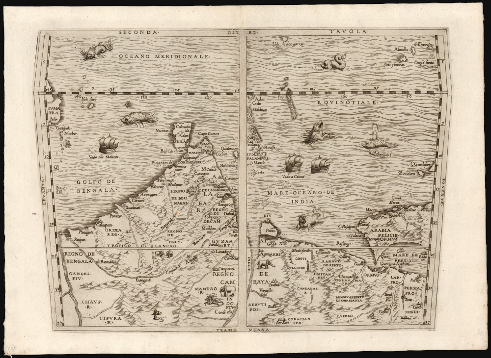
This is a scarce copperplate edition, commonly dated 1563, of the first accurate map of South Asia, including India, Arabia, and the Persian Gulf. It was drawn for Giovanni Battista Ramusio by his friend, the great cartographer Giacomo Gastaldi. The map was first published in Volume I of Ramusio's delle Navigationi et Viaggi in 1554, but this copperplate edition was engraved by Niccolo Nelli to replace the original woodblock after it was lost in a fire.
It is possible that examples of the woodcut maps survived the fire. It is also possible that the 1557 date for the fire is incorrect. It is also possible that the volume containing these maps was bound and published prior to the fire. None of this aids in the positive dating of the copperplate maps, and we cannot discount the possibility that the 1563 date is spurious and that the copperplates may first appear in the 1588 editions or even 1606 or 1613. Pending further study, we must adhere to the conventional dating of 1563 for the present work. Six examples of the map are listed in OCLC, four with the date 1613 assigned.
A Closer Look
This southern-oriented map spans Arabia, the Persian Gulf, and India; the west coast of Sumatra appears at the eastern extreme of the map. Ultimately derived from Portuguese sources, the map is centered roughly on Goa, the administrative center of the Portuguese empire in the east. It is among the earliest printed maps to mark Bahrain in the Persian Gulf, as well as Hormuz, Diu, Goa, and Cochin. The islands of the Indian Ocean are better presented than before: the Maldives are illustrated reasonably accurately. Sri Lanka is accurately placed, with Adam's Peak identified; the city of Columbo is also shown (its old name of Kolomtota is here transliterated 'Colmucho'). In addition to Sumatra, the Nicobar Islands appear in the eastern part of the Indian Ocean. The plate is richly decorated, with an abundance of elephants and lions, six sea monsters, and three Portuguese-style ships. (Two of these are marked as 'bound for Calicut' and one 'bound for the Moluccas.') In the map's border, the cardinal directions are labeled according to the Italian convention of naming the winds.Publication History and Census
This is the second of three maps of Africa and Asia prepared by Gastaldi for Ramusio's work. The three maps first appeared in Ramusio's 1554 Voyages as woodcuts engraved by Matteo Pagano. Robert Karrow, Richard Betz, Thomas Suarez, and with them, the overwhelming consensus of catalogers in both academia and the trade agree that these woodblocks were destroyed in a warehouse fire in 1557 and replaced in new copperplate versions first appearing in the 1563 second edition of Ramusio's work. The presence of the 1554 woodcut maps in no fewer than three examples of the 1563 edition made available digitally by their institutions complicates this timeline. Also, we have found no examples of the copperplate maps in any 1563 edition of the book made thus available.It is possible that examples of the woodcut maps survived the fire. It is also possible that the 1557 date for the fire is incorrect. It is also possible that the volume containing these maps was bound and published prior to the fire. None of this aids in the positive dating of the copperplate maps, and we cannot discount the possibility that the 1563 date is spurious and that the copperplates may first appear in the 1588 editions or even 1606 or 1613. Pending further study, we must adhere to the conventional dating of 1563 for the present work. Six examples of the map are listed in OCLC, four with the date 1613 assigned.
CartographerS
Giacomo Gastaldi (c. 1500 - October, 1566) was an Italian astronomer, cartographer, and engineer active in the second half of the 16th century. Gastaldi (sometimes referred to as Jacopo or Iacobo) began his career as an engineer, serving the Venetian Republic in that capacity until the fourth decade of the sixteenth century. During this time he traveled extensively, building a large library relating to voyages and exploration. From about 1544 he turned his attention to mapmaking, working extensively with Gextantiovanni Battista Ramusio, Nicolo Bascarini, and Giovanbattista Pedrezano, as well as taking private commissions for, among others, Venice's Council of Ten. He is credited with the fresco maps of Asia and Africa still extant in the map room of the Doge's Palace. Gastaldi was also one of the first cartographers to embrace copper plate over woodblock engraving, marking an important development in the history of cartography. His 1548 edition of Ptolemy's Geographia was the first to be printed in a vernacular; it was the first to be printed in copperplate. As with his Swiss/German contemporary Münster, Gastaldi's work contained many maps depicting newly discovered regions for the first time, including the first map to focus on the East Coast of North America, and the first modern map of the Indian Peninsula. His works provided the source for the vast majority of the Venetian and Roman map publishers of the 1560s and 70s, and would continue to provide an outsize influence on the early maps of Ortelius, De Jode, and Mercator. More by this mapmaker...
Giovanni Battista Ramusio (July 20, 1485 - July 10, 1557) was an Italian civil servant, humanist, scholar, historian, and geographer active in the middle part of the 16th century. Ramusio spent most of his life in the service of the Republic of Venice, first as part of that state's embassy to France, and later as a reporter on voyages and discoveries. He was born to an illustrious family in Treviso and moved to Vencie as a young man, where his father was a magistrate. He studied at the University of Padua but may not have received a full degree. He entered the civil service shortly after leaving the university and was immediately assigned to diplomatic service for his facility with languages, particularly French. His most significant contribution to cartography is his publication of Navigationi et Viaggi a collection of travel narratives he collected in his service to the state. The narratives include those of Marco Polo, Niccolò Da Conti, Magellan, Alvar Nuñez Cabeza de Vaca, Giosafat Barbaro, and Tomé Pires, among others. Some of the voyages appearing in the Navigationi et Viaggi are otherwise unknown, marking it as an exceptionally important volume. Ramusio died in Venice in 1557. Learn More...
Source
Ramusio, G. B., Terzo Volume Delle Navigatione et Viaggi ..., (Venice: Giunti) 1563.
Condition
Good. Extensive worming at centerfold invisibly repaired with small areas facsimile reinstatement of image.
References
OCLC 52982324. Gole, S., Early Maps of India, 4. Karrow, R., Mapmakers of the Sixteenth Century and Their Maps 30/74.1. Not in Bifolca.