Title
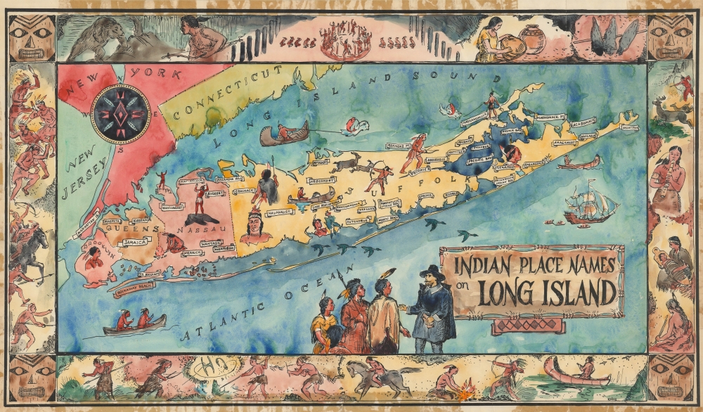
Indian Place Names on Long Island.
1957 (undated)
15.25 x 26.25 in (38.735 x 66.675 cm)
Description
This is the original 'Kash' watercolor artwork for a c. 1957 pictorial map of Long Island celebrating the island's American Indian heritage.
A Closer Look
Coverage embraces Long Island and some adjacent parts of New York, Connecticut, and New Jersey. Long Island is divided into Brooklyn, Queens, Nassau, and Suffolk counties. American Indian place names are identified throughout - including 'Manhattan'. The island and surrounding waters feature American Indians engaged in various hunting, fishing, and ceremonial activities. The title cartouche, in the bottom right, is on a hide stretched to dry. Nearby, a pilgrim converses with a group of Native Americans. Surrounding the map is a decorative border composed of figural representations of various American Indian activities, ranging from hunting and horse riding, to dancing and the arts. The artist 'Kash', who signed the map in the lower right, has proven impossible to identify.American Indian Heritage on Long Island
Before European colonization, Long Island was home to various Native American tribes, including the Lenape (also known as the Delaware), Montaukett, Shinnecock, and others. These indigenous communities were based on agriculture, fishing, and hunting. The island's fertile soil yielded crops like maize, beans, and squash, while its proximity to the Atlantic provided abundant seafood. With the arrival of European settlers in the 17th century, these native populations faced diseases, land encroachment, and conflicts that led to significant disruptions and population declines. Nonetheless, descendants of these tribes continue to preserve their cultural heritage on Long Island, with the Shinnecock Indian Nation, for example, federally recognized and maintaining a reservation in Southampton. As this map suggests, Long Island's American Indian heritage is also preserved in the island's nomenclature.Publication History and Census
This map was drawn by 'Kash'. This is his original manuscript art. The piece was subsequently printed for commercial distribution c. 1957 by Orion Press of New York. As original art, this is a unique piece.
Condition
Good. Original watercolor artwork. Someone, likely the artist, glued the piece to a board with highly caustic gum tape. We were able to remove the tape from the map and the map from the board, but there remains permanent residue damage on map, mostly confined to margins. Laid down on archival tissue for stabilization.
References
Library of Congress, Ethel M. Fair Map Collection, #783.