1935 War Office International Map of the World Sheet North I-37 - Damascus
IntMapDamascusNI37-waroffice-1935$200.00

Title
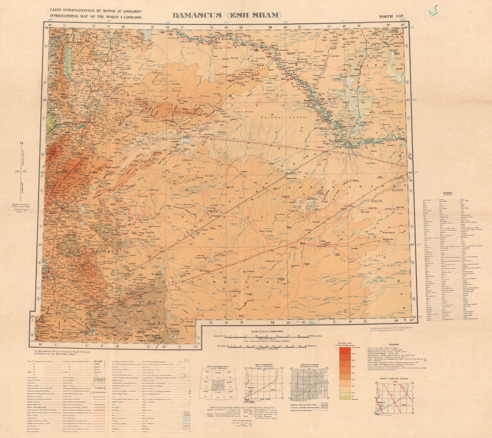
Carte Internationale du Monde au 1,000,000 International Map of the World 1 : 1,000,000 Damascus (Esh Sham) North I-37.
1935 (dated) 26 x 29 in (66.04 x 73.66 cm) 1 : 1000000
1935 (dated) 26 x 29 in (66.04 x 73.66 cm) 1 : 1000000
Description
This is a 1935 British War Office edition of the Damascus sheet of the International Map of the World. The International Map of the World was a multi-national effort initiated in the early 20th century to create a uniform large-scale map of the world. Although the effort ultimately floundered and was left incomplete, many individual sheets were prepared, this being the Damascus sheet.
A Closer Look
The map depicts southern Syria and parts of Lebanon, Jordan, and Iraq. Damascus is situated near the left border, and Amman, Jordan, is in the lower left. Color indicates altitude. Cities and towns are labeled throughout.The International Map of the World
First proposed in 1891 by German geographer Albrecht Penck, the International Map of the World was a project to create a world map at a uniform scale and to internationally agreed standards. The project was discussed at geographical conferences for the next 15 years until, at the 1909 First International Conference in London, representatives of 10 nations agreed on standards and guidelines. Over the next four years, a grid reference system was finalized. The Ordnance Survey in London hosted the Central Bureau for the Map of the World, and by 1939, 350 of the 1,000 planned maps had been completed. The United Nations took over management of the project after World War II, and progress continued into the 1950s. However, the project began to lose supporters by the mid-1960s, being criticized by some and being of 'no practical use.' UNESCO declared the project unfeasible in 1989 and stopped monitoring progress. Today, scholars have taken a more complex view of the entire project and have proposed that it be evaluated for its importance to international relations and other aspects of global life instead of simply a question of cartography.Publication History and Census
This map was created by the Geographical Section, General Staff of the War Office, and published in 1935. We note a single cataloged example of the present 1935 edition in OCLC, which is part of the collection at the Bayerische Staatsbibliothek. Examples of sheet I-37 dating from between 1918 and 1935 appear in OCLC.Cartographer
The British War Office (1857 - 1964) was a department of the British Government responsible for the administration of the Royal Army until 1964, when its functions were transferred to the Ministry of Defense. The War Office was to the Royal Army what the Admiralty was to the Royal Navy, and later, the Air Ministry. Within the War Office, the General Staff Topographical Section was responsible for thousands of maps issued for British intelligence and military use. The Topographical Section was renamed Geographical Section in April 1907. Many, once their military use passed, were offered through licensed agents to the general public. The sole London agent for War Office material was Edward Stanford. More by this mapmaker...
Condition
Very good. Light wear along original fold lines.
References
OCLC 163323910.