This item has been sold, but you can get on the Waitlist to be notified if another example becomes available, or purchase a digital scan.
1868 Rogers Map of Manhattan, New York City (North of 86th Street)
IslandManhattan-rogers-1868$550.00

Title
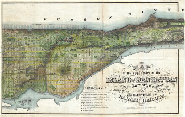
Map of the Upper Part of the Island of Manhattan above eighty-sixth street arranged to illustrate the Battle of Harlem Heights.
1868 (dated) 15 x 24 in (38.1 x 60.96 cm) 1 : 15000
1868 (dated) 15 x 24 in (38.1 x 60.96 cm) 1 : 15000
Description
A stunning and rare 1868 Map of the northern part of the island of Manhattan, New York city by W. C. Rogers. The map covers the upper part of Manhattan, above 86th street (including Morningside Heights, Manhattan Valley, Harlem, Inwood, the Upper West Side, the Upper East Side, etc...) in extraordinary detail, depicting streets, buildings, estates and in many cases individual trees. This map is most certainly based upon the 1836 Topographical Map of the City and County of New York drawn by David H. Burr and published by J.H. Colton. Colton's map was perhaps the ‘finest example of artistic mapmaking applied to the Island of Manhattan' (I.N. Phelps Stokes). This map uses only the northern portion of Colton's map, but features the same stunning detail. Beautifully hand colored to illustrate the Battle of Harlem Heights. This is the finest map to specifically detail northern Manhattan that we are aware of.
Shannon commissioned this map to illustrate the events leading to the British takeover of New York City and vicinity during the American Revolutionary War. Specifically, it details the Battle of Harlem Heights and the Battle of Long Island. In 1776 the British General William Howe, fleeing Boston, regrouped and landed his forces on Long Island and Staten Island. After defeating George Washington at the Battle of Long Island, Howe sized control of New York City and most of Manhattan. A series of subsequent skirmishes culminated in the Battle of Harlem Heights, in what is now Morningside Heights, New York City. Washington controlled the highlands and galvanized his troops to a strong defense, holding the heights against superior British numbers and firepower. Nonetheless, the position proved untenable and Washington and his forces retreated northward to Westchester County. Howe, keen to size the advantage, landed troops in Westchester, a flanking maneuver intending to encircle Washington's forces. Washington, alerted to the tactic entrenched himself in White Plains, but was unable to hold against Howe's. Howe proceeded to drive Washington across New Jersey into Pennsylvania where he famously crossed the Delaware on December 26th to surprise a Brigade of Hessian mercenaries in the Battle of Trenton – a strategic Continental victory and major turning point in the war.
Prepared for inclusion in the 1868 edition of Joseph Shannon's Manual Of The Corporation Of The City of New York. An important piece for collectors of New York City cartography.
CartographerS
Joseph Shannon (fl. c. 1850 - 1869) produced a series of New York City almanacs and fact books entitled Manual of the Corporation of the City of New York. Shannon's Manual is very similar to the more common manual issued by David T. (Thomas) Valentine (1801 - 1869). The production of this annual manual was the responsibility of the Clerk of the Common Council of the City of New York, a position held at different times by both Shannon and Valentine. The manual included facts about the City of New York, City Council information, history, and reported on the progress of public works such as Central Park. More by this mapmaker...
William C. Rogers (fl. c. 1860 - 1873) was a New York based lithographer active in the mid to late 19th century. His is best known for his engravings issued in conjunction with Joseph Shannon's Manual of the Corporation fo the City of New York. Rogers issued several maps of New York City in the 1860s and 1870s. Learn More...
Source
Shannon, J., Shannon's Manual of the Corporation of the City of New York, (1868 edition).
Condition
Very good. Some damage and toning along original fold lines. Some creasing and cracking, especially near top left quadrant. Professionally flattened and backed with archival tissue.
References
Phillips (America) 537. Haskell, D., Manhattan Maps A Co-operative List, 1196.