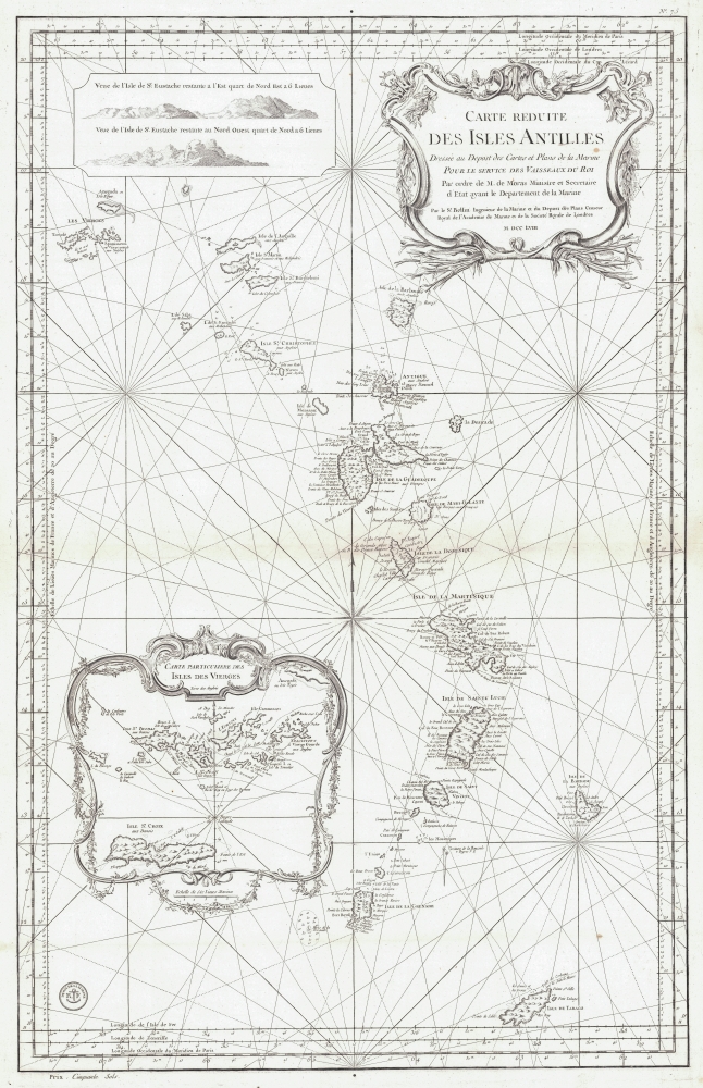
1758 Bellin Map of the Lesser Antilles
IslesAntilles-bellin-1758$1,100.00


Title
Carte Reduite des Isles Antilles.
1758 (dated) 36 x 22.5 in (91.44 x 57.15 cm) 1 : 1250000
1758 (dated) 36 x 22.5 in (91.44 x 57.15 cm) 1 : 1250000
Description
This is a 1758 Jacques-Nicolas Bellin nautical chart or map of the Lesser Antilles. Published two years into the Seven Years' War (1756 - 1763), this map highlights the rich sugar-producing French, British, and Dutch colonies in the Antilles - all up for grabs in the conflict.
A Closer Look
The map depicts the Lesser Antilles from the Virgin Islands south to Tobago. Coves, points, bays, harbors, and safe anchorages are identified on every major island. An inset in the upper left contains two coastal views of Sint Eustatius (labeled here as St. Eustache). In the bottom left, an inset focuses on the Virgin Islands and identifies key islands, including St. Croix and St. Thomas. The navigation channels through the islands are illustrated as well.Seven Years' War in the Caribbean
The Seven Years' War (1756 - 1763) was a global conflict (some even call it the first World War) that involved most European powers and their far-flung colonial empires. Beginning in 1756, fighting was initially confined to Europe until 1759, when the British attacked Martinique and Guadeloupe, successfully capturing the latter. After Guadeloupe surrendered, Marie-Galante, La Désirade, Petite Terre, and Les Saintes (all nearby islands) also surrendered to the British. The British then captured Dominica in 1761 and Martinique, Grenada, and Saint Lucia in 1762. The British even successfully captured Havana, the pearl of the Spanish Greater Antilles, 1762. Although broadly successful, these naval campaigns took an egregious toll. While combat causalities were minimal, over 5,000 British soldiers died of disease in Cuba alone. Despite the human cost, the British achieved their goal: territory in the Caribbean that could be used as bargaining chips at the negotiating table.Publication History and Census
This map was drawn by Jacques-Nicolas Bellin and published by the French Dépôt des Cartes et Plans de la Marine in 1758. We note 7 cataloged examples in OCLC which are part of the collections at Harvard University, the University of Wisconsin - Milwaukee, the Universitätsbibliothek Bern, the University of Michigan, the Bibliothèque cantonale et universitaire - Lausanne, the Biblioteca Nacional de España, and the Bibliothèque nationale de France.CartographerS
Jacques-Nicolas Bellin (1703 - March 21, 1772) was one of the most important cartographers of the 18th century. With a career spanning some 50 years, Bellin is best understood as geographe de cabinet and transitional mapmaker spanning the gap between 18th and early-19th century cartographic styles. His long career as Hydrographer and Ingénieur Hydrographe at the French Dépôt des cartes et plans de la Marine resulted in hundreds of high quality nautical charts of practically everywhere in the world. A true child of the Enlightenment Era, Bellin's work focuses on function and accuracy tending in the process to be less decorative than the earlier 17th and 18th century cartographic work. Unlike many of his contemporaries, Bellin was always careful to cite his references and his scholarly corpus consists of over 1400 articles on geography prepared for Diderot's Encyclopedie. Bellin, despite his extraordinary success, may not have enjoyed his work, which is described as "long, unpleasant, and hard." In addition to numerous maps and charts published during his lifetime, many of Bellin's maps were updated (or not) and published posthumously. He was succeeded as Ingénieur Hydrographe by his student, also a prolific and influential cartographer, Rigobert Bonne. More by this mapmaker...
Dépôt des Cartes et Plans de la Marine (fl. 1720 - present), often called the Dépôt de Marine, was a French hydrographic mapping organization founded in 1720 under Charles-Hercule of Albert de Luynes (1674 - 1734). Much like the U.S. Coast Survey, the British Admiralty, and the Spanish Deposito Hydrografico, the Dépôt was initiated as a storehouse and distribution center of existing nautical and marine charts. Eventually the Dépôt initiated its own mapping activities in an attempt to improve and expand upon existing material. Some of the more prominent cartographers and hydrographers associated with the of Dépôt des Cartes were, Philippe Buache, Jacques-Nicholas Bellin, Giovanni Rizzi-Zannoni, Rigobert Bonne, and Jean Nicolas Buache. Learn More...
Condition
Excellent. Light wear along original fold lines. Very light spot of discoloration in title cartouche.
References
OCLC 715124210, 776715600, 729835335, 945089239.