This copy is copyright protected.
Copyright © 2025 Geographicus Rare Antique Maps
Digital Image: 1873 Gilpin Thermal Map of North America
Isothermal-gilpin-1873_d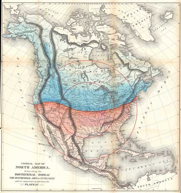

FOR THE ORIGINAL ANTIQUE MAP, WITH HISTORICAL ANALYSIS, CLICK HERE.
Digital Map Information
Geographicus maintains an archive of high-resolution rare map scans. We scan our maps at 300 DPI or higher, with newer images being 600 DPI, (either TIFF or JPEG, depending on when the scan was done) which is most cases in suitable for enlargement and printing.
Delivery
Once you purchase our digital scan service, you will receive a download link via email - usually within seconds. Digital orders are delivered as ZIP files, an industry standard file compression protocol that any computer should be able to unpack. Some of our files are very large, and can take some time to download. Most files are saved into your computer's 'Downloads' folder. All delivery is electronic. No physical product is shipped.
Credit and Scope of Use
You can use your digial image any way you want! Our digital images are unrestricted by copyright and can be used, modified, and published freely. The textual description that accompanies the original antique map is not included in the sale of digital images and remains protected by copyright. That said, we put significant care and effort into scanning and editing these maps, and we’d appreciate a credit when possible. Should you wish to credit us, please use the following credit line:
Courtesy of Geographicus Rare Antique Maps (http://www.geographicus.com).
How Large Can I Print?
In general, at 300 DPI, you should at least be able to double the size of the actual image, more so with our 600 DPI images. So, if the original was 10 x 12 inches, you can print at 20 x 24 inches, without quality loss. If your display requirements can accommodate some loss in image quality, you can make it even larger. That being said, no quality of scan will allow you to blow up at 10 x 12 inch map to wall size without significant quality loss. For more information, it is best consult a printer or reprographics specialist.
Refunds
If the high resolution image you ordered is unavailable, we will fully refund your purchase. Otherwise, digital images scans are a service, not a tangible product, and cannot be returned or refunded once the download link is used.
William Gilpin (October 4, 1813 – January 20, 1894) was an American explorer, politician, and land speculator. His ardent belief in Manifest Destiny was wedded to odd climatological theories, which led to the creation of a series of maps in his book Mission of the North American People. He was born near Philadelphia to a wealthy family, was privately educated, and graduated from the University of Pennsylvania in 1833. He attended West Point for a year but did not graduate. He was commissioned as a Second Lieutenant in the U.S. Army and served in the Seminole Wars and resigned two years later, in 1838. After leaving the army, Gilpin moved to St. Louis where he became a newspaper editor and opened a law practice. In 1843 Gilpin accompanied John C. Frémont along the Santa Fe Trail and eventually to the Oregon Country. He settled in the Willamette Valley, helped organize the provisional government, and aided in drafting a petition to the United States Congress requesting support for the provisional government. He was charged with carrying the petition to Congress, and on his way to Washington he helped foment "Oregon fever" and promoted the territory. In 1846, Gilpin again joined the army to fight in the Mexican-American War. This time he was commissioned as a Major and participated in the campaign to capture New Mexico. After the end of the war, he returned to Missouri and resumed his law practice. In the early 1860s, the border war between Kansas and Missouri prompted Gilpin to join the Republican party. He was later rewarded for this move by President Lincoln, because hew as appointed governor of the newly formed Colorado Territory in May 1861. Gilpin's time as governor, however, was short lived. Under threat of Confederate invasion at the beginning of the Civil War, Gilpin created a military regiment without authorization from the federal government. Since he did not have the money to do so, Gilpin issued $375,000 in drafts on the federal treasury. At first, this move was supported by the people of Colorado, but once it became clear that the treasury was not going to validate the drafts, things quickly turned sour for Gilpin. Petitions began to be circulated calling for his removal. Despite the controversy, the creation of the 1st Colorado Volunteers proved to be fortuitous after the Confederates launched an invasion from the New Mexico Territory in the spring of 1862. The Colorado volunteers played a critical role in routing the Texans at the Battle of Glorieta Pass, which became known as the 'Gettysburg of the West'. Even so, Gilpin was removed in April 1862 by President Lincoln. Gilpin died in Denver in 1894 after being run over by a horse and buggy. More by this mapmaker...
Joshua Ballinger Lippincott (March 18, 1813 - 1886) was the founder of J. B. Lippincott and Co. (1836-2002), an American publishing house founded in Philadelphia, Pennsylvania in 1836. Lippincot was born in Juliustown, New Jersey. He relocated to Philadelphia in 1827 where he worked at Clark's Bookstore (1827 - 1836). Clark's went bankrupt in 1836 and in the same year Lippincott started his own company. Meeting with considerable success, in 1849, he acquired the entire stock of the publishing house Grigg, Elliott, and Company. This acquisition positioned Lippincott as the primer publisher in Philadelphia. The next year, 1850, the firm reorganized and took a a new partner, Grumbo, emerging as Lippincott, Grumbo, and Company. In 1855, the partner Grumbo retired and the company name reverted to J.B. Lippincott and Company. He founded Lippincott’s Magazine in 1868 and the Medical Journal a few years later. In 1875, Lippincott founded an agency in London to import European literature into the United States. During his life he was a director of the Reading Railroad, the Philadelphia Saving Bank, the Union League Club, and the Academy of Fine Arts, as well as a trustee of the University of Pennsylvania. His firm became the J. B. Lippincott Company in 1878, and was subsequently acquired by Harper and Row Publishers in 1978. In 1995, Wolters Klumer N.V. of the Netherlands purchased the company, which became Lippincott-Raven Publishers in 1996 and Lippincott Williams and Wilkins in 1998. In 2002, the firm ceased to exist and became Wolters Kluwer Health. Learn More...
Copyright © 2025 Geographicus Rare Antique Maps | Geographicus Rare Antique Maps
This copy is copyright protected.
Copyright © 2025 Geographicus Rare Antique Maps