This item has been sold, but you can get on the Waitlist to be notified if another example becomes available, or purchase a digital scan.
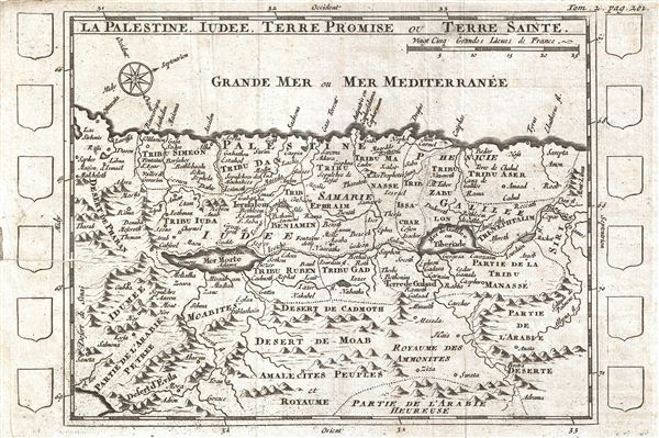
1700 Martineau Map of Israel, Palestine, or the Holy Land
IsraelPalestine-martineau-1700$125.00

Title
La Palestine, Iudee, Terre Promise ou Terre Sainte.
1700 (undated) 6 x 8.75 in (15.24 x 22.225 cm)
1700 (undated) 6 x 8.75 in (15.24 x 22.225 cm)
Description
An uncommon c. 1700 map of Israel, Palestine, or the Holy Land. Centered on the Jordan River Valley, this map covers from the Mediterranean to the Biblical deserts of Moab and the Amalekites. Israel is divided according to the Biblical Tribes of Israel and their neighbors. The map identifies both factual and fictional locations including Jerusalem, Tyre, the Dead Sea, the Sea of Galilee or Lake Tiberius, and on the fictional side the ‘Desert of evil,' and other sites. The map is surrounded by twelve incomplete armorial crests, suggesting that the cartographer may have had plans for this map that did not, in the end, materialize. Prepared for Martineau du Plessis' Nouvelle Geographie, published in 1700.
Cartographer
Martineau Du Plessis (fl. c. 1700) was a French geographer and schoolmaster from Fontenay, possibly Fontenay-le-Comte. He is best known for his multivolume geography, Nouvelle Geographie issued in 1700. Little else is known of his life. More by this mapmaker...
Source
Martineau du Plessis, Nouvelle Geographie, ou Description Exacte de l'Univers (George Gallet, Directeur de l'Imprimerie des Huguetan), vol 2, 1700.
Condition
Very good. Closed verso repair extending approximatly 3 inch from left center margin. Original fold lines. Platemark visible. Blank on verso.
References
Bibliotheque Nationale de France: Réserve A 200 189

