This item has been sold, but you can get on the Waitlist to be notified if another example becomes available, or purchase a digital scan.
1949 Shapiro Zionist Map of Israel Celebrating Its Second Anniversary
IsraelSecondYear2-shapiro-1949$600.00

Title
Second Year of the State of Israel. / שנת שתיים למדינת ישראל
1949 (undated) 25 x 13 in (63.5 x 33.02 cm) 1 : 750000
1949 (undated) 25 x 13 in (63.5 x 33.02 cm) 1 : 750000
Description
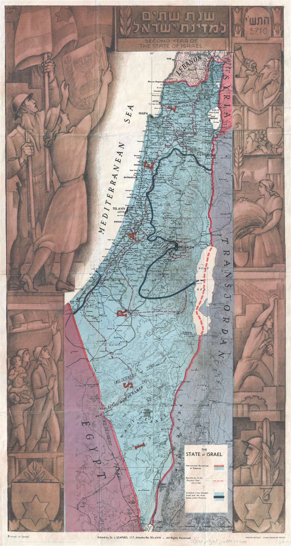
A rare and stunning 1949 Joseph Szapiro (Schapiro) Zionist map of Israel, with striking Social Realist imagery, celebrating the second year after its founding in 1947.The map depicts the region from the Mediterranean Sea to Jordan (Transjordan) and Syria and from Lebanon to Egypt and the Gulf of Eilat (Gulf of Aqaba). Highly detailed, cities, towns, and villages are labeled throughout, with Jerusalem and Tel Aviv given prominence.
Social Realism in Israel
The map's most striking feature is the elaborate decorative art embracing the map proper. The surround is the work of Israeli artist Michael Kara, one of the pioneers in the development of a distinctive Israeli art movement in the late 1940s - 1950s. It contains elements inspired by Communist Social Realism, among them farm and construction workers, as well as Zionist tropes, including immigrant families, Jewish iconography, and a soldier and young women holding aloft the flag. Communist ideology would go on to play a significant role in the development of the Israeli state, influencing, among other things, the rise of the Kibbutz System.The Moving Boundaries of Israel
Three different sets of boundaries are depicted. The international boundaries of Palestine, from before the state of Israel was founded, are illustrated by thick red lines. The boundaries of the 'partition plan' of November 1947 are shown by thin dashed red lines. The third and final set of boundaries are those created by the armistice that ended the 1948 Arab-Israeli War, now known as the Green Line. These territories are the West Bank and Gaza Strip, which are now part of Israel. This map provides a visual summary of the creation and growth of Israel during its first two years of existence.Publication History and Census
This map was created by Michael Kara and Joseph Szapiro and printed by Kfar Monash Printers in Tel Aviv, Israel. It was initially issued as a supplement to the Davar newspaper. There are at least two states of the map, one in English, and another in Hebrew. Our research suggests that the English version, as here, issued in 1949, is the earlier of the two and that the Hebrew variant followed in 1950. This map is rare, with only one example in an institutional collection at the National Library of Israel.Condition
Very good. Even overall toning. Closed tear extending 3.5 inches near center professionally repaired on verso. Blank on verso.
References
National Library of Israel 002367882. OCLC 234164232.