This item has been sold, but you can get on the Waitlist to be notified if another example becomes available, or purchase a digital scan.
1956 Szapiro Map of the Middle East During the Suez Crisis in Hebrew
IsraelSinai-szapiro-1956$375.00

Title
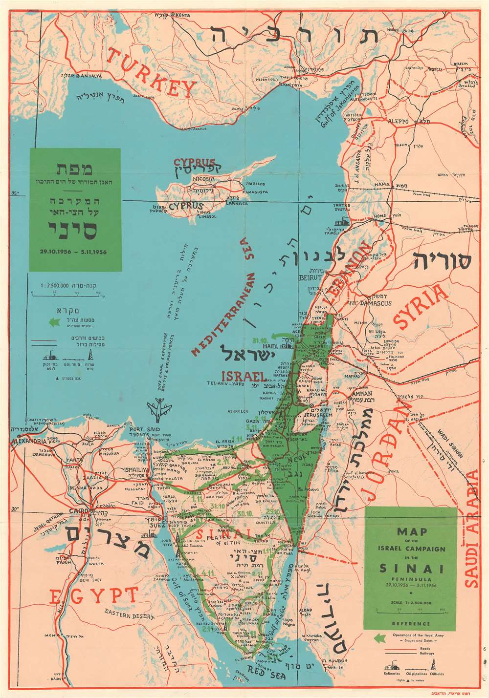
Map of the Israel Campaign in the Sinai Peninsula.
1956 (dated) 19.5 x 13.75 in (49.53 x 34.925 cm) 1 : 2500000
1956 (dated) 19.5 x 13.75 in (49.53 x 34.925 cm) 1 : 2500000
Description
This is a 1956 Shapiro bilingual English and Hebrew map of the Middle East centered on Israel during the 1956 Suez Crisis, which is also known as the Second Arab-Israeli War. Tracing the events of the war, the map depicts the region from Alexandria, Egypt to Syria and Saudi Arabia and from Turkey to the Red Sea. Israel is shaded in green, making it stand out in contrast to the other countries in the region, and the movements of the Israeli armed forces across the Sinai Peninsula are also illustrated in green. These arrows are dated, allowing the viewer to follow the movements of the Israelis throughout the course of the war. A notation in the Mediterranean Sea also marks the presence of the British and French Suez Canal Expedition, complete with an illustration of a fighter jet.
Cities, towns, and villages throughout the region are labeled in both English and Hebrew, with particular attention paid to Israel and the Sinai Peninsula. Roads and railways are also illustrated, as are oil fields, oil pipelines, and refineries.
Cities, towns, and villages throughout the region are labeled in both English and Hebrew, with particular attention paid to Israel and the Sinai Peninsula. Roads and railways are also illustrated, as are oil fields, oil pipelines, and refineries.
The Suez Crisis or the Second Arab-Israeli War
The Suez Crisis is also known by several other names, including the Second Arab-Israeli War, the tripartite aggression in the Arab world, and the Sinai War in Israel. This conflict was an invasion of Egypt by Israel, followed closely by the United Kingdom and France, in an effort to gain Western control of the Suez Canal after Egyptian President Gamal Abdel Nassar nationalized the canal. The conflict lasted from October 29, 1956 – November 7, 1956. Following the Israeli invasion of the Egyptian Sinai Peninsula on October 29, the U.K. and France issued a joint ultimatum to cease fire, which was ignored. This led to Britain and France landing paratroopers along the Suez Canal on November 5, which defeated the Egyptian forces guarding the canal. Through political pressure, the United States, the Soviet Union, and the United Nations forced the withdrawal of all three nations from the Sinai, although the Israelis occupied the peninsula until March 1957. Later it became clear that Israel, France, and the United Kingdom had coordinated their plans before the conflict began. In the end, the episode humiliated Britain and France, with some historians stating that the episode signified the end of Britain's reign as a major world power. It also achieved the opposite of one of their stated goals: instead of removing Nassar from power, the Suez Crisis only strengthened his position.Publication History and Census
This map was created by Shapiro and published the Ariel Printing Press in Tel Aviv in 1956. The OCLC records only two examples in institutional collections at the University of Oklahoma and the National Library of Israel in Jerusalem.Condition
Very good. Even overall toning. Verso repairs to fold separations. Blank on verso.
References
OCLC 908570058.