This item has been sold, but you can get on the Waitlist to be notified if another example becomes available, or purchase a digital scan.
1747 Bowen Map of Italy
Italy-bowen-1747$250.00

Title
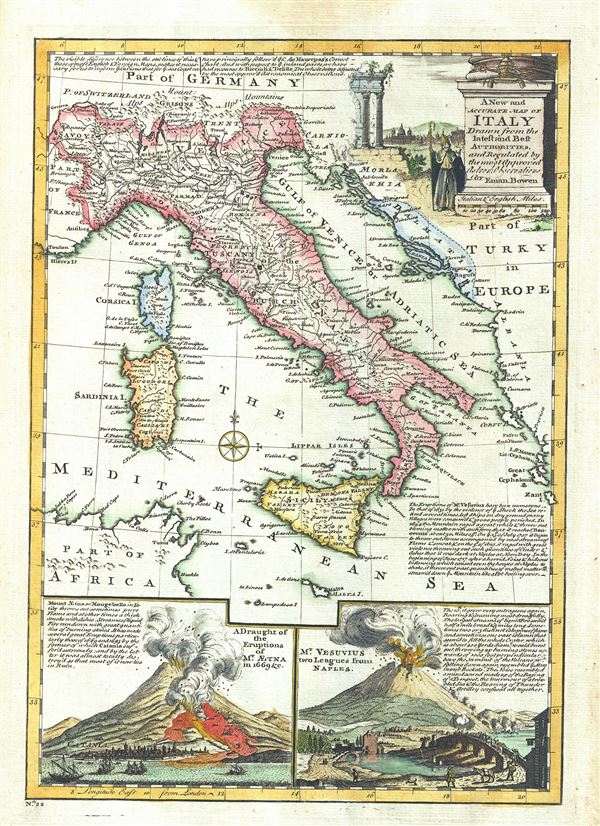
A New and Accurate Map of Italy Drawn from the latest and Best Authorities.
1747 (undated) 13 x 9.5 in (33.02 x 24.13 cm) 1 : 6050000
1747 (undated) 13 x 9.5 in (33.02 x 24.13 cm) 1 : 6050000
Description
This is a charming 1747 map of Italy, issued by the British cartographer Emanuel Bowen. It covers all of Italy from the Alps to Malta, including the Islands of Corsica and Sardinia. Several important towns, cities, roads, rivers, and other topographic features are noted, with mountains rendered in profile. A note along the top border explains the compilation of this map, with the coastlines based on the chart of C. de Maurepas and the interior based on the work of Riccioli and Delisle. Another note in the bottom right quadrant explains the eruptions of Mt. Vesuvius from 1631 to 1717. A beautifully illustrated title cartouche is included in the upper right quadrant.
The bottom of the map features two beautifully illustrated insets, the first being a draught of the eruptions of Mt. Etna in 1669 etc. along with a note on the effects of the eruptions. The second inset illustrates Mt. Vesuvius, two leagues from Naples. A note describing the eruption in detail is included in the second inset. This map was prepares by Emanuel Bowen as plate no. 22 for the 1747 issue of A Complete System of Geography.
The bottom of the map features two beautifully illustrated insets, the first being a draught of the eruptions of Mt. Etna in 1669 etc. along with a note on the effects of the eruptions. The second inset illustrates Mt. Vesuvius, two leagues from Naples. A note describing the eruption in detail is included in the second inset. This map was prepares by Emanuel Bowen as plate no. 22 for the 1747 issue of A Complete System of Geography.
Cartographer
Emanuel Bowen (1694 - May 8, 1767) had the high distinction to be named Royal Mapmaker to both to King George II of England and Louis XV of France. Bowen was born in Talley, Carmarthen, Wales, to a distinguished but not noble family. He apprenticed to Charles Price, Merchant Taylor, from 1709. He was admitted to the Merchant Taylors Livery Company on October 3, 1716, but had been active in London from about 1714. A early as 1726 he was noted as one of the leading London engravers. Bowen is highly regarded for producing some of the largest, most detailed, most accurate and most attractive maps of his era. He is known to have worked with most British cartographic figures of the period including Herman Moll and John Owen. Among his multiple apprentices, the most notable were Thomas Kitchin, Thomas Jeffreys, and John Lodge. Another apprentice, John Oakman (1748 - 1793) who had an affair with and eventually married, Bowen's daughter. Other Bowen apprentices include Thomas Buss, John Pryer, Samuel Lyne, his son Thomas Bowen, and William Fowler. Despite achieving peer respect, renown, and royal patronage, Bowen, like many cartographers, died in poverty. Upon Emanuel Bowen's death, his cartographic work was taken over by his son, Thomas Bowen (1733 - 1790) who also died in poverty. More by this mapmaker...
Source
Bowen, E., A complete system of geography. Being a description of all the countries, islands, cities, chief towns, harbours, lakes, and rivers, mountains, mines, etc., of the known world …, (London) 1747.
Condition
Very good. Original platemark visible. Minor damp stain in top margin, not extending onto printed area. Blank on verso.
References
Rumsey 3733.021. Philips (atlases) 614 (1752 edition).