1948 Jolly Lindgren 'Hysterical' Map of Jackson Hole and Grand Teton, Wyoming
JacksonHole-lindgren-1948$750.00

Title
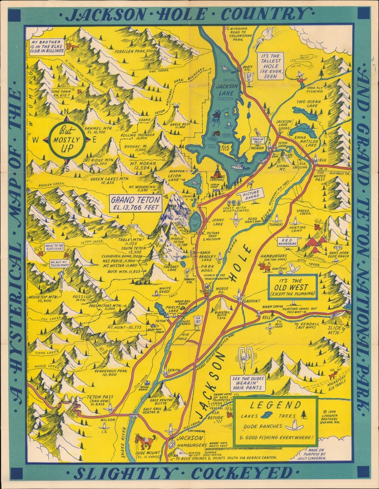
A Hysterical Map of the Jackson Hole Country and Grand Teton National Park. Slightly Cockeyed.
1948 (dated) 22 x 17 in (55.88 x 43.18 cm)
1948 (dated) 22 x 17 in (55.88 x 43.18 cm)
Description
A blend of the comic and the practical, this is a 1948 Jolly Lindgren larger format pictorial map of Jackson Hole and Grand Teton, Wyoming. This is one of the rarer of Lindgren's 'Hysterical' map series, which gained popularity against the grim backdrop of first the Great Depression and World War II.
A Closer Look
The map is loosely centered on the Cathedral Group, with Jackson Lake just north of center. 'Hysterical' vignettes and captions throughout provide humorous commentary on Grand Teton, Jackson Hole, and the vicinity. On the more serious side, Lindgren marks hotels, campsites, ranger stations, shops, mountains, trails, and other key locations. There are several references to hamburgers, including 'Hamburgers (on the hoof) and 'Jackson Hamburgers'.Grand Teton National Park
Grand Teton National Park was established in 1929 in northwestern Wyoming. It is renowned for its stunning mountain landscapes and diverse wildlife. The park dates back to efforts by conservationists like John D. Rockefeller Jr., who played a crucial role in expanding the park. Initially, only the Teton Range and some surrounding lakes were protected, but in the 1940s, Rockefeller quietly purchased over 35,000 acres of land in the Jackson Hole Valley and donated it to the federal government. This led to the park's expansion in 1950, two years before this map was made, creating the Grand Teton National Park as it is known today. The park preserves not only the dramatic Teton Range but also the cultural history of Native Americans, early pioneers, and fur trappers who once inhabited the region.Lindgren's 'Hysterical' Maps
Between roughly 1930 and 1950, Hjalmer 'Jolly' Lindgren (1895 - September 1952) and his brother Oscar 'Ott' Lindgren (1893 - 1967) issued a series of 'Hysterical Maps' detailing American national parks and monuments. Jolly was the artist while his brother, Oscar, ran the business. Jolly imagined the maps as comic relief, as well as a reminder of the world's most beautiful places during both the Great Depression and the subsequent World War II (1939 - 1945) Era. He wrote, 'What this country needs now is something to put a smile on people's faces.' The maps are graphically interesting and intended, as the titles suggest, to amuse. The brothers focused on producing maps of popular tourist attractions, and the great national parks of the West were an obvious choice. They produced maps of Yellowstone, the Grand Canyon, Glacier, Zion, Bryce Canyon, and others through the early 1940s. Some were also issued as postcards. Today, Lindgren's larger maps are highly desirable, and many are extremely rare. There is no complete census of Lindgren's full corpus.Publication History and Census
This map was created by Jolly Lindgren and first published by Lindgren Brothers in 1948. Lindgren made multiple maps of Jackson Hole, and while some of the humor persists throughout the series, each is unique, reflecting the regional developments between 1935 and 1950. The first map appeared in 1935, with a red-bordered variation following in 1936. In 1947, a new map was issued, extending coverage. In 1948, this map, another new production, was issued.Cartographer
Lindgren Brothers (1928 – 1971) was a Spokane, Washington, based printer known for issuing humorous souvenir auto decals, maps, and posters. The firm was founded as a sign-painting company by Hjalmer 'Jolly' Lindgren (1895 - September 1952) and his brother Oscar 'Ott' Lindgren (1893 - 1967), born in Wisconsin to Swedish immigrants. Neither brother had middle names when they went off to fight in World War I (1914 - 1818), but as the government required it, they adopted Jolly and Ott, which stuck with them for life. Jolly was in charge of the art department and Ott was in charge of the business aspects of the firm. The company began as printers and sign makers, and also became innovators in silkscreen printing, and as the Great Depression deepened, Jolly began producing 'hysterical maps'. He declared at the time, ‘What this country needs now is something to put a smile on people's faces.' The maps are graphically interesting and intended, as the titles suggest, to amuse. The brothers focused on producing maps of popular tourist attractions, and the great national parks of the West were an obvious choice. They produced maps of Yellowstone, the Grand Canyon, Glacier, Zion, Bryce Canyon and others through the early 1940s. Following a hiatus during World War II (1939 - 1945), the company began producing car decals, some of which were simplified versions of the ‘hysterical maps'. The company sold more than ten million decals in a good year. In 1949, the company was renamed the Lindgren-Turner Company when their traveling salesman, Theodore 'Ted' Turner, Jr. (1902 - 1989), who had been with the firm since 1930, became a partner. Jolly died unexpectedly at 57 while visiting his daughter in Boise, Idaho. The firm continued under his brother, Oscar. William Terao (1915 - 1990), who was hired after World War II by the Lindgrens and eventually became the firm's art director, created two more hysterical maps following Jolly's death. The company's last great success, after the decal market had become too competitive, was a sign that read 'No Trespassing, Survivors will be Prosecuted'. The signs became a massive success, eventually being sold in every Woolworth's department store nationwide - all 2,228 locations. Ott died in 1967 at the age of 74, leaving Turner as the last member of the original team. He, in turn, sold the firm to the Emblem Manufacturing Company based in Los Angeles, in February 1971 and he and his wife moved to New Mexico three years later to be closer to their daughter. Turner wrote a history of the Lindgren-Turner Company during his retirement and died at the age of 87 in 1989. More by this mapmaker...
Condition
Very good. Slight wear on old fold lines.
References
Rumsey 9945.000. OCLC 43328780.