This item has been sold, but you can get on the Waitlist to be notified if another example becomes available, or purchase a digital scan.
1911 Metropolis Engineering Map of Jamaica Estates, Queens, New York City
JamaicaEstates-metropoliseng-1911$1,250.00


Title
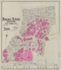
Jamaica Estates Queens Borough New York City.
1911 (dated) 31.5 x 28.25 in (80.01 x 71.755 cm) 1 : 2400
1911 (dated) 31.5 x 28.25 in (80.01 x 71.755 cm) 1 : 2400
Description
This 1911 map by Metropolis Engineering is the earliest map of Jamaica Estates, Queens, New York - the childhood home of former U.S. President Donald Trump. Today, as intended, Jamaica Estates, designed in the Garden City Ethic, remains one of the most attractive planned communities in New York. The map is signed by Albert Thomson, the architect behind many of the houses of Jamaica Estates, as well as the 71st Regiment Armory in Manhattan.
The map is signed by the Irish-American architect Albert Thomson (1871 - 1952), likely the former owner. Thomson is best remembered as the architect for the 71st Regiment Armory (demolished 1971) on Park Avenue in New York City, but also designed several of the original mansions of Jamaica Estates.
A Closer Look
Coverage of Jamaica Estates extends from Union Turnpike to Hillside Avenue, and from Home Lawn Avenue to Holliswood Avenue. Streets are illustrated, and properties are lotted, with the dimensions of each lot provided. There are two large private estates, designated as belonging to Morgan J. O'Brien (1852 - 1937), a prominent New York attorney, and Michael J. Degnon (1858 - 1925), builder of the New York City Subway - underscoring the degree to which Jamaica Estates attracted New York's most elite. Multiple lots are shaded purple, likely indicating they were complete and available for sale.The map is signed by the Irish-American architect Albert Thomson (1871 - 1952), likely the former owner. Thomson is best remembered as the architect for the 71st Regiment Armory (demolished 1971) on Park Avenue in New York City, but also designed several of the original mansions of Jamaica Estates.
Jamaica Estates
Development of Jamaica Estates began in 1907 when the Jamaica Estates Company, founded by Gustavus and Charles A. Meyer, contracted civil engineer Oscar Erlandsen and his Metropolis Engineering Company to develop the land. Metropolis was a new kind of Civil Engineering firm, focusing on developing whole neighborhoods and communities in accordance with practical and economic value systems - in this case, the Garden City Movement. The Meyers were inspired by the Garden City Movement of England, aiming to create a suburban community with open spaces and a high quality of living. Development took many years and remained in process until about 1915. Metropolis Engineering implemented winding roads, lavish landscaping, and large plots to promote exclusivity and privacy. The development attracted affluent residents with its serene and picturesque setting. Known today for distinctive Tudor-style architecture and meticulously maintained properties, Jamaica Estates remains one of the most desirable parts of New York City.Garden City Movement in New York
The Garden City Movement, although originating in England, found unique expression in New York, particularly in the early to mid-20th century. Influenced by Ebenezer Howard's (1850 - 1928) vision of harmonizing urban and rural living, several developments in and around New York attempted to embody these principles. Notable examples include Jamaica Estates, Sunnyside Gardens, and the planned communities of Radburn in New Jersey, which sought to create self-contained, balanced living environments. These areas featured well-designed housing, communal green spaces, and a layout prioritizing pedestrians over automobiles. While they didn't replicate Howard's model fully, these communities reflected Garden City ideals such as integrated land use, community cohesion, and a focus on the natural environment, setting a precedent for further suburban development ideologies.Publication History and Census
This map was created by the Metropolis Engineering Company and printed in 1911 by Robert A. Welcke. While there may have been earlier planning stage manuscript surveys, this is the earliest known map of Jamaica Estates. It was not soon surpassed, as evidenced by its use in a 1914 court case. This is the only known surviving example.Robert A. Welcke (November 24, 1848 - January 27, 1936) was a photolithographer active in New York in the latter part of the 19th century and early 20th century. Welcke was born in Wronke, today in Poland, but then part of Prussia. He emigrated to New York City in 1869. After settling, Welcke went into the lithography business with his brother, Edward Welcke, who arrived a decade earlier. After a split between the brothers during the economic depression of the late 1870s, Robert Welcke continued in business on his own. Welcke's firm, Robert A. Welcke Offset Company, was based at 176 William Street. His corpus ranges from real estate maps of New York and Connecticut to illustrations on Flemish Renaissance interiors to government maps and brochures to decorative sheet music covers. Following Welcke's death, the firm was taken over by his daughter, Olga Welcke, who, alongside William Jugens, managed it until the outbreak of World War II (1939 - 1945). Learn More...
Condition
Good. Light wear along original fold lines. Verso repairs to fold separations. Slight loss at a few fold intersections. Closed margin tears professionally repaired on verso. Closed tear extending .5 inch within printed area professionally repaired on verso.