This item has been sold, but you can get on the Waitlist to be notified if another example becomes available, or purchase a digital scan.
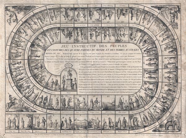
1815 Basset Jeux de L'Oie or Around the World Board Game
JeuInstructif-basset-1815
Title
1815 (undated) 19 x 25 in (48.26 x 63.5 cm)
Description
The games follows the traditional spiral form of the jeux de l'oie as established in Italy during the late 16th century. Most such games consist of 63 squares, a system derived from Kabalistic teachings, arranged in a spiral. Most squares represent progress towards an ultimate destination at the center of the board, square 63. Some squares involve hazards, bonuses, or penalties. These are standardized across most such boards, though vary in content. In the present example the board has the standard notable squares,
- 6. Traditionally a bridge, here represented by Mexico or Central America. Advance to square 12.
- 19. Traditionally an inn or hotel, here represented by the hospitable peoples of Tahiti. Wait 2 turns.
- 31. Traditionally a well, here represented by Siberia, a place of exile for Russians. Wait until another reaches this point and exchange places.
- 42. Traditionally a maze, here represented by Japan were navigators are refused entry. Return to square 39.
- 52. Traditionally a prison, here represented by enslavement on the Barbary Coast. Wait until another reaches this point and exchange places.
- 58. Traditionally death, here represented by being captured and eaten by the anthropophagi of New Zealand. Return to square 1.
Each game goes beyond simple cartographic representation to convey, through its rules or iconography, a deliberate 'message,' whether political, commercial or cultural. The games give insights into international relationships, perceptions and misconceptions at various points in the history of Europe. (Seville, A. The geographical Jeux de l'Oie of Europe, BELGEO, 2008 , 3-4)The present map is no exception. European squares are generally presented as superior to non-European squares, which, as we have seen above, may involve being eaten or enslaved. The ultimate destination is France, which is represented by an illustration of Henri IV, certainly a curious choice given that Napoleon had just been defeated. Certainly the mapmaker does not want to associate himself with the Revolutionary era and is instead harkening back to the glory days of the monarchy, as represented by the much admired Henry IV. Basset was, it seems, a Restoraitonist, or at least wanted to distance himself from the debacle of Napoleon's defeat. The numbers squares and vignettes are, as follows:
- China (Asia)
- Peru (South America)
- Hindustan (India)
- Lapland (Europe)
- England (Europe)
- Mexico (Central America) View the rope bridge.
- New Holland (Australia)
- Kamchatka (Asia)
- Russia (Europe)
- Guinea (Africa)
- Hottentots (Africa)
- Inhabitants edge of the River of the Amazons (South America)
- Jagos (Africa)
- Sweden (Europe)
- Greece (Asia)
- Cochin China (Asia)
- Greenland (Arctic Lands)
- Prussia (Europe)
- Otaheite Ile d '(South Sea) Islanders offer hospitality to the traveler
- Calmucks (Asia)
- Persia (Asia)
- Armenia (Asia)
- Germany (Europe)
- Saudi (Asia)
- Pegu (Asia)
- Tibet (Asia)
- Denmark (Europe)
- Siam (Asia)
- Egypt (Africa)
- Abyssinia (Africa)
- Siberia (Asia) Place of exile for Russians
- Switzerland (Europe)
- Nigritia (Africa)
- Iroquois (Amer. September)
- Caffres (Africa)
- Netherlands (Europe)
- Madagascar (Africa)
- Brazil (Amer. Merid)
- New Guinea (South Seas)
- Guiana (Amer. Merid)
- Hungary (Europe)
- Japan (Asia) Navigator denied entry
- Nubia (Africa)
- Tartars Cazan (Asia)
- Turkey (Europe)
- California (Amer. September)
- Chile (Amer. September)
- Korea (Asia)
- Great Tartary (Asia)
- Spain (Europe)
- Moluccas (Asia)
- Barbary (Africa) Traveler reduced to slavery
- Sumatra (Asia)
- Portugal (Europe)
- Java Island (Asia)
- Tierra del Fuego (Amer. Merid)
- Paraguay (Amer. Merid)
- New Zealand (Southern Lands) about to be eaten by cannibals
- Italy (Europe)
- Mogul Empire (Asia)
- Nootka Sound (Amer. Merid)
- Tschurtschi (Asia)
- France. 'Vive Henri IV, live the valiant King'
Cartographer
André Basset (Bassett; fl. 1768 - 1784) was a well-known French publisher and engraver active on the Rue St. Jacques, Paris, during the 18th and 19th centuries. His office was located at the corner of Rue Saint Jacques and of Mathurins, à l'enseigne de Sainte Geneviève. The firm is closely aligned with the Chéreau family of printers and engravers, with whom they were connected with multiple, often incestuous, marriages and remarriages. Basset was best known for the production of low-cost optical views of European cities and events. However, the firm also produced games, maps, and other prints. The firm was taken over by Paul-André Bassett (1759 - 1829) in 1784. Paul-André Bassett himself retired in 1819, but the business continued under various family members until 1865. More by this mapmaker...

