This copy is copyright protected.
Copyright © 2025 Geographicus Rare Antique Maps
Digital Image: 1840 QMG Manuscript Map of Kandahar, Afghanistan and its Immediate Environs
KandaharVillages-qmg-1840_d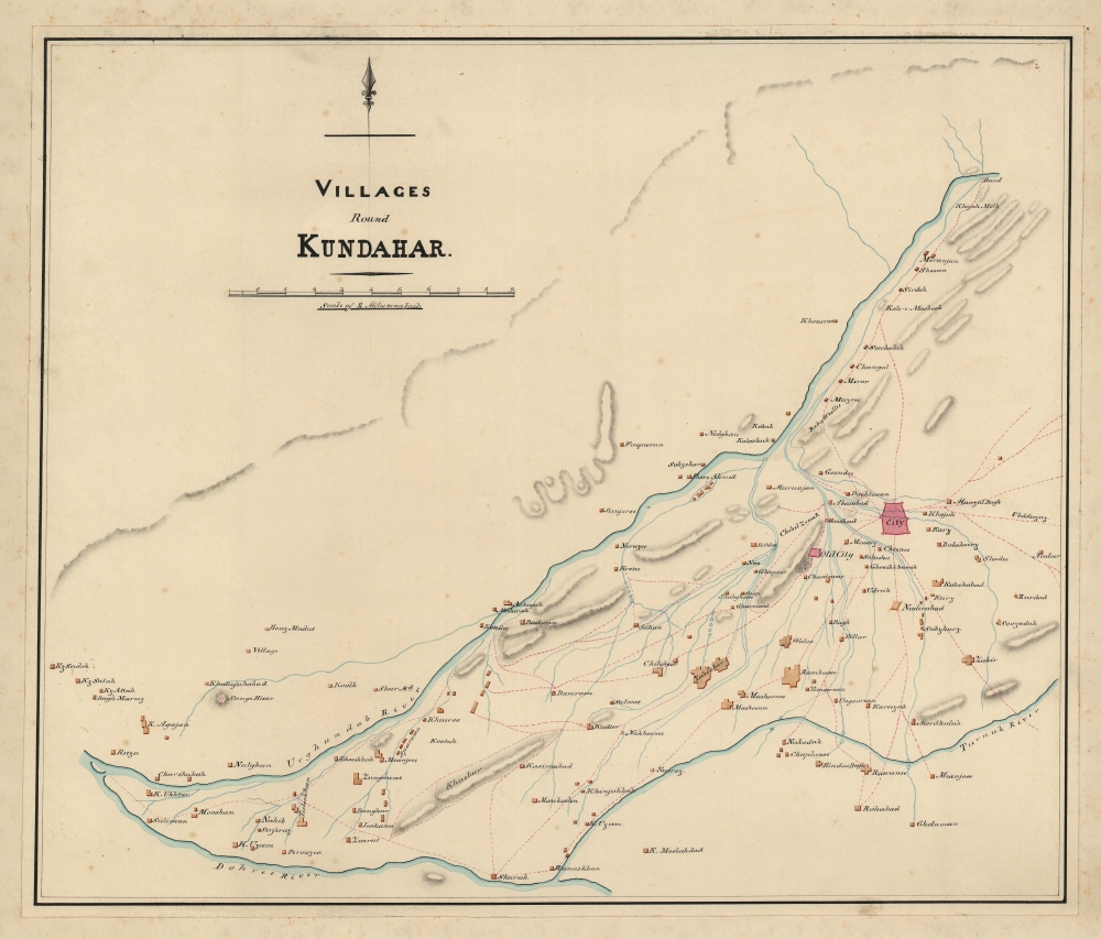

FOR THE ORIGINAL ANTIQUE MAP, WITH HISTORICAL ANALYSIS, CLICK HERE.
Digital Map Information
Geographicus maintains an archive of high-resolution rare map scans. We scan our maps at 300 DPI or higher, with newer images being 600 DPI, (either TIFF or JPEG, depending on when the scan was done) which is most cases in suitable for enlargement and printing.
Delivery
Once you purchase our digital scan service, you will receive a download link via email - usually within seconds. Digital orders are delivered as ZIP files, an industry standard file compression protocol that any computer should be able to unpack. Some of our files are very large, and can take some time to download. Most files are saved into your computer's 'Downloads' folder. All delivery is electronic. No physical product is shipped.
Credit and Scope of Use
You can use your digial image any way you want! Our digital images are unrestricted by copyright and can be used, modified, and published freely. The textual description that accompanies the original antique map is not included in the sale of digital images and remains protected by copyright. That said, we put significant care and effort into scanning and editing these maps, and we’d appreciate a credit when possible. Should you wish to credit us, please use the following credit line:
Courtesy of Geographicus Rare Antique Maps (http://www.geographicus.com).
How Large Can I Print?
In general, at 300 DPI, you should at least be able to double the size of the actual image, more so with our 600 DPI images. So, if the original was 10 x 12 inches, you can print at 20 x 24 inches, without quality loss. If your display requirements can accommodate some loss in image quality, you can make it even larger. That being said, no quality of scan will allow you to blow up at 10 x 12 inch map to wall size without significant quality loss. For more information, it is best consult a printer or reprographics specialist.
Refunds
If the high resolution image you ordered is unavailable, we will fully refund your purchase. Otherwise, digital images scans are a service, not a tangible product, and cannot be returned or refunded once the download link is used.
India Quartermaster General Office (1803 - 1947), a major branch of the QMG, was the division of the British Indian Army responsible for logistics and mapping. Among other duties, the QMG employed detachments of military engineers to conduct and compile surveys of conflict theaters. The QMG was based in Calcutta, but established several annex branches, in Simla (Himachal Pradesh, India), Colombo, and elsewhere. Master cartographers, surveyors, and draftsmen under the QMG traveled throughout British India and the adjacent regions, compiling detailed surveys in anticipation of trade, war, or both. Working in diverse and sometimes onerous conditions, they developed sophisticated cartographic conventions while at the same time adapting to local supplies and resources. Some, for example, have noted the QMG maps often have resplendent bright color - these are palettes adapted from Indian handmade watercolors traditionally used in the Bengali textile industry. These attractive colors were later adapted into the general British cartographic palette. Few QMG maps were ever published, most surviving only in manuscript, in institutional archives like the British Library’s India Office Records. Moreover, despite their significance, no comprehensive survey of surviving of India QMG maps has been compiled, resulting in their being generally underappreciated and misunderstood. The QMG remained active in India until the British withdraw in 1947. More by this mapmaker...
Copyright © 2025 Geographicus Rare Antique Maps | Geographicus Rare Antique Maps
This copy is copyright protected.
Copyright © 2025 Geographicus Rare Antique Maps