This copy is copyright protected.
Copyright © 2025 Geographicus Rare Antique Maps
Digital Image: 1967 Hayes Pictorial Map of Oregon
KeepOregonGreen-hayes-1967_d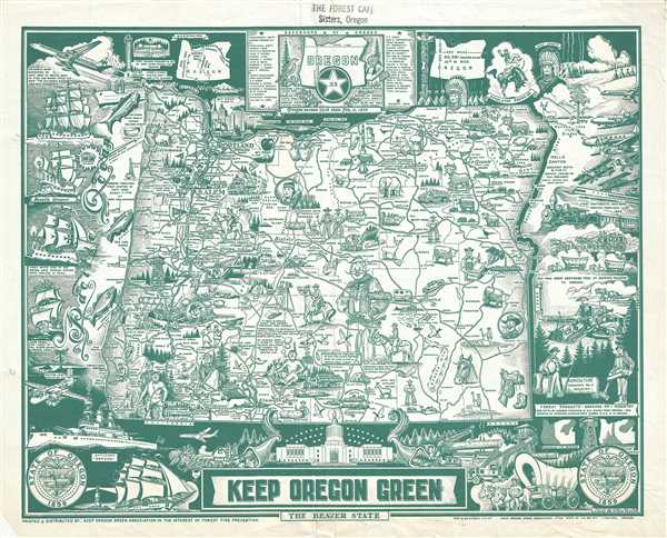

FOR THE ORIGINAL ANTIQUE MAP, WITH HISTORICAL ANALYSIS, CLICK HERE.
Digital Map Information
Geographicus maintains an archive of high-resolution rare map scans. We scan our maps at 300 DPI or higher, with newer images being 600 DPI, (either TIFF or JPEG, depending on when the scan was done) which is most cases in suitable for enlargement and printing.
Delivery
Once you purchase our digital scan service, you will receive a download link via email - usually within seconds. Digital orders are delivered as ZIP files, an industry standard file compression protocol that any computer should be able to unpack. Some of our files are very large, and can take some time to download. Most files are saved into your computer's 'Downloads' folder. All delivery is electronic. No physical product is shipped.
Credit and Scope of Use
You can use your digial image any way you want! Our digital images are unrestricted by copyright and can be used, modified, and published freely. The textual description that accompanies the original antique map is not included in the sale of digital images and remains protected by copyright. That said, we put significant care and effort into scanning and editing these maps, and we’d appreciate a credit when possible. Should you wish to credit us, please use the following credit line:
Courtesy of Geographicus Rare Antique Maps (http://www.geographicus.com).
How Large Can I Print?
In general, at 300 DPI, you should at least be able to double the size of the actual image, more so with our 600 DPI images. So, if the original was 10 x 12 inches, you can print at 20 x 24 inches, without quality loss. If your display requirements can accommodate some loss in image quality, you can make it even larger. That being said, no quality of scan will allow you to blow up at 10 x 12 inch map to wall size without significant quality loss. For more information, it is best consult a printer or reprographics specialist.
Refunds
If the high resolution image you ordered is unavailable, we will fully refund your purchase. Otherwise, digital images scans are a service, not a tangible product, and cannot be returned or refunded once the download link is used.
Hugh John Hayes Jr. (August 1, 1914 - June 25, 2013) was an American mapmaker, draftsman, and illustrator who spent most of his career working for the Oregon State Department of Forestry. Born in Bear Creek, Oregon, Hugh attended public schools in Wallowa, Washington, and graduated from high school in 1934. He then served in the Civilian Conservation Corps before finding a job as a draftsman with the Oregon State Board of Forestry in Salem, Oregon. During World War II, Hayes entered the U.S. Army on January 16, 1942, served in the 340th Engineer Regiment, and attained the rank of Master Sergeant. He spent sixteen months in Alaska and the Yukon Territory working on the construction of part of the Alaska-Canada Highway. While there, he also created maps, undertook surveys, and drew structural plans. Then he was transferred to the South Pacific, where he spent twenty-one months in Australia, New Guinea, Morotai, and Luzon designing bridges and drawing maps. After receiving an honorable discharge from the Army in November 1945, Hayes returned to the Oregon State Department of Forestry, where he worked until he retired in 1993. During his years at the Department of Forestry, Hayes illustrated field guides of Oregon trees, drew fire protection maps and safety cartoons, and designed plans for bridges and guard stations. Over the course of his career, Hayes also helped illustrated an entomology textbook for Oregon State University drew forest shrubs and plants for the Walt Disney movie 'Bambi.' Hayes married Florence Wilson Ruffner on May 14, 1957, and were married thirty-five years before she died of a heart attack in 1992. More by this mapmaker...
Copyright © 2025 Geographicus Rare Antique Maps | Geographicus Rare Antique Maps
This copy is copyright protected.
Copyright © 2025 Geographicus Rare Antique Maps