1953 J. K. van der Leeuw Pictorial KLM Royal Dutch Airlines Route Map of the World
KLMRouteItalian-vanderleeuw-1953$1,400.00


Title
KLM Su tutte le rotte del mondo.
1953 (undated) 25 x 39.25 in (63.5 x 99.695 cm)
1953 (undated) 25 x 39.25 in (63.5 x 99.695 cm)
Description
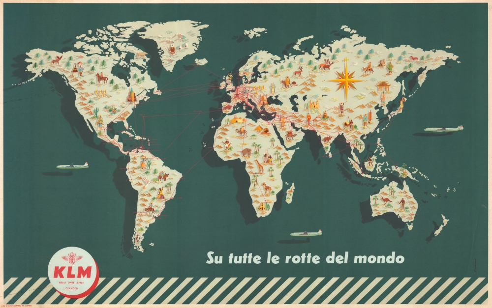
This is a dramatic c. 1953 J. F. van der Leeuw pictorial KLM Royal Dutch Airlines route map of the world. The map celebrates KLM's emergence as a leading international carrier in the wake of World War II (1939 - 1945).
A Closer Look
Pictorial illustrations highlight cities served by KLM and cultural aspects of cultures worldwide. Red lines and dots highlight KLM routes and the cities served: 6 continents and numerous cities, including New York, Mexico City, Caracas, Lima, Rio de Janeiro, Amsterdam, Istanbul, Cairo, Johannesburg, Beyrouth, Karachi, Bangkok, and Sydney via KLM flights. Landmarks, such as the Eiffel Tower, the Great Pyramid at Giza, and the Great Sphinx appear alongside locals in traditional clothing. Underscoring KLM's dedication to the most advanced aviation technology, a Lockheed Constellation flies east toward Asia; a Douglas DC-6 flies west toward Asia from the west coast of the United States; and another Douglas DC-6 flies between Australia and India in the southern Indian Ocean.Publication History and Census
This map was drawn by J. F. van der Leeuw for KLM Royal Dutch Airlines c. 1953. This map is not cataloged in OCLC, but we are aware of a few examples in institutional collections, including the National Air and Space Museum.Condition
Very good. Closed edge tears professionally repaired on verso. Edge wear.
References
Smithsonian National Air and Space Museum, Poster Collection.