This item has been sold, but you can get on the Waitlist to be notified if another example becomes available, or purchase a digital scan.
1805 Liechtenstern Map of the Kingdom of Hungary and the Grand Principality of Transylvania
KonigreicheUngarn-liechtenstern-1805$550.00

Title
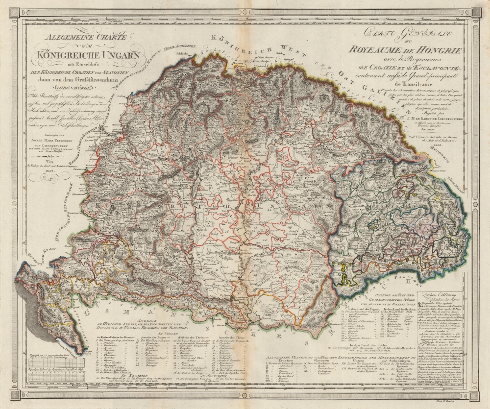
Allgemeine Charte vom Königreiche Ungarn mit Einschluss der Königreiche Croatien und Slavonien dann vom dem Grossfüstenthum Siebenbürgen. / Carte Générale du Royeaume de Hongrie avec les Royeaumes de Croatie et d'Esclavonie contenant aussi le Grand-principauté de Tansilvanie.
1805 (dated) 21 x 25 in (53.34 x 63.5 cm) 1 : 1500000
1805 (dated) 21 x 25 in (53.34 x 63.5 cm) 1 : 1500000
Description
This is an 1805 Joseph Marx von Liechtenstern map of the Kingdom of Hungary and the Grand Principality of Transylvania. The map and the rare Kipferling atlas it was published in were issued as a celebration and administrative tool for the consolidated Austrian Empire, declared in reaction to Napoleon's First French Empire during the Napoleonic Wars (1803 - 1815).
A Closer Look
The Kingdom of Hungary is highlighted in orange, the Grand Principality of Transylvania in blue, and the parts of Croatia and Slavonia in yellow. Along the bottom is a list of all the counties, districts, and regions in Hungary, Croatia, and Slavonia. Along the bottom on the right is a list of components of the military border between Croatia, Slavonia, Hungary, and Transylvania. A key in German and French occupies the lower right.Historical Context
In 1804, as this map was being prepared, in reaction to Napoleon's declaration of the First French Empire, Francis II proclaimed the Austrian Empire. This declaration theoretically unified Habsburg possessions under a central government. Nonetheless, the Kingdom of Hungary remained governed by their own King and Diet, as they had before the declaration. The Napoleonic Wars brought relative prosperity to most of the Kingdom of Hungary: their foodstuffs were sent to supply cities and armies, leading to infrastructure improvements in the transportation network and greater trade. After Napoleon's defeat, Hungary fell into a recession.Publication History and Census
This map was created by Joseph Marx Freyherrn von Liechtenstern, drawn by Franz Hœufler, and published in Vienna by Kunst und Industrie Comptoir. It is one of five maps prepared by Marx von Liechtenstern for the Atlas Des Österreichischen Kaiserthums. We note two examples cataloged in OCLC, which are part of the collections at Harvard University and Klassik Stiftung Weimar. An example is part of the collection at Charles University in Prague.Cartographer
Joseph Marx Freyherrn von Liechtenstern (February 12, 1765 - October 10, 1828) was an Austrian nobleman, geographer, and statistician. Coming from an elite family, he was well-educated, studying law before going into government service. He maintained a lifelong passion for geography, statistics, and comparative administration between states (political science avant le mot), and in 1790 founded the Vienna Kosmographische Institut ('Statistical Institute'). The upheavals of the era hampered the group's work; nonetheless, it did produce a steady stream of publications on history and geography, and promoted the use of statistics in public administration. Among other works, in contributed to and completed the influential 1805 Atlas Des Österreichischen Kaiserthums. More by this mapmaker...
Source
Kindermann, Karl, and Kipferling, Karl Joseph, and Marx von Liechtenstern, Jospeh, Atlas Des Österreichischen Kaiserthums, (Wien : Verlag des Kunst- und Industrie-Comptoirs) 1805.
Condition
Very good. Light toning and soiling along original centerfold.
References
OCLC 904895781, 248616853.