This item has been sold, but you can get on the Waitlist to be notified if another example becomes available, or purchase a digital scan.
1917 Rand McNally / Bentley Map of Lake George, New York, Military History
LakeGeorge-randmcnally-1917
Title
1917 (dated) 34 x 22 in (86.36 x 55.88 cm) 1 : 31680
Description
A Closer Look
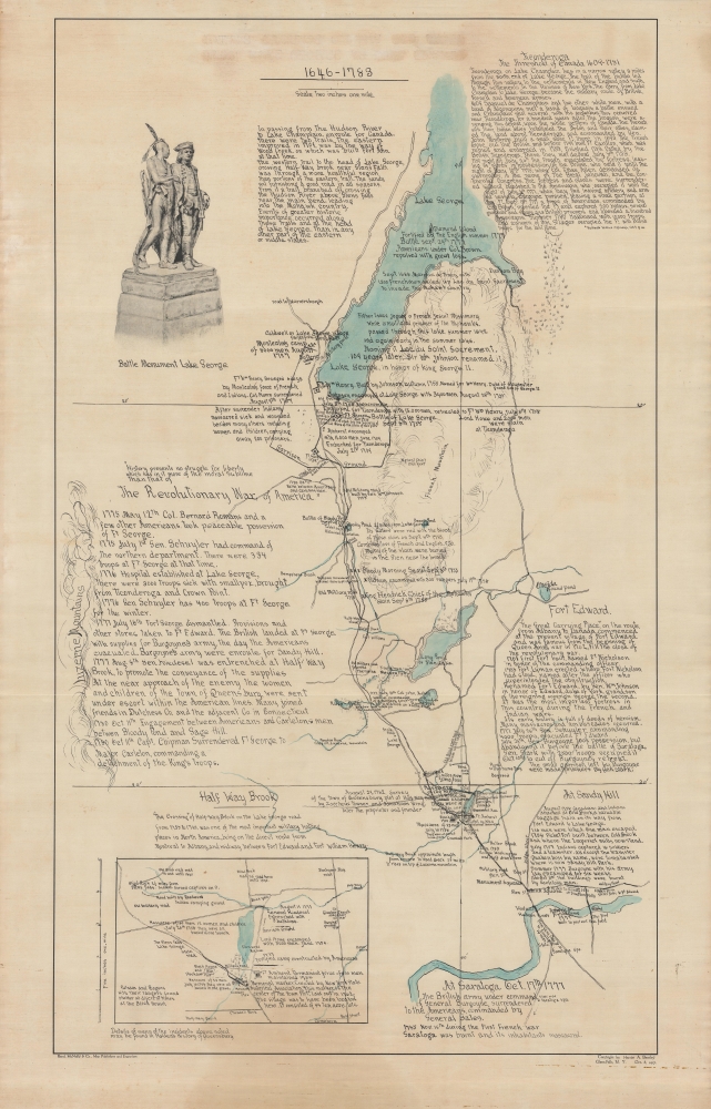
Although produced by the major firm Rand McNally, this map is unusual in that it was printed in a very small run, its historical notes printed to appear handwritten, on waxed linen rather than paper. This particular example is even more atypical in that the title has been blotted out.Coverage extends from Lake George south to what is now Glens Falls. The waterways, roads, and terrain are carefully noted, as are forts, garrisons, other fortifications, and the locations of battles. An inset map at bottom-left highlights Glens Falls, the site of multiple battles and massacres.
At top-left is an illustration of a monument erected in 1903 to commemorate the 1755 Battle of Lake George, which resulted in a British / Mohawk victory over the French / Abenaki alliance. In the statue, the Mohawk chief 'King Hendrick Theyanoguin' is providing advice to the British commander William Johnson. The statue sits near a site where Johnson's command tent was located.
A War-Ravaged Region
As indicated in the title, this map focuses on the area between the 18th century British Fort Edward, just to the southeast a bit further down the Hudson River from Glens Falls, and Fort William Henry, at the southern end of Lake George. These forts, part of a chain extending to Fort Ticonderoga on Lake Champlain, were the backbone of British control of New York, such as it was, and therefore became the inevitable focus of any French attempt to control the region. What is now Glens Falls, then just a rural hamlet, was important as it sat halfway between Fort Edward and Fort William Henry.As both the French and British were small in number and distracted by conflict in other parts of the world (the French and Indian War was the North American extension of the worldwide Seven Years' War), they relied on colonial militia and Native American allies to fill their ranks. Given the terrain, large battles in open country were rare, with ambushes, raids, and sieges of the forts more common. Animosities driven by colonial expansion and tensions between Native American groups led to numerous atrocities.
The conflict in Upstate New York mostly followed the general course of the war, in which the British fared poorly, suffering several disastrous defeats, but with superior numbers and resources were able to gain the upper hand over time. One exception was the Battle of Lake George in September 1755, technically a draw but in effect a British victory. After the battle, the British commander Johnson constructed Fort William Henry on Lake George. However, amid cautious planning and internal disagreements among the British, the French and their Indian allies seized the initiative. In August 1757, Fort William Henry was besieged by French and Indian forces and, with no relief in sight (despite a large British force stationed at Fort Edward), the defenders surrendered within days. For reasons that are still debated, after the British surrender some of the Indian allies of the French looted the fort and attacked the rear portion of the British prisoner column as well as civilians who sought protection at the fort. The incident became a rallying cry for the British and was later recounted in sensational accounts, including James Fenimore Cooper's 1826 novel The Last of the Mohicans, that drastically inflated the death toll.
The British launched a calamitous campaign in 1758 to invade Canada that failed when they were defeated by a much smaller French force just outside Fort Ticonderoga. Nevertheless, the French in North America were too low on men and supplies to press their gains, allowing the British to eventually prevail in the conflict.
This area again saw battles during the American Revolution. Though not as renowned or decisive as the American victory at Saratoga to the south, this region did see fighting during the Saratoga Campaign that preceded the decisive battle of the same name, as well as the movement of some troops (including General Washington) later in the conflict.
Publication History and Census
This map was drawn by Harriet A. Bentley, a local historian, and published by Rand McNally in 1917. Little is known about the author of this map, except that s/he published a book in 1927 titled The Old Military Road from Fort Edward to Lake George (OCLC 719852). We are only aware of two other examples of this map, held by the New York Historical Society and the Adirondack Experience Library in Blue Mountain Lake, New York, respectively.Cartographer
Rand, McNally and Co. (fl. 1856 - present) is an American publisher of maps, atlases and globes. The company was founded in 1856 when William H. Rand, a native of Quincy, Massachusetts, opened a print shop in Chicago. Rand hired the recent Irish immigrant Andrew McNally to assist in the shop giving him a wage of 9 USD per week. The duo landed several important contracts, including the Tribune's (later renamed the Chicago Tribune) printing operation. In 1872, Rand McNally produced its first map, a railroad guide, using a new cost effective printing technique known as wax process engraving. As Chicago developed as a railway hub, the Rand firm, now incorporated as Rand McNally, began producing a wide array of railroad maps and guides. Over time, the firm expanded into atlases, globes, educational material, and general literature. By embracing the wax engraving process, Rand McNally was able to dominate the map and atlas market, pushing more traditional American lithographic publishers like Colton, Johnson, and Mitchell out of business. Eventually Rand McNally opened an annex office in New York City headed by Caleb S. Hammond, whose name is today synonymous with maps and atlases, and who later started his own map company, C. S. Hammond & Co. Both firms remain in business. More by this mapmaker...


