1914 Southern Pacific Map of Land Grants in the Western United States
LandGrants-southernpacific-1914$450.00

Title
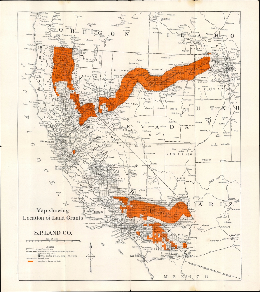
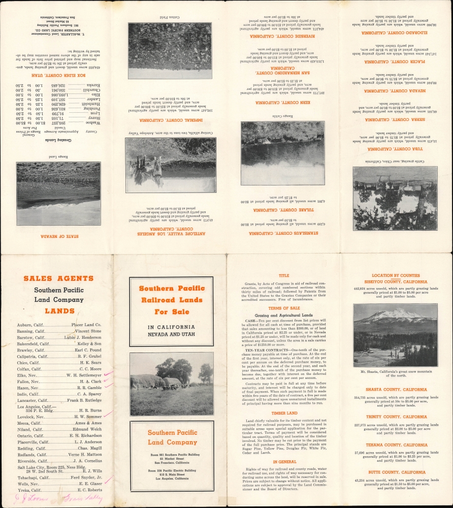
Map showing Location of Land Grants S.P. Land CO. / Southern Pacific Railroad Lands for Sale in California Nevada and Utah.
1914 (undated) 16.75 x 14 in (42.545 x 35.56 cm) 1 : 3600000
1914 (undated) 16.75 x 14 in (42.545 x 35.56 cm) 1 : 3600000
Description
A scarce c. 1914 map and pamphlet covering the Western United States demonstrating the land grants owned by the Southern Pacific Railroad in the early 20th century. It promotes the sale of lands held by the Land Company established by the railroad in California, Nevada, and Utah.
The Southern Pacific Land Company was created as a subsidiary of the railroad in the late 19th century to manage and often sell the railroad's remaining property. Over the following decades, more and more of the railroad's lands were transferred to the Land Company. These remaining lands were less desirable than grants that had already been sold off, and, as this pamphlet indicates, the railroad heavily promoted settlement in the San Joaquin, Antelope, and Imperial Valleys in California. These valleys had historically been too arid or lacked a consistent water supply suitable for farming but were made arable by irrigation projects in the late 19th century, resulting in an influx of settlers.
An increasingly important asset for the railroad at this time was also oil reserves lying under its lands; at the time of publication, the Southern Pacific Land Company owned more than 19 percent of all proven oil land in California. By the 1890s, Collis Huntington, one of the 'Big Four' who owned the Southern Pacific, estimated that the oil-producing land owned by the railroad far exceeded the value of all its other assets. In 1921, soon after this map's publication, the oil-producing land was spun off into its own subsidiary, the Pacific Oil Company, which was sold to the Tide Water Associated Oil Company in 1926.
A Closer Look
The map covers the Western United States, focusing on California, Nevada, and Utah, with portions of Oregon, Idaho, Arizona, and northern Mexico included. Grid lines mark out the land grants given by the U.S. Congress in the late 19th century to railroad companies, namely the Southern Pacific and the Central Pacific (owned, from 1885, by the Southern Pacific). As can be seen here, these grants constituted millions of acres of land. Lands for sale are shaded orange; most of these were in three groups: in far northern California (Shasta and Siskiyou Counties), inland Southern California (San Bernardino, Riverside, and Imperial Counties), and in a strip running between Utah near Promontory Point (where the Central Pacific and Union Pacific met in 1869, completing the Transcontinental Railroad) and Sacramento. In addition to the rail lines and land grants, cities and towns, county lines, surveying lines (meridians), and geographic features such as lakes and rivers are noted throughout. Promotional text on the verso discusses lands for sale divided by county, terms of sale, and sales agents in different locations throughout the West (with an additional one penciled in for Grass Valley, California).Railroads and Land Grants
Railroad land grants were a major government initiative in the mid-19th century designed to promote the construction of railroads and the settlement of the American West. Though much celebrated upon their completion, the economic logic for transcontinental railroads was scant, whereas the political and military logic for them was manifest. As a result, through a series of laws, the federal government (as well as territorial and state governments) provided an inducement to railroads by granting them tracts of land alongside the lines, in essence guaranteeing them future revenue as stations, towns, and farms cropped up along the rail lines. In order to provide some limitations on the future power of railroads, Congress instituted a 'checkerboard pattern' whereby the land grants were divided into equally sized blocks, with alternating blocks granted to the railroad or being retained by the government for future use, usually to be given to homesteaders. Although this system worked to quickly construct transcontinental and other long-distance railroads in the American West, the process was marred by widespread corruption, mismanagement by the railroads, and the displacement of Native Americans, including the violation of existing treaty terms to provide land grants to railroads.Southern Pacific Land Company
The management of granted land was a vital part of the operation and profitability of railroads, and, as one of the largest railroads in the American West, the Southern Pacific was no exception. In fact, the Southern Pacific Railroad was originally founded as a land-holding company aimed at connecting San Francisco with Los Angeles and San Diego by rail and, more importantly, to own the lands in between. The company was quickly acquired by California's 'Big Four' railroad entrepreneurs who had launched the Central Pacific Railroad (the western half of the first transcontinental railroad).The Southern Pacific Land Company was created as a subsidiary of the railroad in the late 19th century to manage and often sell the railroad's remaining property. Over the following decades, more and more of the railroad's lands were transferred to the Land Company. These remaining lands were less desirable than grants that had already been sold off, and, as this pamphlet indicates, the railroad heavily promoted settlement in the San Joaquin, Antelope, and Imperial Valleys in California. These valleys had historically been too arid or lacked a consistent water supply suitable for farming but were made arable by irrigation projects in the late 19th century, resulting in an influx of settlers.
An increasingly important asset for the railroad at this time was also oil reserves lying under its lands; at the time of publication, the Southern Pacific Land Company owned more than 19 percent of all proven oil land in California. By the 1890s, Collis Huntington, one of the 'Big Four' who owned the Southern Pacific, estimated that the oil-producing land owned by the railroad far exceeded the value of all its other assets. In 1921, soon after this map's publication, the oil-producing land was spun off into its own subsidiary, the Pacific Oil Company, which was sold to the Tide Water Associated Oil Company in 1926.
Publication History and Census
This map was produced by the Southern Pacific Land Company. It is undated, but T. McAllaster mentioned on the verso appears in some 1941 documents as the Land Commissioner of the Southern Pacific Railroad, which is likely the basis for that proposed date for the two examples recorded in the OCLC, held at Yale University and Columbia University. However, other details would suggest a significantly earlier date, such as the appearance of the Las Vegas and Tonopah Railroad, which was scrapped for metal during World War I (1914 - 1918), and the apparent presentation of the San Diego and Arizona Railway as under construction (it became operational in 1919).Condition
Good. Wear along original fold lines. Verso repair to a fold separation and slight loss at a few fold intersections. Writing on verso.
References
OCLC 54183767. White, R., Railroaded: The Transcontinentals And The Making Of Modern America (W. W. Norton, 2012). Daggett, S., Chapters on the History of the Southern Pacific (New York: The Ronald Press Company, 1922).


