This item has been sold, but you can get on the Waitlist to be notified if another example becomes available, or purchase a digital scan.
1859 Vuillemin Map of Asia
LAsie-vuillemin-1859$175.00

Title
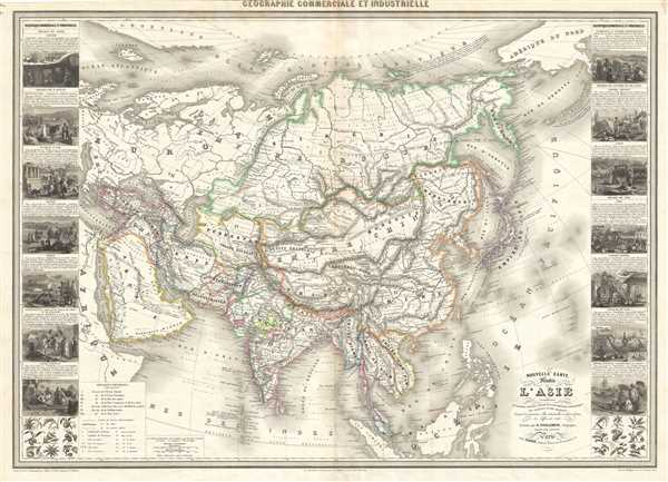
Nouvelle carte illustree de l'Asie.
1859 (dated) 25.5 x 35 in (64.77 x 88.9 cm) 1 : 20000000
1859 (dated) 25.5 x 35 in (64.77 x 88.9 cm) 1 : 20000000
Description
This is a beautiful large 1859 map of Asia by Alexandre Vuillemin. Covers the entire continent from Arabia eas as far as Kamchatka and from Siberia to the Malay Peninsula. Incredibly detailed, the map is color coded according to territories, with Tibet and Korea within the Borders of the Chinese Empire. The Great Wall of China is identified, as is Singapore. Throughout, Vuillemin identifies numerous cities, rivers, islands, mountains and other topographical features.
Along the left and right borders, the map includes 14 illustrations presenting scenes from various regions across Asia . These include scenes from Siberia, Transcaucasia, Turkey of Asia, Arabia, Persia, Afghanistan, Beloutchistan, Turkestan or independent Tartary, Chinese Empire, Japan, Indian, Burmese Empire, kingdom of Siam, Conchinchina and Tonkin. Two illustrations of the flora and fauna of the region is also included.
As this map was drawn, Imperial China wilted under the weak Qing Dynasty while the Russian Empire attained the height of its pan-continental expansion. Turkey and the Middle East were under Ottoman rule while the British Raj governed of India.
This map was engraved by Langevin and published by Alexandre Vuillemin in 1859.
Cartographer
Alexandre Aimé Vuillemin (1812 - 1880) was an engraver, publisher, and editor based in Paris, France in the middle of the 19th century. Despite a prolific publishing career, much of Vuillemin's life is shrouded in mystery. In 1852, he married Josephine Caroline Goret and they had at least one child, Ernestine Adèle Vuillemin, later in the same year. What is known is that his studied under the prominent French Auguste Henri Dufour (1798 - 1865). Vuillemin's most important work his detailed, highly decorative large format Atlas Illustre de Geographie Commerciale et Industrielle. More by this mapmaker...
Condition
Very good. Minor wear along original centerfold. Minor foxing.
References
OCLC: 606379545.