1970 Taylor Infographic Map of Los Angeles' Traffic
LATransportationSurvey-taylor-1970$350.00

Title
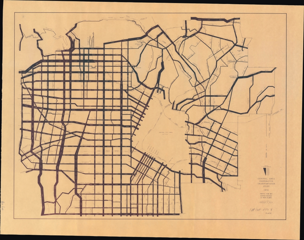
Traffic Flow Map Average Weekday 24 Hour Volumes. Preliminary Plate.
1970 (dated) 21.5 x 28 in (54.61 x 71.12 cm)
1970 (dated) 21.5 x 28 in (54.61 x 71.12 cm)
Description
An intriguing infographic map of Los Angeles traffic flows prepared in 1970 by City Traffic Engineer S. S. Taylor. It introduces a novel technique to illustrate traffic density and demonstrates the difficulty of managing the immense number of vehicles transiting the city daily.
Lines represent the traffic density in a weekday 24-hour period along major roads, with the thickest lines representing 40,000 vehicles or more. The most congested part of the city (outside of downtown, at least) was the entrance and exit of the Hollywood Freeway (U.S.-101) along Cahuenga Boulevard, Highland Avenue, and Franklin Avenue, where traffic could exceed 70,000 vehicles per day. Major north-south and east-west corridors such as La Cienega Boulevard, La Brea Avenue, Crenshaw Boulevard, Los Feliz Boulevard, Sunset Boulevard, and Wilshire Boulevard were also especially congested. Even the narrow and winding Laurel Canyon Boulevard far exceeds 20,000 vehicles per day.
Though the focus is on local roads (overseen by the city), state freeways and interstates are also traced with their (considerably larger) volume of vehicles, with the most congested part of the Santa Monica Freeway (Interstate-10) exceeding 230,000 vehicles.
In sum, this is a fascinating contemporary portrait of traffic congestion in Los Angeles that still rings true for anyone unfortunate enough to have extensive experience driving in the city.
A Closer Look
Coverage includes the area between Robertson Boulevard in the west and Indiana Street in the east and between Forest Lawn Drive (Griffith Park) and Colorado Boulevard in the north to Slauson Avenue in the south, except for the downtown portion of Los Angeles, which appeared on a separate map.Lines represent the traffic density in a weekday 24-hour period along major roads, with the thickest lines representing 40,000 vehicles or more. The most congested part of the city (outside of downtown, at least) was the entrance and exit of the Hollywood Freeway (U.S.-101) along Cahuenga Boulevard, Highland Avenue, and Franklin Avenue, where traffic could exceed 70,000 vehicles per day. Major north-south and east-west corridors such as La Cienega Boulevard, La Brea Avenue, Crenshaw Boulevard, Los Feliz Boulevard, Sunset Boulevard, and Wilshire Boulevard were also especially congested. Even the narrow and winding Laurel Canyon Boulevard far exceeds 20,000 vehicles per day.
Though the focus is on local roads (overseen by the city), state freeways and interstates are also traced with their (considerably larger) volume of vehicles, with the most congested part of the Santa Monica Freeway (Interstate-10) exceeding 230,000 vehicles.
In sum, this is a fascinating contemporary portrait of traffic congestion in Los Angeles that still rings true for anyone unfortunate enough to have extensive experience driving in the city.
Publication History and Census
This map was prepared by S. S. Taylor, L.A. City Traffic Engineer, in 1970, though it was not published until 1973, as part of a Central Area Cooperative Transportation Study. It is not independently cataloged with any institution, while the entire Study is only held by the University of California Los Angeles and the Los Angeles Public Library. 'Traffic Flow Maps' from later years are similarly scarce, listed among the holdings of a small handful of institutions (UCLA, LA Public Library, UC Berkeley, and the Metro Transportation Research Library and Archive) in the OCLC.Cartographer
Seymour Stillman Taylor (May 6, 1914 - March 7, 1977), often known as S.S., 'Signal Sam,' or simply 'Sam' Taylor, was the Los Angeles City Traffic Engineer within the Department of Traffic Engineering from 1958 to 1977. Taylor was born near Salt Lake City in Utah. He was tasked with traffic control measures in a period when the number of cars on L.A.'s streets increased significantly. Taking on the difficult role of managing traffic in such a sprawling metropolis, Taylor oversaw tens of thousands of traffic signals, stop signs, crosswalks, and other traffic control measures. He was an early advocate of a centralized electronic signal system for controlling traffic and adopted similar innovative measures to try to reduce congestion. At the same time, he was known for his stubbornness and frequently clashed with colleagues and elected officials, including L.A. mayors (one point of contention was that Taylor was deeply skeptical of various mass transit measures and high-occupancy vehicle lanes). He was widely regarded a leading expert in traffic control and was consulted by other American cities as well as those in foreign countries. Following Taylor's death in 1977, a new citywide Department of Transportation was created to integrate traffic control with other transportation-related tasks. More by this mapmaker...
Condition
Excellent. Some handwritten annotations.
References
OCLC 1336329491, 1195963289 (entire report).