1971 Taylor Infographic Map of Los Angeles' Traffic, Unbuilt Freeways
LATransportationSurvey-taylorss-1971$350.00

Title
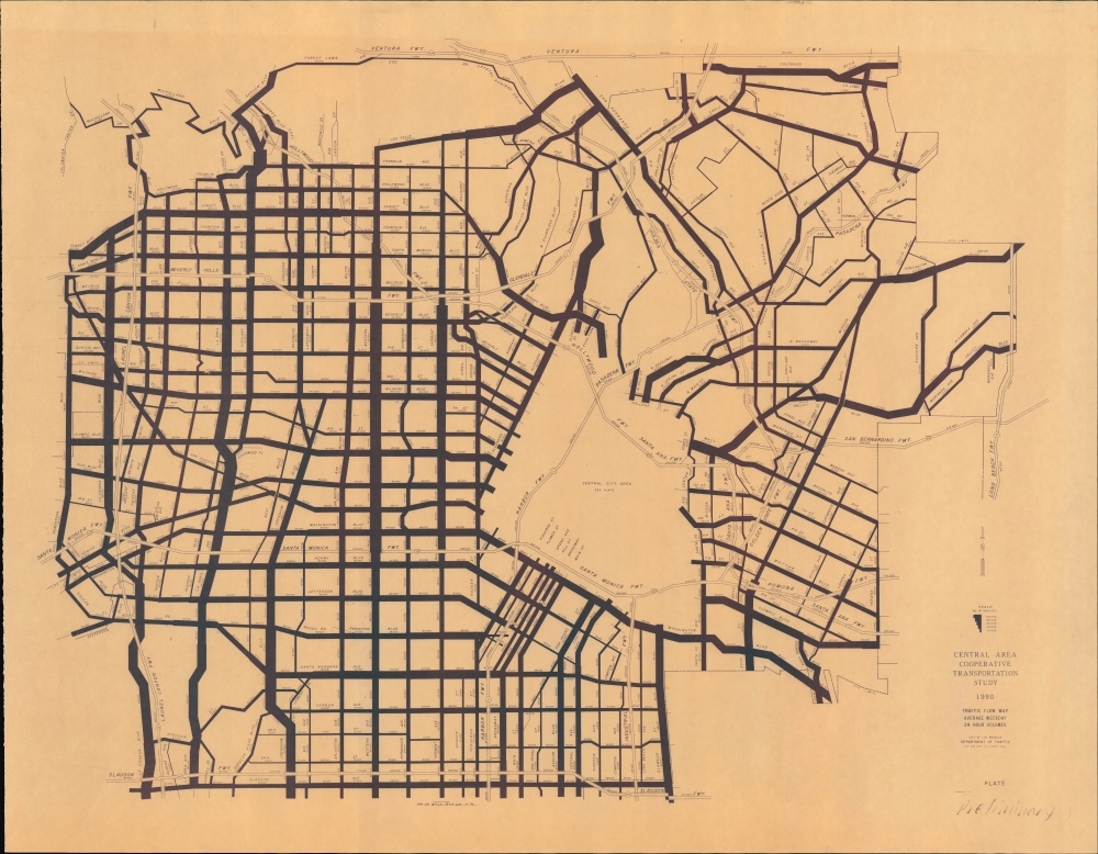
Traffic Flow Map Average Weekday 24 Hour Volumes. Preliminary Plate.
1971 (dated) 22 x 28.5 in (55.88 x 72.39 cm)
1971 (dated) 22 x 28.5 in (55.88 x 72.39 cm)
Description
An unusual 1971 infographic map of Los Angeles demonstrating expected daily traffic volume in 1990 prepared by City Traffic Engineer Samuel Taylor. It is notable for including the never-built Laurel Canyon, Beverly Hills, Slauson, and Industrial Freeways.
This map pairs with another traffic volume map prepared by Taylor around the same time (also sold by us) showing contemporary traffic flows. Here, however, daily traffic flows are projected forward to 1990. Lines represent the traffic density in a weekday 24-hour period along different major roads throughout the city, with the thickest lines representing 50,000 vehicles or more. The most congested part of the city (outside of downtown, at least) was the entrance and exit of the Hollywood Freeway (U.S.-101) along Cahuenga Boulevard, Highland Avenue, and Franklin Avenue, where traffic could exceed 80,000 vehicles per day. Major north-south and east-west corridors such as La Cienega Boulevard, La Brea Avenue, Crenshaw Boulevard, Los Feliz Boulevard, Sunset Boulevard, and Wilshire Boulevard, as well as the approach to the Glendale Freeway, were also especially congested.
Though the focus is on local roads (overseen by the city) state freeways and interstates are also traced with their (even larger) volume of vehicles. This map is unusual for including the Laurel Canyon, Beverly Hills, Slauson, and Industrial Freeways, along with a northward extension of the Long Beach Freeway seen at right here, which were proposed decades earlier in some cases but never built due to local opposition. Taylor, whose job was to improve traffic flow in the notoriously congested city, was a proponent of these projects (and a skeptic of mass transit). The impact of the proposed freeways not being built and that traffic being shifted to existing freeways and local roads is readily apparent (and, in fact, average daily traffic volumes on the existing freeways were much higher in 1990 than projected here). However, by the time this map was produced, the tide had turned against large-scale, centrally-planned projects that overrode the concerns of homeowners and neighborhoods.
A Closer Look
Coverage includes the area between Robertson Boulevard in the west and Indiana Street in the east and between Forest Lawn Drive (Griffith Park) and Colorado Boulevard in the north to Slauson Avenue in the south, except for the downtown portion of Los Angeles, which appeared on a separate map. An infographic as much as it is a map, consistent geographic scale is eschewed in order to cover most of the city.This map pairs with another traffic volume map prepared by Taylor around the same time (also sold by us) showing contemporary traffic flows. Here, however, daily traffic flows are projected forward to 1990. Lines represent the traffic density in a weekday 24-hour period along different major roads throughout the city, with the thickest lines representing 50,000 vehicles or more. The most congested part of the city (outside of downtown, at least) was the entrance and exit of the Hollywood Freeway (U.S.-101) along Cahuenga Boulevard, Highland Avenue, and Franklin Avenue, where traffic could exceed 80,000 vehicles per day. Major north-south and east-west corridors such as La Cienega Boulevard, La Brea Avenue, Crenshaw Boulevard, Los Feliz Boulevard, Sunset Boulevard, and Wilshire Boulevard, as well as the approach to the Glendale Freeway, were also especially congested.
Though the focus is on local roads (overseen by the city) state freeways and interstates are also traced with their (even larger) volume of vehicles. This map is unusual for including the Laurel Canyon, Beverly Hills, Slauson, and Industrial Freeways, along with a northward extension of the Long Beach Freeway seen at right here, which were proposed decades earlier in some cases but never built due to local opposition. Taylor, whose job was to improve traffic flow in the notoriously congested city, was a proponent of these projects (and a skeptic of mass transit). The impact of the proposed freeways not being built and that traffic being shifted to existing freeways and local roads is readily apparent (and, in fact, average daily traffic volumes on the existing freeways were much higher in 1990 than projected here). However, by the time this map was produced, the tide had turned against large-scale, centrally-planned projects that overrode the concerns of homeowners and neighborhoods.
Publication History and Census
This map was prepared by Los Angeles City Traffic Engineer Samuel Taylor and drawn by 'H. Campbell' in November 1971 (in tiny print above the word 'Preliminary' at bottom-right). It may have been published with the 1973 report Central Area Cooperative Transportation Study. The map is not independently cataloged with any institution, and the entire Study is only held by the University of California Los Angeles and the Los Angeles Public Library.Cartographer
Seymour Stillman Taylor (May 6, 1914 - March 7, 1977), often known as S.S., 'Signal Sam,' or simply 'Sam' Taylor, was the Los Angeles City Traffic Engineer within the Department of Traffic Engineering from 1958 to 1977. Taylor was born near Salt Lake City in Utah. He was tasked with traffic control measures in a period when the number of cars on L.A.'s streets increased significantly. Taking on the difficult role of managing traffic in such a sprawling metropolis, Taylor oversaw tens of thousands of traffic signals, stop signs, crosswalks, and other traffic control measures. He was an early advocate of a centralized electronic signal system for controlling traffic and adopted similar innovative measures to try to reduce congestion. At the same time, he was known for his stubbornness and frequently clashed with colleagues and elected officials, including L.A. mayors (one point of contention was that Taylor was deeply skeptical of various mass transit measures and high-occupancy vehicle lanes). He was widely regarded a leading expert in traffic control and was consulted by other American cities as well as those in foreign countries. Following Taylor's death in 1977, a new citywide Department of Transportation was created to integrate traffic control with other transportation-related tasks. More by this mapmaker...
Condition
Very good.
References
Division of Traffic Operations, 1990 Traffic Volumes on California State Highways (Sacramento: California Department of Transportation, 1990).