This item has been sold, but you can get on the Waitlist to be notified if another example becomes available, or purchase a digital scan.
1900 Scott-Elliot Set of 2 World Maps illustrating Mythical Lemuria
Lemuria-scottelliot-1904$475.00

Title
Lemuria at its Greatest Extent. / Lemuria at a Later Period.
1904 (undated) 14 x 18 in (35.56 x 45.72 cm) 1 : 105000000
1904 (undated) 14 x 18 in (35.56 x 45.72 cm) 1 : 105000000
Description
An intriguing set of 2 maps, c. 1904, tracing the rise and fall of the lost civilization of Lemuria based upon the writings of William Scott-Elliot and the clairvoyant visions of Charles Webster Leadbeater. The maps underscore the late 19th and early 20th-century obsession with Lemuria, Atlantis, and all things 'mystical,' as well as the need to contextualize 'clairvoyant' visions with history and science.
A Closer Look
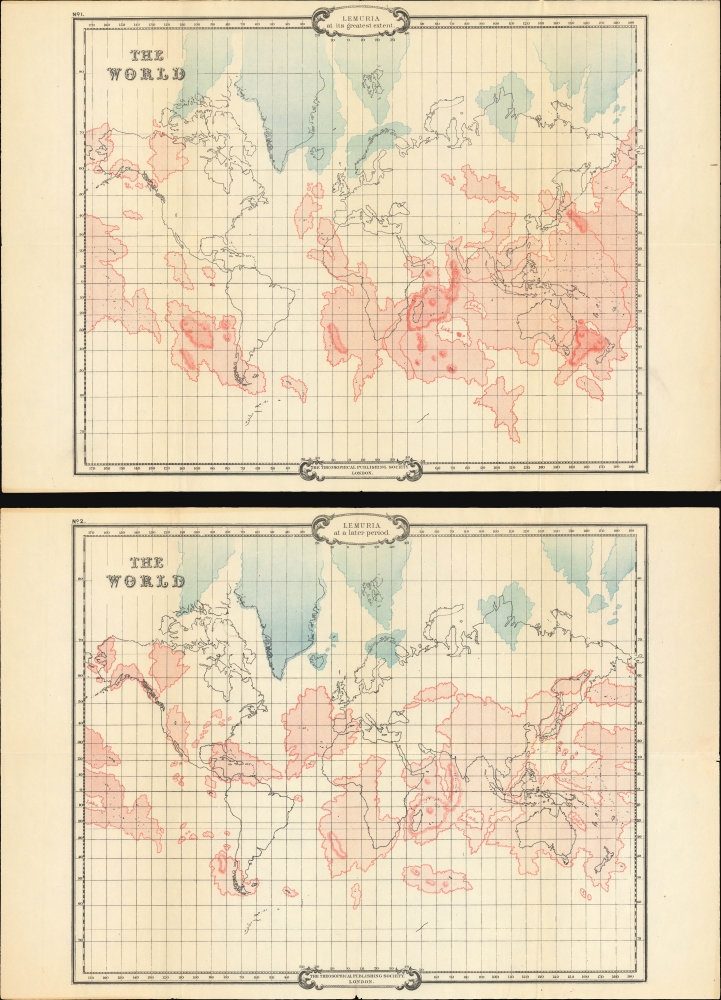
The set consists of two 'historical' world maps representing the Earth's configuration at different historical periods. The first covers the Permian (299 - 251 million years ago), through the Triassic (252 - 201 million years ago), and into the Jurassic (199.6 - 145.5 million years ago). The second represents the Earth's configuration through the Cretaceous (145 - 66 million years ago) and into the Eocene (55.8 - 33.9 million years ago). The maps feature red and blue continental masses superimposed over an outline Mercator projection. Red represents Lemuria, while blue indicates the remains of the proto-continent of Hyperborea (including the lost Lemuria). Lemuria, posits Scott-Elliot, was a precursor to Atlantis, the latter having been settled by the 'Third Lemurian Root Race.'Contextualizing Esoterism
These works are based on Scott-Elliot's attempts to bring 'scientific', 'historical', and 'religious' context to the clairvoyant visions of Theosophist Charles Webster Leadbeater. Much of Scott-Elliot's work is based upon the earlier fringe writings of Ignatius Loyola Donnelly, an American politician, conman, and pseudo-scientist whose 1882 work, Atlantis: The Antediluvian World, popularized the modern conceptualization of Atlantis. We put both 'scientific' and 'historical' in quotes, as both authors were attempting to combine new scientific and archeology discoveries, existing historical suppositions, outlandish anthropological and ethnological theories, religion, and the then-nascent occultist stream of Western esotericism.Lemuria
Lemuria is a mythical lost continent proposed in the 19th century to explain similarities in fossils found in India and Madagascar, particularly those of lemurs. The idea was first suggested by zoologist Philip Sclater in 1864, who theorized that a sunken landmass once connected these regions, allowing species to migrate. Although the concept gained traction in scientific circles for a time, it was eventually debunked with the advent of plate tectonics, which provided a more accurate explanation for species distribution. Despite this, Lemuria was adopted by various occult and esoteric traditions, where it was depicted as an advanced ancient civilization akin to Atlantis that met with a catastrophic end.Scott-Elliot Describes His Maps
We'll let Scott-Elliot describe these maps:From the older of the two maps it may be seen that the equatorial continent of Lemuria at the time of its greatest expansion nearly girdled the globe, extending as it then did from the site of the present Cape Verd Islands a few miles from the coast of Sierra Leone, in a south-easterly direction through Africa, Australia, the Society Islands and all the intervening seas, to a point but a few miles distant from a great island continent (about the size of the present South America) which spread over the remainder of the Pacific Ocean, and included Cape Horn and parts of Patagonia.
A remarkable feature in the second map of Lemuria is the great length, and at parts the extreme narrowness, of the straits which separated the two great blocks of land into which the continent had by this time been split, and it will be observed that the straits at present existing between the islands of Bali and Lomboc coincide with a portion of the straits which then divided these two continents. It will also be seen that these straits continued in a northerly direction by the west, not by the east coast of Borneo, as conjectured by Ernst Haeckel.
Publication History and Census
These maps were drawn by Scott-Elliot and published by the Theosophical Publishing House, London. The book in which it was published, The Lost Lemuria was first issued in 1904. Subsequent issues by the Theosophical Press followed until about 1925, all containing the present maps. It is impossible to determine which edition the maps came from as paper and printing are near identical. We see 9 examples of the 1904 edition in OCLC.Cartographer
William Scott-Elliot (March 24, 1849 - September 2, 1919) was a Scottish nobleman, merchant banker, theosophist, and amateur historian. Scott-Elliot was born in Edinburgh and inherited the title of Laird of Arkleton. He attended the Rugby School, in Edinburgh, before going on to a career in London with the banking firm Wallace Brothers. He was an early member of the London Lodge of the Theosophical Society and is today best known for his accounts of the lost continents of Atlantis and Lemuria, based on the clairvoyant visions of Charles Webster Leadbeater (1847 - 1934). More by this mapmaker...
Source
Scott-Elliot, W., The Lost Lemuria with Two Maps Showing ... Distribution Of Land Areas At Different Periods, (London: Theosophical Publishing) c. 1904.
Condition
Very good. Slight wear on old fold lines.
References
OCLC 486606.