1875 Jordan / Petermann Map of the Rohlfs Expedition, Egyptian and Libyan Deserts
LibyaRohlfs-petermann-1875$500.00

Title
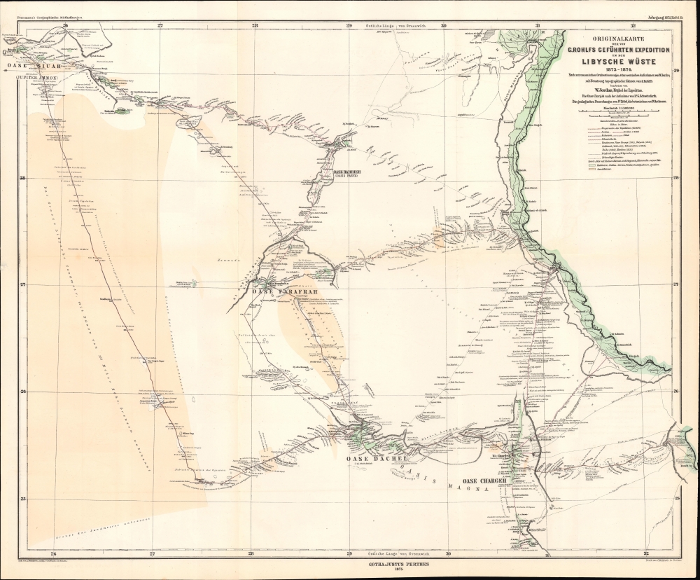
Originalkarte der von G. Rohlfs geführten Expedition in die Libysche Wüste, 1873 - 1874.
1875 (dated) 17.5 x 21.75 in (44.45 x 55.245 cm) 1 : 1300000
1875 (dated) 17.5 x 21.75 in (44.45 x 55.245 cm) 1 : 1300000
Description
A fascinating map of the deserts of western Egypt and eastern Libya, tracing the routes of the 1873 - 1874 Rohlfs Expedition, drawn by the expedition's surveyor Wilhelm Jordan. It is one of the few, and perhaps the first, early maps to detail the desert oases of western Egpyt. Today, the Siwa, Bahariya, Farafra, Dakhla-Kharga Route is a possible if rugged circuit for the adventurous traveler.
Between 1865 and 1867, Rohlfs disguised himself as an Arab and crossed the Sahara and much of the continent, from Tripoli to Lake Chad and on to Lagos. He was feted on his return to Europe by the leading geographers of the day, including receiving the Patron's Medal of the Royal Geographical Society of London. The following years saw additional travels, including the 1873 - 1874 expedition seen here.
The group included numerous well-known German scientists, including geologist Karl Alfred von Zittel (1839 - 1904), botanist Paul Ascherson (1834 - 1913), and surveyor Wilhelm Jordan (see biography below), who, as can be seen, split off from the main group at various points. One focus of the expedition was the exploration of the Dakhla Oasis and its numerous archaeological sites, as well as the flora and fauna of the oasis and the excavation and documentation of the Deir el-Hagar temple. Another special feature was the engagement of the photographer Philipp Remelé (1844 - 1883). Remelé took over 150 photographs of the oasis and its inhabitants and was commissioned by Rohlfs to excavate the temple of Deir el-Hagar. In addition to Rohls, who wrote a comprehensive account of the expedition and a shorter, more accessible synopsis (in collaboration with his colleagues), Zittel, Ascherson, Jordan, and Remelé published works in the following years based on their observations during the expedition, winning acclaim in their respective fields.
A Closer Look
The map displays a portion of southern Egypt and southeastern Libya, between the Nile (shaded green at right) and the Kufra Oases (the string of oases in the Libyan Desert at left here). Areas of elevation, routes through the desert, settlements, oases, sand dunes, areas of cultivation, and other features are labeled throughout. The progress of the various routes of the expedition is traced with dates, as explained in the legend at right. The routes of earlier European explorers are also recorded. Information is provided on local landmarks, flora, and other markers.Friedrich Gerhard Rohlfs and the Exploration of North Africa
Over his career, Rohlfs played a major role in the European exploration of North Africa and the Sahara Desert. Trained as a physician, Rohlfs served as a military doctor, eventually joining the French Foreign Legion. He quickly gained various awards, including being made a Chevalier of the Legion of Honor, and learned Arabic during his travels with the Legion. In 1861, he moved to Morocco and began exploring desert oases, being severely injured and almost killed on one such foray. The experience and his long recovery did not deter Rohlfs, who in 1864 crossed the Atlas Mountains to Tuat, providing the first map and description of the region to Europeans.Between 1865 and 1867, Rohlfs disguised himself as an Arab and crossed the Sahara and much of the continent, from Tripoli to Lake Chad and on to Lagos. He was feted on his return to Europe by the leading geographers of the day, including receiving the Patron's Medal of the Royal Geographical Society of London. The following years saw additional travels, including the 1873 - 1874 expedition seen here.
The 1873 - 1874 Expedition
Rohlfs' 1873 - 1874 expedition was a much larger and more public undertaking that his previous explorations. With the financial support of Isma'il Pasha (r. 1863 - 1879), the khedive of Egypt, Rohlfs was accompanied by dozens of men and camels carrying some 500 metal water canisters to explore the oases of western Egypt and Libya. Convening in Alexandria in late November 1873, the team set out from the Nile at Asyut (Siut here) towards the Western Desert, looking for a direct route to the Kufra Oases. The party ran into various troubles, including massive, insurmountable sand dunes. In the end, the expedition had to deviate from the planned route to reach Siwa (Siuah), unable to explore or traverse the sand dunes (the area labeled 'grenze des sanders unbekannt'), known in English as the Great Sand Sea. Nevertheless, in scientific terms, Rohlfs' 1873 - 1874 expedition was significant and successful.The group included numerous well-known German scientists, including geologist Karl Alfred von Zittel (1839 - 1904), botanist Paul Ascherson (1834 - 1913), and surveyor Wilhelm Jordan (see biography below), who, as can be seen, split off from the main group at various points. One focus of the expedition was the exploration of the Dakhla Oasis and its numerous archaeological sites, as well as the flora and fauna of the oasis and the excavation and documentation of the Deir el-Hagar temple. Another special feature was the engagement of the photographer Philipp Remelé (1844 - 1883). Remelé took over 150 photographs of the oasis and its inhabitants and was commissioned by Rohlfs to excavate the temple of Deir el-Hagar. In addition to Rohls, who wrote a comprehensive account of the expedition and a shorter, more accessible synopsis (in collaboration with his colleagues), Zittel, Ascherson, Jordan, and Remelé published works in the following years based on their observations during the expedition, winning acclaim in their respective fields.
Publication History and Census
This map was originally drawn by Wilhelm Jordan, surveyor of the Rohlfs Expedition, and was engraved by Carl Hellfarth for publication in the 1875 edition of Petermann's geographische Mitteilungen, accompanying an article written by Jordan discussing the expedition. The map is independently cataloged among the holdings of eight institutions in the OCLC, though outside of Europe only at the Library of Congress and University of Chicago, while the entire 1875 volume of Petermann's geographische Mitteilungen is more widely distributed.CartographerS
Wilhelm Jordan (March 1, 1842 - April 17, 1899) was a German surveyor and cartographer who played a key role in developing the field of geodesy in Germany. He founded departments of surveying at the universities of Hanover and Karlsruhe and wrote a well-regarded multi-volume textbook titled at the universities of Hanover and Karlsruhe. Jordan studied surveying and civil engineering at the Polytechnikum Stuttgart (now University of Stuttgart), completing his studies in 1863. He began to establish a name as an authority in the field of surveying, writing textbooks and teaching at Karlsruhe. He acted as surveyor for the 1873 - 1874 Libyan Expedition of Friedrich Gerhard Rohlfs, which helped to gain him greater acclaim in the surveying profession. For the remainder of his career, Jordan focused on teaching, mentoring students, and reshaping the training of surveyors in Germany, leaving a deep mark on the field for years to come. More by this mapmaker...
August Heinrich Petermann (1822 - 1878) was a German cartographer. Petermann attended the 'Geographische Kuntschule' (Geographica School of Art), which was started by Heinrich Berghaus with the support of Alexander von Humboldt, in Potsdam beginning in 1839. Students at the school were obliged to work on many of the school's contracts, including maps for several different atlases. Following his time in Potsdam, Petermann relocated to Edinburgh and London from 1845 to 1854, where he gained insight into the commercial aspects of the cartography business. In 1854, Petermann returned to Gotha, Germany and began working with the Perthes brothers publishers. While working with the Perthes brothers, Petermann founded the journal Petermanns Geographische Mitteilungen, published from 1855 until 2014, long one of the most prominent German-language geography journals. Learn More...
Carl Hellfarth (November 30, 1846 - July 12, 1918) was a German printer. Hellfarth was born in Gotha, Germany. He married Amalie Friederike Marie Möller (1850 - 1916) on June 16, 1873, and they had eight children. Learn More...
Johan Georg Justus Perthes (September 11, 1749 - May 2, 1816) was one of the most important German cartographic engravers of the 19th century. He was born in the Thuringian town of Rudolstadt, the son of a court physician. In 1778, he began working as a bookseller in Gotha. Perthes began his publishing empire shortly thereafter with the 1784 issue of the famed survey of European nobility known as the Almanac de Gotha. In the next year, 1785, he founded the cartographic firm of Justus Perthes Geographische Anstalt Gotha. His son Wilhelm Perthes (1793 - 1853) joined the firm in 1814. Wilhelm had prior publishing experience at the firm of Justus Perthes' nephew, Friedrich Christoph Perthes, who ran a publishing house in Hamburg. After Justus Perthes died in 1816, Wilhelm took charge and laid the groundwork for the firm to become a cartographic publishing titan. From 1817 to 1890. the Perthes firm issued thousands of maps and more than 20 different atlases. Along with the visionary editors Hermann Berghaus (1797 - 1884), Adolph Stieler (1775 - 1836), and Karl Spruner (1803 - 1892), the Perthes firm pioneered the Hand Atlas. When Wilhelm retired, management of the firm passed to his son, Bernhardt Wilhelm Perthes (1821 – 1857). Bernhardt brought on the cartographic geniuses August Heinrich Peterman (1822 - 1878) and Bruno Hassenstein (1839 - 1902). The firm was subsequently passed to a fourth generation in the form of Berhanrd Perthes (1858 – 1919), Bernhard Wilhelm's son. The firm continued in the family until 1953 when, being in East Germany, it was nationalized and run as a state-owned enterprise as VEB Hermann Haack Geographisch-Kartographische Anstalt Gotha. The Justus family, led by Joachim Justus Perthes and his son Wolf-Jürgen Perthes, relocated to Darmstadt where they founded the Justus Perthes Geographische Verlagsanstalt Darmstadt. Learn More...
Source
Jordan, W., 'Dr. G. Rohlfs Expedition in die Libysche Wüste 1873–74. Erläuterungen zu der Originalkarte' in Petermann's geographische Mitteilungen, v. 21 (Gotha: Petermann) 1875.
Petermanns Geographische Mitteilungen (March 16, 1855 - 2004) was a German-language geographical journal published by Justus Perthes in Gotha. Founded by August Heirich Petermann (April 18, 1822 - September 25, 1878), a German cartographer, Petermanns Geographische Mitteilungen was the oldest German-language journal of geography. A considerable part of the journal in the 1890s were accounts written by missionaries from all over the world. It also published exclusive research reports and cartographic material.
Condition
Very good. Light wear along original folds. Several small tears along border professionally repaired.
References
OCLC 166398004.