1736 / 1798 Charpentier / Jean Panorama of Lisbon, Portugal
Lisbon-charpentier-1736$1,250.00

Title
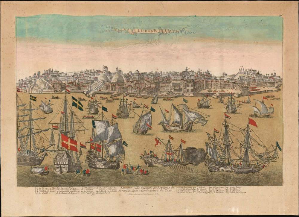
Lisbone / Lisbone, Ville Capitale du Royaume de Portugal, située à l'Embouchure du Tage.
1736 (undated) 13.75 x 20.5 in (34.925 x 52.07 cm)
1736 (undated) 13.75 x 20.5 in (34.925 x 52.07 cm)
Description
This lively, attractive waterfront panorama of Lisbon, engraved by Étienne Charpentier around 1736, captures the bustling capital of Portugal just shy of 20 years before the city was destroyed in the cataclysmic 1755 earthquake and tsunami.
In the end, 85% of the city was in ruins, and some 40,000 people (of the city's 200,000) died. The famed palaces and libraries were destroyed, including the Royal Archives, which housed hundreds of priceless paintings by the great masters of Europe. Also lost, and of note to us, were all the records of early Portuguese navigation, including those of Vasco de Gama, Pedro Álvares Cabra, and Bartolomeu Dias.
In an instant, the thriving Portuguese economy collapsed. Having struck on a religious holiday, many staunch Catholics believed the quake to be divine wrath. The earthquake also had a wide-ranging impact on philosophy and literature throughout Europe. It was used by some to argue against the notion of a benevolent deity. Politically, the aftermath precipitated a consolidation of power in the hands of the king and the fall of many of Portugal's long-standing noble families.
A Closer Look
This image is likely based on the view of the same title by Antoine Aveline (1691 - 1743) but is a different engraving. This north-oriented view presents the waterfront and heights of the city as viewed across the mouth of the Tagus. The river is teeming with ships - merchant vessels, warships, fishing boats, galleys, and longboats shuttling people and goods back and forth from ships at anchor. The scene emphasizes the importance of the sea to Portuguese power. The prospect of the city shows a wealth of structures - castles, palaces, churches, and cathedrals - 28 of which are numbered and keyed to a legend at the bottom of the view. Numbers 13 and 15, assigned on the legend to Lisbon's main shipyard and to the Church of Saint Roch, respectively, are accidentally swapped, with the shipyard receiving Saint Roch's number and vice versa. (The error is easily spotted: Saint Roch was the first Portuguese Jesuit church, situated on the heights above the city: the shipyard can be identified by its place directly on the waterfront and the ships under construction there.) While Saint Roch would survive the earthquake of 1755 relatively intact, most of the structures visible in the view here would be destroyed in the disaster, including the Royal Palace, the ducal palace, and the magnificent Corte Real Palace next to the shipyard.Great Lisbon EarthquakeIn 1755, Lisbon was at the height of its Golden Age. Portuguese ships sailed from Lisbon to all parts of the world: its colonies in Brazil, Macao, India, and Africa. Monarchs lavished wealth on their capital, making it a city of soaring cathedrals and palaces. Then, the Portuguese Golden Age came crashing to an end on November 1, 1755, when a massive earthquake (7.7 Richter Scale) devastated Lisbon. Fleeing collapsing buildings, the populace fled to open spaces, only to watch the sea recede, destroying all ships and cargo in the harbor. Forty minutes later, three massive tsunamis crashed into the already devastated city. As November 1 was All Saints Day, devotional candles throughout the city were toppled, leading to a firestorm of such magnitude that it asphyxiated people up to 30 meters from the flames.In the end, 85% of the city was in ruins, and some 40,000 people (of the city's 200,000) died. The famed palaces and libraries were destroyed, including the Royal Archives, which housed hundreds of priceless paintings by the great masters of Europe. Also lost, and of note to us, were all the records of early Portuguese navigation, including those of Vasco de Gama, Pedro Álvares Cabra, and Bartolomeu Dias.
In an instant, the thriving Portuguese economy collapsed. Having struck on a religious holiday, many staunch Catholics believed the quake to be divine wrath. The earthquake also had a wide-ranging impact on philosophy and literature throughout Europe. It was used by some to argue against the notion of a benevolent deity. Politically, the aftermath precipitated a consolidation of power in the hands of the king and the fall of many of Portugal's long-standing noble families.
Publication History and Census
The plate was drawn by an anonymous artist and engraved in Paris by Étienne Charpentier in about 1736. Thereafter, the plate changed hands between publishers several times during the 18th century. We see a second state published by the mapseller and publisher Daumont in about 1757, probably spurred by the recent earthquake; the plate then appears with an additional imprint of Ches Esnauts et Rapilly in or around 1760. The present probable fourth state bears the imprint of Pierre Jean; his address corresponds with other prints he produced between 1798 and 1804. The view is scarce in any of its states.CartographerS
Étienne Charpentier (August 13, 1704 - April 8, 1793) was a French engraver, printer, and publisher active in the early-middle eighteenth century. Very little is known of his life, beyond what survives of his work. He was bornin Ivry-sur-Seine, and died in Paris. His daughter married printer Jacques-Simon Chereau in 1760; he is likely to have taken over the business, although we see a number of Charpentier's plates passing to publisher Dumont as early as 1757. More by this mapmaker...
Pierre Jean (1754 - 1829) was a French engraver, publisher, print seller, and map maker active in Paris in the late 18th and early 19th centuries. Jean entered the engraving and printing business on June 7 of 1784 when he married the daughter of Louis-Joseph Mondhare, a prominent French engraver, print seller and map publisher. Mondhare changed the name of his firm to Mondhare & Jean. Under Mondhare, for about 12 years, Jean mastered the in-and-outs of the engraving and map publishing business. Mondhare retired in 1796, leaving Jean his business and printing plates. Jean subsequently continued to publish on his own account, as Chez Jean, from the old Mondhare & Jean offices at 32 Rue Saint-Jean de Beauvais. Learn More...
Condition
Very good. Lightly toned, marginal mend not impacting image, else excellent with original hand color.