This item has been sold, but you can get on the Waitlist to be notified if another example becomes available, or purchase a digital scan.
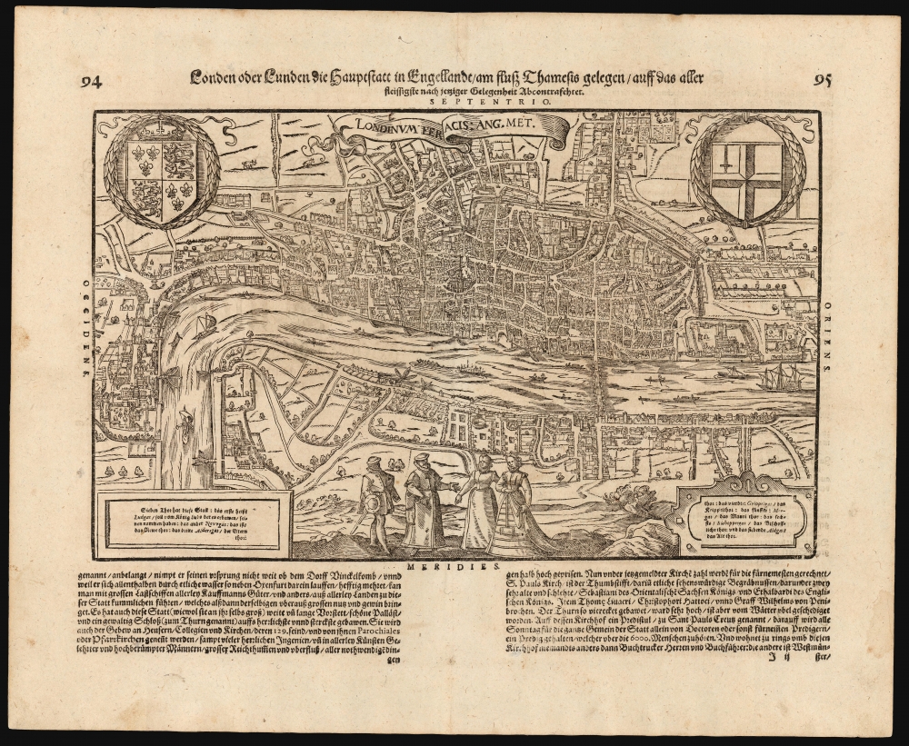
1598 Münster View of London, England
London-munster-1598$1,125.00


Title
Londen oder Lunden die Hauptstatt in Engellandt / am fluß Thamesis gelegen/ auff das aller fleißsigste nach jetziger gelegenheit abcontrafehtet.
1598 (undated) 11.5 x 15 in (29.21 x 38.1 cm)
1598 (undated) 11.5 x 15 in (29.21 x 38.1 cm)
Description
This scarce woodcut is the third earliest acquirable depiction of London. Prepared in 1598, it was the only depiction of London to appear in Münster's Cosmographia, appearing in only the three last Sebastian Petri editions of that work. (While pre-dated by the 1593 Norden and the 1595 Valegio plans in James Howgego's cartobibliography, these are not acquirable in their first editions.)
It might be supposed that the appearance of an updated Cosmographia such as Belleforest's signaled to its publishers that Münster's hoary work, with its 35-year-old maps, might be due for an overhaul. In 1588, Sebastian Petri began publishing the work with new maps and views. Surprisingly, Petri had little to add for Britain: that section in the 1588 edition is substantially the same as the one from 1578. Not until a decade had passed would the new edition include this image - with the result that only the 1598, the 1614, and the 1628 editions of Cosmographia contain it.
A Classic, Decorative Woodcut
Modeled on Georg Braun and Franz Hogenberg's 1572 plan, the city here is laid out as a plan, but the buildings and surrounding landscape are presented in elevation - thus giving the impression of a bird's-eye view, even to the extent of detailing gardens and showing bustling river traffic. Also, as with the Braun and Hogenberg, the anonymous formschneider has included four figures in the foreground: a nobleman and woman, with their attendant maid and footman (he, armed with a sword and buckler), each dressed in the styles of the period appropriate to their positions.A Late Addition
From its first edition, Münster's Cosmographia included a text describing England and the British Isles. The shortness of that section indicated that for many years, Münster didn't know much about islands. In the 15th century, the British Isles were, of European lands, nearly as remote and unknowable as Scandinavia. When, in 1550, Münster was able to get firsthand reports of those islands, they came via Scotsman Alexander Ales, and so Cosmographia included a depiction of Edinburgh well before one of London.The Early London Plans
The first single-sheet plan of London was in Cologne in 1572 by Georg Braun and Franz Hogenberg. The second acquirable London plan was a woodcut executed for Francois de Belleforest's 1575 French translation of Münster. No other acquirable plan of London was issued until this one in 1598.It might be supposed that the appearance of an updated Cosmographia such as Belleforest's signaled to its publishers that Münster's hoary work, with its 35-year-old maps, might be due for an overhaul. In 1588, Sebastian Petri began publishing the work with new maps and views. Surprisingly, Petri had little to add for Britain: that section in the 1588 edition is substantially the same as the one from 1578. Not until a decade had passed would the new edition include this image - with the result that only the 1598, the 1614, and the 1628 editions of Cosmographia contain it.
The Source Plan
In the above iterations, this remained the final depiction of London made before the Great Fire of 1666. (Howgego notes that the Great Fire and the problems attendant to land ownership and rebuilding led to the first proper surveys of the city.) It is an image of a still older London: St. Paul's Cathedral still sports the tall, pointed spire, which was destroyed in 1561. The 1572 plan was based on an earlier work that has not survived in completion: a now-lost 15-sheet plan of the city, the so-called 'copperplate map' of which only three plates now survive. The authorship of the 'copperplate map' is not known. It has been speculated that the Hansa in London played some part in its production, even commissioning the work - resulting in the laudatory paragraph to the Hansa that survives on the Braun and Hogenberg. By the time this plan was made, the Hansa had lost their grip on London's trade, and indeed, Elizabeth I ordered the Hansa out of London completely by 1597.Publication History and Census
This woodcut was executed by an anonymous artist for inclusion in the 1598 Sebastian Petri edition of Münster's Cosmographia. Consequently, it appeared in only three editions of the work, making it among the rarest of the woodcuts from Münster's book and one of the rarest plans of London. The present example conforms typographically to the 1614 German-text edition of the book. Only one example of the separate plan is recorded in OCLC, in the collection of the Hergozin Anna Amalia Bibliothek Klassic.CartographerS
Sebastian Münster (January 20, 1488 - May 26, 1552), was a German cartographer, cosmographer, Hebrew scholar and humanist. He was born at Ingelheim near Mainz, the son of Andreas Munster. He completed his studies at the Eberhard-Karls-Universität Tübingen in 1518, after which he was appointed to the University of Basel in 1527. As Professor of Hebrew, he edited the Hebrew Bible, accompanied by a Latin translation. In 1540 he published a Latin edition of Ptolemy's Geographia, which presented the ancient cartographer's 2nd century geographical data supplemented systematically with maps of the modern world. This was followed by what can be considered his principal work, the Cosmographia. First issued in 1544, this was the earliest German description of the modern world. It would become the go-to book for any literate layperson who wished to know about anywhere that was further than a day's journey from home. In preparation for his work on Cosmographia, Münster reached out to humanists around Europe and especially within the Holy Roman Empire, enlisting colleagues to provide him with up-to-date maps and views of their countries and cities, with the result that the book contains a disproportionate number of maps providing the first modern depictions of the areas they depict. Münster, as a religious man, was not producing a travel guide. Just as his work in ancient languages was intended to provide his students with as direct a connection as possible to scriptural revelation, his object in producing Cosmographia was to provide the reader with a description of all of creation: a further means of gaining revelation. The book, unsurprisingly, proved popular and was reissued in numerous editions and languages including Latin, French, Italian, and Czech. The last German edition was published in 1628, long after Münster's death of the plague in 1552. Cosmographia was one of the most successful and popular books of the 16th century, passing through 24 editions between 1544 and 1628. This success was due in part to its fascinating woodcuts (some by Hans Holbein the Younger, Urs Graf, Hans Rudolph Manuel Deutsch, and David Kandel). Münster's work was highly influential in reviving classical geography in 16th century Europe, and providing the intellectual foundations for the production of later compilations of cartographic work, such as Ortelius' Theatrum Orbis Terrarum Münster's output includes a small format 1536 map of Europe; the 1532 Grynaeus map of the world is also attributed to him. His non-geographical output includes Dictionarium trilingue in Latin, Greek, and Hebrew, and his 1537 Hebrew Gospel of Matthew. Most of Munster's work was published by his stepson, Heinrich Petri (Henricus Petrus), and his son Sebastian Henric Petri. More by this mapmaker...
Heinrich Petri (1508 - 1579) and his son Sebastian Henric Petri (1545 – 1627) were printers based in Basel, Switzerland. Heinrich was the son of the printer Adam Petri and Anna Selber. After Adam died in 1527, Anna married the humanist and geographer Sebastian Münster - one of Adam's collaborators. Sebastian contracted his stepson, Henricus Petri (Petrus), to print editions of his wildly popular Cosmographia. Later Petri, brought his son, Sebastian Henric Petri, into the family business. Their firm was known as the Officina Henricpetrina. In addition to the Cosmographia, they also published a number of other seminal works including the 1566 second edition of Nicolaus Copernicus's De Revolutionibus Orbium Coelestium and Georg Joachim Rheticus's Narratio. Learn More...
Source
Münster, S., Cosmographei oder beschreibung aller länder, (Basel: Petri) 1598.
The Cosmographia Universalis, one of the greatest geographical and historical works of the 16th century, 'taught nearly three generations of laymen most of what they knew about the world beyond their native places' (Strauss). Filled with maps, views, and rich descriptions of places throughout Europe and beyond, it was the best general source of geographical information until the advent of Ortelius' Theatrum. It was first issued by Sebastian Munster (1488 - 1552) in its 1544 German edition, and stayed in print long after its author's death in thirty five editions, and in five languages. (Of these, the 1550 and 1552 editions are widely regarded as the most complete and truest to the author's intentions: thereafter, later editors continued to add to the work's text; editions from 1588 onwards employed an entirely different set of maps produced on Ortelius' model.) Munster's goal, initially, was to rally his homeland's humanists and scholars to produce a new map of Germany in order to 'see what kind of a land our ancestors conquered for their home... bring honor to our country and place its beauties in the clear light of day.' Munster's project quickly expanded to cover the known world in its scope to produce a 'sufficiently large volume, in which I touch upon the foundation of all nations and kingdoms, their peculiarities, rivers, mountains, customs of men, royal successions, origins of the more important cities, succinct histories, religions, characteristics and fertility of lands... in Germany, however, I tarry a little longer'.
Munster's methodology in Cosmographia is notable in particular for his dedication to providing his readers with direct access to firsthand reports of his subjects wherever possible. Many of the maps were the result of his own surveys; others, the fruit of an indefatigable letter writing campaign to scholars, churchmen and princes throughout Europe, amicably badgering them for maps, views, and detailed descriptions of their lands. For lands further afield than his letters could reach, Munster relied on the best that the authorities of northern European scholarship could offer: he was well familiar with the work of Waldseemuller and other geographers of the early 16th century, and was well connected with the best geographers of his own generation. A disproportionate number of the maps of Cosmographia show contemporary geographical knowledge of the their respective areas for the very first time: The first map to show the continents of the Western Hemisphere; the first map to focus on the continent of Asia; the first modern map to name the Pacific Ocean; the first map to use a key; the first modern map of the British Isles and so on. Even in cases where earlier maps exist, Munster's works very often remain the earliest such acquirable by the collector.
Munster's methodology in Cosmographia is notable in particular for his dedication to providing his readers with direct access to firsthand reports of his subjects wherever possible. Many of the maps were the result of his own surveys; others, the fruit of an indefatigable letter writing campaign to scholars, churchmen and princes throughout Europe, amicably badgering them for maps, views, and detailed descriptions of their lands. For lands further afield than his letters could reach, Munster relied on the best that the authorities of northern European scholarship could offer: he was well familiar with the work of Waldseemuller and other geographers of the early 16th century, and was well connected with the best geographers of his own generation. A disproportionate number of the maps of Cosmographia show contemporary geographical knowledge of the their respective areas for the very first time: The first map to show the continents of the Western Hemisphere; the first map to focus on the continent of Asia; the first modern map to name the Pacific Ocean; the first map to use a key; the first modern map of the British Isles and so on. Even in cases where earlier maps exist, Munster's works very often remain the earliest such acquirable by the collector.
Condition
Excellent Faint marginal soiling, few spots outside image.
References
OCLC 552017967. Howgego, J., Printed Maps of London circa 1553-1850. No. 6 (1614 edition not recorded).