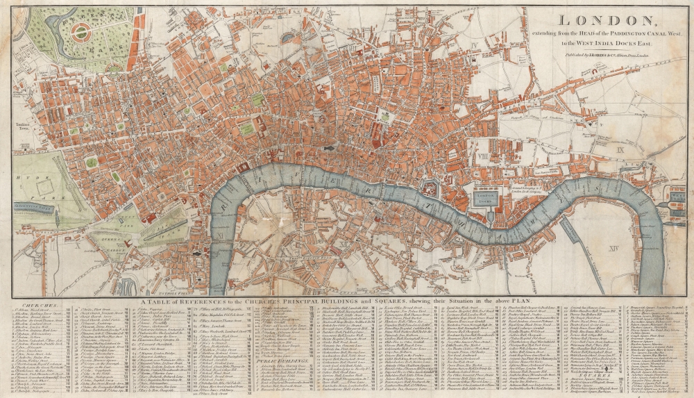
1816 Robins / Russell Plan of London
London-robins-1816
Title
1816 (undated) 13 x 22 in (33.02 x 55.88 cm) 1 : 18000
Description
A Closer Look
As indicated in the title, the map covers from the Paddington Canal (near Hyde Park) to the West India Docks near a crook in the Thames at the Isle of Dogs. The map is divided into evenly-sized blocks labeled with Roman numerals, allowing for easy location of more than 150 sites listed in an index below. These include an extensive list of churches, government offices, theaters, inns, schools, jails (goals), prisons, and squares. Additional sites, including royal palaces, cemeteries (including more than one 'Jews burying ground'), bridges, parks, gardens, hospitals, workhouses, and more, are noted on the map itself. Major landmarks such as St. Paul's Cathedral, the Tower of London, and the Houses of Parliament are prominently displayed.Historical Context
This map captures late Georgian London in a time of transition, as the infrastructure (bridges, canals, docks, roads) was being built, which would allow London to absorb a massive influx of immigrants in the following decades. For example, the 'ghosting in' of Swallow Street between Oxford St. and Piccadilly refers to the demolition of Swallow Street in 1815 to create the thoroughfare of Regent Street. The Commercial Road at right was built at the start of the 19th century to establish a better connection between the East and West India Docks and the city center. Likewise, the London Docks just to the east of the Tower of London had only been completed in 1815, as had the Waterloo Bridge.Publication History and Census
This map was prepared and published by James Robins. The inclusion of 'Albion Press' after Robins' name is more likely a reference to the type of iron printing press invented in the early 19th century rather than an associated publishing firm. The map is undated but is believed to be c. 1816 from the naming of the 'Waterloo or Strand Bridge' (originally known as the Strand Bridge but renamed in 1816 to commemorate the British victory at the Battle of Waterloo) and other details. The naming of Southwark Bridge as such might indicate a slightly later date, c. 1820. This map is only listed among the holdings of the British Library in the OCLC. The London Archives also holds an example. The map only occasionally comes to market. It is a later edition of a c. 1806 map which contains the subtitle 'with the proposed Improvements between the Royal Exchange and Finsbury Square,' attributed to John Russell and published by James Stratford rather than Robins. The 1806 edition appeared in David Hughson's book, London, being an accurate history and description of the British Metropolis and its neighborhoods… but may have also been separately issued.CartographerS
James Robins (fl. c. 1816 - 1835) was a publisher of books, prints, and maps based in London in the early 19th century. Details about the company and its founder are scant. The firm may have had a branch in Dublin, operated by Robins' son. Its publications included an atlas of England and Wales, a multi-volume history of England in the reign of George III, and a collection of portraits of 'distinguished characters' of the sort who would appear in freak shows. More by this mapmaker...
John Russell (c. 1750 - 1829) was a British cartographer active in London during the late 18th and early 19th centuries. Russell apprenticed as a goldsmith under William Palmer before turning to engraving and printing. He drew maps and engraved for several major publishers of his period including Alexander Dalrymple, Benjamin Henry, Robert Sayer, John Moore, and William Guthrie. Russell's 10 apprentices included such prominent cartographers as Alexander Findlay and Samuel Clapp. Russell was based on Constitution Row Grays Inn Lane, Middlesex (London). Learn More...

