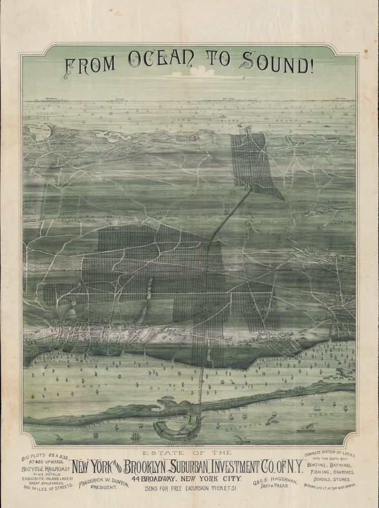
A stunning 1892 Oakley H. Bailey chromolithograph bird's-eye view of a portion of Suffolk County, Long Island. Bailey issued the view for the New York and Brooklyn Suburban Investment Company. The view is a striking artifact charting urbanization. It is also associated with the rash of land speculation scams that plagued Long Island in the late 19th century.
A Closer Look
Looking north, the view takes in a wide section of Long Island, including Fire Island and the Great South Bay in the foreground, the towns and communities of Patchogue, Bellport, Brookhaven, Medford, Coram, Selden, Middle Island, Rocky Point, Mt. Sinai, and Port Jefferson. In the background are the Long Island Sound and coastal cities of Connecticut. The lines of the Long Island Railroad (LIRR), the backbone of transportation in the area (along with ferries), run east-west across the view.
A grid demonstrating available plots overlays illustrations of existing coastal towns on either side of the island. Development along these lines seemed like a safe bet, given the exploding population of Manhattan and Brooklyn, the abundance of inexpensive land, and attractive qualities noted here, such as beaches and sailing. However, the effort was premature, and the vision laid out here was not realized, or at least not immediately.
The New York and Brooklyn Suburban Investment Co.
The New York and Brooklyn Suburban Investment ran one of the largest land speculation scams in Long Island. The scam is one of several that plagued Long Island in the late 19th century, targeting mostly working middle-class Brooklynites. An expose in the March 7, 1897
Brooklyn Eagle exposes the scam:
The largest operators in Suffolk County have been the New York and Brooklyn Investment Company of New York, incorporated April 3, 1890, with a capital stock of $100,000. The incorporators were Herbert H. Walker, George Hegeman, and George A. Weaver. It did business in 1889 as a New Jersey corporation. Over 15,000 deeds have been placed on record by this company. H.H. Walker, the company’s first president, was succeeded by Frederick W. Dunton of Jamaica. George E. Hegeman is now president and O.L. Schwenke, secretary. The company obtained control of 11,258 acres of land, extending from the Montauk division of the Long Island Railroad on the south to Long Island Sound on the north. It includes land at East Patchogue, Patchogue, Bellport, Woodville, West Yaphank, Waverly, Farmingdale, and Rocky Point. The lands are assessed at an average of $2 per acre. Over 15,000 lots have been sold at from $10 to $15 apiece, corner lots bringing from $30 to $40. The company has laid out some money in building roads through the tract and has marked out the lots sold by stakes. Orange T. Fanning, when clerk of Suffolk County, recorded over eight thousand deeds for the company in 1892, which conveyed several times that number of lots. Hegeman obtained a judgment against the company in 1892, and 1,300 of the lots were sold by the sheriff and bought in by the plaintiff. The operations of the company have been ventilated in the courts in the actions brought by Hegeman against Dunton.
The Long Island Boynton Bicycle Railroad
Also present here is the north-south never-built Long Island Boynton Bicycle Railroad. Eben Moody Boynton had conceived of bicycle railroads, so named because the trains sat on two wheels running along a single rail on the ground (effectively a monorail) and were stabilized by small wheels on either side of an overhead rail, as a less expensive method of passenger transportation. His model allowed relatively small trains traveling in opposite directions to pass each other using around the same space as a single track of a standard gauge railway. Boynton was able to implement the concept in the 1890s on two short-lived lines running to Brighton Beach and Coney Island, and hoped to use double-decker passenger trains on the line displayed here between Rocky Point and Fire Island.
Having received the backing of Frederick Dunton and George Hagerman, Boynton built a test track between East Patchogue and Bellport in 1894, which was written up in the
Scientific American in February of that year. The test track operated a passenger service between the two towns for a short time. But the project ran afoul of the LIRR, whose president was incidentally Dunton's father-in-law, as it would have to intersect with LIRR tracks using either subways or elevated portions, and because the success of Boynton's train might open competition to LIRR's virtual monopoly over transportation in the area. With LIRR outright opposed to the project, Boynton was never able to secure funding and the test track was dismantled in 1902.
Chromolithography
Chromolithography, sometimes called oleography, is a color lithographic technique developed in the mid-19th century. The process involved using multiple lithographic stones, one for each color, to yield a rich composite effect. Oftentimes, the process would start with a black basecoat upon which subsequent colors were layered. Some chromolithographs used 30 or more separate lithographic stones to achieve the desired product. Chromolithograph color could also be effectively blended for even more dramatic results. The process became extremely popular in the late 19th and early 20th centuries when it emerged as the dominant method of color printing. The vivid color chromolithography produced made it exceptionally effective for advertising and propaganda imagery.
Publication History and Census
This view was published by by O.H. Bailey for the New York and Brooklyn Suburban Investment Company. It is undated, but likely was published between 1892 and 1894. Only one example is known to exist in institutional collections, at the Brooklyn Public Library, and it is scarce to the market.
Cartographer
Oakley Hoopes Bailey (June 14, 1843 - August 13, 1947) was a prolific American viewmaker, artist, and lithographer active in late 19th and early 20th century. Bailey was born in Beloit, Mahoning County, Ohio. He matriculated in 1861 at Mount Union College in Alliance, Ohio, where he studied architecture. At the outbreak of the American Civil War (1861 - 1865) he briefly abandoned his studies for 2 years, wherein he saw combat as a Union solider. After the war, in 1866, he returned to Mount Union to complete his degree. Bailey was the younger brother of another view artist, Howard Heston Bailey (1836 - 1878) and followed his brother into the print business, producing his first city views, of Milwaukee, Wisconsin, in 1871. Active from 1871 to 1926, Bailey is known for more than 375 recorded city views, covering more than 13 states 2 Canadian provinces, making him one of the most active viewmakers in American history. In 1875, he settled in Cambridge, Massachusetts and most of his subsequent work focused on Massachusetts and Connecticut. Bailey worked with many other American viewmakers of the period, including his brother, Howard Heston Bailey, Thaddeus M. Flower, and J. C. Hazen, among others. Even his wife, Sarah F. Bailey (1846 - 19??) got into the business, drawing at least one view, of Watkins Glen, New York. Around 1904, by this time in his 60s, Bailey entered into a publishing partnership with Thomas S. Hughes, publishing their 'aero-views' as 'Hughes and Bailey'. Together, Hughes and Bailey revisited the sites of many of Bailey's early views, remaking them sometimes 20 - 40 years later, the idea being to set them beside the earlier views to show how much the respective towns had changed. The partnership lasted until about 1926. Bailey died in his hometown of Alliance at the ripe old age of 103. More by this mapmaker...
Very good. Light foxing.
OCLC 123529082. 'Wild Long Island Land Schemes: A Rich Field for Unscrupulous Speculators,' Brooklyn Eagle, March 7, 1897.