1891 Hyatt Plat Map of Astoria, Queens, New York City (Ditmars and Steinway)
LongIslandCity-kouwenhoven-1891
Title
1891 (dated) 22.5 x 58.5 in (57.15 x 148.59 cm) 1 : 915
Description
A Closer Look
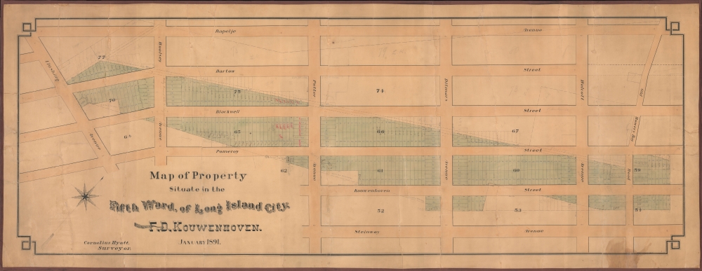
Oriented towards the northwest, this map covers a portion of Astoria, Queens, between Rapelje Avenue (now 33rd Street) and Steinway Avenue (now Steinway Street) and from Flushing Avenue (also known as the 'Astoria and Flushing Turnpike,' now Astoria Boulevard) to Old Bowery Bay Road (now 20th Road, still bow-shaped unlike the surrounding city grid). Most street names have changed (except for Steinway and Ditmars), but the orientation is recognizable. Lots are drawn in a diagonal strip across the street grid (with most blocks numbered), and many are marked as sold, including several as 'sold to Steinway.' Other interesting notes appear, such as 'Woolsey Avenue is sold to Long Island City.'Before Astoria
The title claims this area to be part of Long Island City, but it is quite far from the modern-day neighborhood known by that name. This part of today's Astoria was known by several names, including Steinway Village and 'East Astoria'; the former was named for Henry E. Steinweg (Steinway), who operated several businesses there, including the famous piano company Steinway and Sons (founded 1853). Steinway Village was an early example of a factory town, with self-contained housing, transportation, and services, and was seen as offering workers good living conditions. The growth of Steinway's piano business caused the area's population to increase rapidly. In 1870, Steinway Village and several nearby settlements were incorporated into Long Island City, which in 1898 was incorporated into New York City along with the rest of Queens (except for the Town of Hempstead, which became Nassau County).Steinway and His Enterprises
Heinrich Engelhard Steinweg (1797 - 1871), better known by his English name Henry E. Steinway, was a German-born entrepreneur who played a pivotal role in the history of Queens, New York. Growing up during the tumultuous Napoleonic Wars, he was mistakenly believed to have lost his father and brothers in warfare as a young child before they surprisingly returned years later. Near the end of the conflict, in 1814, Steinway volunteered to fight Napoleon's armies as part of the Schwarze Schar. After ending his military service, Steinway began building and repairing instruments, which became his profession. In Europe, he was constrained by the guild system and, like many German immigrants to the United States, emigrated in the wake of the failed Revolutions of 1848. He settled in New York City with his five sons (his eldest son, Christian Friedrich Theodor Steinweg, remained in Europe and operated his own piano manufacturing company, with the U.S. and German branches of the family business cooperating and influencing each other for several decades). Over time, Steinway and Sons pianos have become renowned for their quality, and the company still operates a large factory (built in 1873) on the banks of Bowery Bay in Astoria.F. D. Kouwenhoven
Francis Duryea Kouwenhoven (1826 - 1912) was a lifelong resident of the area around Bowery Bay in today's Astoria, a descendant of the prominent Van Kouwenhoven family (sometimes spelled Cowenhoven) of early Dutch settlers to New Amsterdam. Not long after arriving in Manhattan, the Van Kouwenhovens relocated to Rennsselaerville (near Albany) and then in 1636 to the Flatlands on Long Island, acquiring the first deed of land on the island and very possibly constituting the first white settlers. A branch of the family then married into the Luyster family, which owned land (some 120 acres) around Bowery Bay, which is how F. D. Kouwenhoven inherited them. He appears to have led a relatively uneventful life enjoying his inheritance but was convinced to gradually sell off much of the family estate to developers (including Steinway). Nevertheless, even late in life, F. D. Kouwenhoven owned a significant portion of the land in the area (even more than Steinway, at least by number of lots) according to contemporary volumes of The City Record, which provided assessed valuation of city real estate.Publication History and Census
This map was drawn by surveyor Cornelius Hyatt in January 1891, perhaps for Kouwenhoven himself to present to potential buyers or to track sales. We are unaware of any other examples of this map in institutional collections or on the market.Cartographer
Cornelius Hyatt (October 10, 1831 - January 2, 1904) was a surveyor active on Long Island around the village of Newtown (Elmhurst), who produced several early plat maps of what would become Astoria, Elmhurst, Woodside, and other nearby neighborhoods as they were developing rapidly at the end of the 19th century. Few details of his life are known, but he appears to have been a longtime resident of the area, present since at least 1850, and was a farmer before - or in addition to - becoming a surveyor and civil engineer. Hyatt appears to have been a considerable landholder himself, including a homestead in the village of Winfield, now Woodside. More by this mapmaker...


