This item has been sold, but you can get on the Waitlist to be notified if another example becomes available.
1942 Jo Mora Pictorial Map ('Carte') of Los Angeles, California
LosAngeles-mora-1942$3,250.00

Title
Historical and Recreational Map of Los Angeles.
1942 (dated) 30.5 x 23 in (77.47 x 58.42 cm)
1942 (dated) 30.5 x 23 in (77.47 x 58.42 cm)
Description
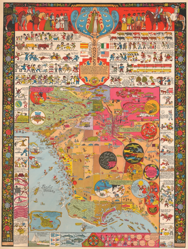
This is a 1942 Jo Mora pictorial map of Los Angeles, California. This is Mora's rarest and most sought-after pictorial map and arguably the best pictorial map of Los Angeles ever issued. It is filled with Mora's unique humor and artistry, which captures Los Angeles' culture, folklore, and history.
An elaborate pictorial border fills the remainder of the sheet. The border recounts Los Angeles' history from its founding in 1781 through 1942. Depicted events include the gold rush, the Pony Express, battles during the Mexican-American War, the arrival of the transcontinental railroads, and the constant struggle to bring water to the city. Along the bottom border, Mora tracks LA's population and the evolution of women's fashion.
A Closer Look
A pictorial map of Los Angeles occupies over half of the sheet, with coverage embracing from Burbank to the Pacific Ocean and from Malibu to Santa Fe Springs. Vignettes mark sites throughout the city, including the La Brea Tar Pits, the zoo and Greek Theatre in Griffith Park, U.S.C., U.C.L.A., and Lincoln Park. Numerous movie studios are labeled, including Disney (complete with Mickey Mouse), 20th Century Fox (marked by a fox in a suit), Paramount, Colombia, and RKO. People flock to Los Angeles's beaches and are illustrated swimming and otherwise frolicking.An elaborate pictorial border fills the remainder of the sheet. The border recounts Los Angeles' history from its founding in 1781 through 1942. Depicted events include the gold rush, the Pony Express, battles during the Mexican-American War, the arrival of the transcontinental railroads, and the constant struggle to bring water to the city. Along the bottom border, Mora tracks LA's population and the evolution of women's fashion.
20th Century Pictorial Cartography
Pictorial qualities have been common in cartography from at least the 16th century when publishers like Braun and Hogenberg incorporated view-like qualities and other pictorial elements into their famous city plans. Braun and Hogenberg, and similar cartographers, issued their town books to express not necessarily the geography of their subjects but rather the 'essence' of the town/city. As mathematics and surveying principles advanced, travel increased, and the ability to translate two-dimensional cartographic perspectives into an understanding of the actual world became commonplace, maps themselves transformed. This trend is a recognizable progression that evolved cartographic conventions from the 17th to the 19th centuries. By the late 19th century, most maps had become geographical tools that illustrated the region cartographically but failed in the original raison d'être, as expressed by Braun and Hogenberg, to illustrate a place's 'essence.' So, where a city map of 19th-century Paris might provide a completely navigable presentation of the city, one could glean almost nothing of Paris' character from it. In the late 18th century, the first modern 'pictorial' style maps developed. These maps, like Tomas Lopez's 1788 map of Seville, attempted to provide both cartographic accuracy and pictorial elements that might convey the city's character. In that case, Lopez incorporated pictorial vignettes to illustrate important buildings and monuments. This style became increasingly common throughout the 19th and early 20th centuries, particularly for centers of commerce like London, Paris, and Rome, where they were often mass-produced and referred to as 'monumental' maps. The style further evolved in the early to mid-20th century, when revolutionary cartographers and illustrators like MacDonald Gill, Jo Mora, Frank Dorn, Ernest Dudley Chase, and many others combined vignette style illustrations, modern printing techniques, and inspiration from Japanese printmaking and manga and clever satirical cartographers/artists like Fred Rose, to produce maps that once again focused on revealing the essence a place, usually, but not always, at the sacrifice of cartographic precision.Publication History and Census
This map was created and published by Jo Mora in 1942. Two primary editions were published: one without a title and one with a title (as here). An additional printing of the titleless variant was later printed on butcher paper in a limited edition of 50-100 copies. We note a single cataloged example in OCLC, which is part of the collection at the Library of Congress, but as that example has not been digitized, we do not know which edition it represents. The David Rumsey Map Collection has an example of all 3 variants.Cartographer
Joseph 'Jo' Jancito Mora (October 22, 1876 – October 10, 1947) was an Uruguayan born artist active in California during the first half of the 20th century. Mora immigrated to California as a young man. He studied art in Boston and, after graduating, worked there briefly before relocating to California. In cartographic circles Mora is known for pioneering the 20th century pictorial map. In a series he referred to as his 'cartes,' published between in 1926 and 1942, Mora developed a pictorial style that combined cartography with colorful cartoonish image of local figures, folklore, history, and natural wonders. His earliest maps were commissioned by the Hotel Del Monte and included California's Playground and The Seventeen Mile Drive. As he matured as a cartographer, his work became increasingly dense, often packed with tiny figures, each expressive of some aspect of regional life. Mora, often called the 'Renaissance man of the West' also worked as an illustrator, muralist, sculptor, photographer, and writer. His masterpiece is considered to be the Father Serra Cenotaph, a bronze and marble sculpture at the Memorial Chapel in El Carmelo Mission, Carmel, California. His map work included Monterey Penninsula (1927), and Seventeen Mile Drive (1927), California (1927), Grand Canyon (1931), Yosemite (1931), Yellowstone (1936), Carmel-By-The-Sea (1942), California (1945) (large and small versions), Map of Los Angeles (1942), among others. More by this mapmaker...
Condition
Very good. Mounted on linen.
References
Rumsey 8540.000. OCLC 80872336.