This copy is copyright protected.
Copyright © 2025 Geographicus Rare Antique Maps
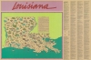
1987 Louisiana Dept. of Tourism Pictorial Map of Louisiana in French for French Tourists
LouisianaBonTemps-depttourism-1987


Copyright © 2025 Geographicus Rare Antique Maps | Geographicus Rare Antique Maps
This copy is copyright protected.
Copyright © 2025 Geographicus Rare Antique Maps