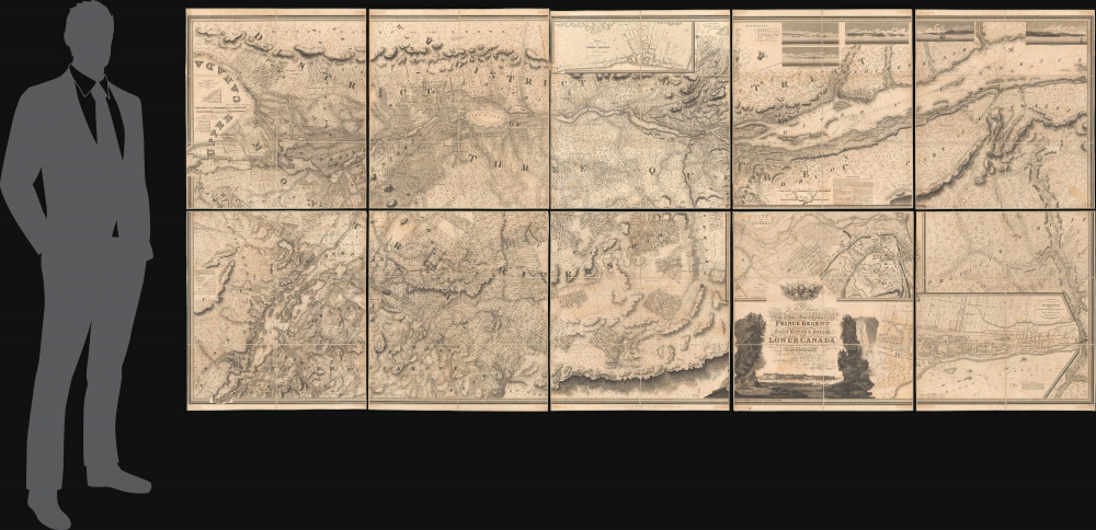
Digital Image: 1815 Bouchette Masterplan of Lower Canada (Ontario) and Lake Champlain
LowerCanada-bouchette-1815_d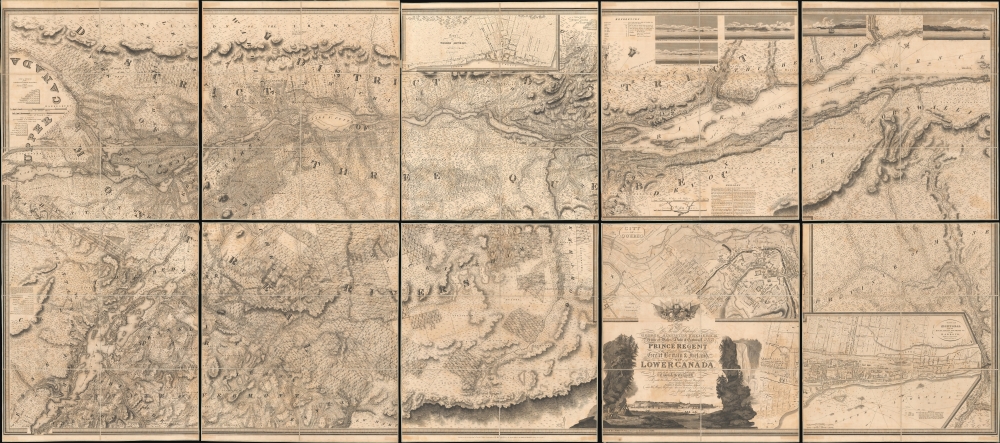


Description
FOR THE ORIGINAL ANTIQUE MAP, WITH HISTORICAL ANALYSIS, CLICK HERE.
Digital Map Information
Geographicus maintains an archive of high-resolution rare map scans. We scan our maps at 300 DPI or higher, with newer images being 600 DPI, (either TIFF or JPEG, depending on when the scan was done) which is most cases in suitable for enlargement and printing.
Delivery
Once you purchase our digital scan service, you will receive a download link via email - usually within seconds. Digital orders are delivered as ZIP files, an industry standard file compression protocol that any computer should be able to unpack. Some of our files are very large, and can take some time to download. Most files are saved into your computer's 'Downloads' folder. All delivery is electronic. No physical product is shipped.
Credit and Scope of Use
You can use your digial image any way you want! Our digital images are unrestricted by copyright and can be used, modified, and published freely. The textual description that accompanies the original antique map is not included in the sale of digital images and remains protected by copyright. That said, we put significant care and effort into scanning and editing these maps, and we’d appreciate a credit when possible. Should you wish to credit us, please use the following credit line:
Courtesy of Geographicus Rare Antique Maps (http://www.geographicus.com).
How Large Can I Print?
In general, at 300 DPI, you should at least be able to double the size of the actual image, more so with our 600 DPI images. So, if the original was 10 x 12 inches, you can print at 20 x 24 inches, without quality loss. If your display requirements can accommodate some loss in image quality, you can make it even larger. That being said, no quality of scan will allow you to blow up at 10 x 12 inch map to wall size without significant quality loss. For more information, it is best consult a printer or reprographics specialist.
Refunds
If the high resolution image you ordered is unavailable, we will fully refund your purchase. Otherwise, digital images scans are a service, not a tangible product, and cannot be returned or refunded once the download link is used.
Cartographer S
Joseph Bouchette (May 14, 1774 - April 8, 1841) was a British Canadian military officer and cartographer. Bouchette was born in Quebec City, the son of Jean-Baptiste Bouchette, a military topographer and naval officer, and Marie Angelique Duhamel, daughter of Julien Duhamel (1723 - 1778). During the American Revolutionary War (1775 - 1783), Joseph's father famously saved the life of General Guy Carleton (1724 - 1808), Commander-in-Chief of the British Forces in North America, navigating him and his family along the Saint Lawrence River from Montreal, through the American lines, to Quebec. This accomplishment has significant ramifications for both the war, reversing the outcome of the 1775 Battle of Quebec, and the Bouchette family, earning Bouchette a grant of 6,000 acres and a significant military promotion. Joseph, now practically a nobleman, followed his father as a topographer and naval officer. He initially studied art and architecture under François Baillairgé (1759 - 1830), but in 1790, after a short and distinguished naval career, Bouchette entered the service of his (now elderly) uncle Samuel Holland (1728 - 1801), the first Surveyor-General of British North America. He moved to Quebec to work at the Surveyor General's offices and found the offices in disarray. Bouchette took on the task of reorganizing the offices, earning him the official position of Surveyor-General after Holland's death. With Charles Burton Wyatt, Bouchette resurveyed Lower Canada from 1805 to 1807. This work was compiled and published in 1815 as the Topographical Description of the Province of Lower Canada, which was the sum of all contemporaneous knowledge of the territory. He held the position of Surveyor General until 1826 when he retired, and the position was taken up by his son, Joseph-Francis Bouchette (1800 - 1881). After he died in 1841, he was entombed in Montreal's Notre Dame des Neiges Cemetery. More by this mapmaker...
William Faden (July 11, 1749 - March 21, 1836) was a Scottish cartographer and map publisher of the late 18th century. Faden was born in London. His father, William MacFaden, was a well-known London printer and publisher of The Literary Magazine. During the Jacobite Rebellion (1745 - 1746), MacFaden changed his family name to Faden, to avoid anti-Scottish sentiment. Faden apprenticed under the engraver James Wigley (1700 - 1782), attaining his freedom in 1771 - in the same year that Thomas Jefferys Sr. died. While Thomas Jefferys Sr. was an important and masterful mapmaker, he was a terrible businessman, and his son, Jefferys Jr., had little interest in building on his father's legacy. MacFaden, perhaps recognizing an opportunity, purchased his son a partnership in the Jefferys firm, which subsequently traded as 'Faden and Jefferys'. Jefferys Jr. also inherited Jefferys Sr.'s title, 'Geographer to the King and to the Prince of Wales'. With little interest in cartography or map publishing, Jefferys Jr. increasingly took a back seat to Faden, and by 1776, he had withdrawn from day-to-day management, although he retained his financial stake. The American Revolutionary War (1775 - 1783) proved to be a boom for the young 'Geographer to the King', who leveraged existing materials and unpublished manuscript maps to which he had access via his official appointment to publish a wealth of important maps, both for official use and the curious public - this period of prosperity laid the financial underpinning for Faden, who by 1783, at the end of the war, acquired full ownership of the firm and removed the Jefferys imprint. In 1801, he engraved and published the first maps for the British Ordnance Survey. By 1822, Faden published over 350 maps, atlases, and military plans. He retired in 1823, selling his plates to James Wyld Sr. Faden died in 1836. Learn More...
John Walker (1787 - April 19, 1873) was a British map seller, engraver, lithographer, hydrographer, geographer, draughtsman, and publisher active in London during the 19th century. Walker published both nautical charts and geographical maps. His nautical work is particularly distinguished as he was an official hydrographer for the British East India Company, a position, incidentally, also held by his father of the same name. Walker's maps, mostly published after 1827, were primarily produced with his brothers Charles Walker and Alexander Walker under the imprint J. and C. Walker. Among their joint projects are more than 200 maps for the influential Society for the Diffusion of Useful Knowledge Atlas (SDUK). In addition they published numerous charts for James Horsburgh and the British Admiralty Hydrographic Office, including Belcher's important map of Hong Kong and Carless' exploratory map of Karachi. The J. and C. Walker firm continued to publish after both Walkers died in the 1870s. Learn More...