This item has been sold, but you can get on the Waitlist to be notified if another example becomes available, or purchase a digital scan.
1753 Van Keulen 'Secret Atlas' Map of East Africa, Madagascar, and Mauritius
Madagascar-vankeulen-1753$3,750.00


Title
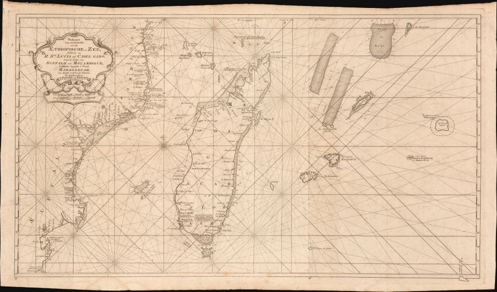
Paskaart van een Gedeelte van de Aethiopische-Zee, Strekkende van R. Sta. Lucia tot C. del Gado, Langs de Kusten van Suffalo en Mocambique, Bevattende Insgelyks 't Eiland Madagascar met Desselfs Onderhorige Eilanden.
1753 (undated) 19.75 x 35 in (50.165 x 88.9 cm) 1 : 4200000
1753 (undated) 19.75 x 35 in (50.165 x 88.9 cm) 1 : 4200000
Description
This is an extremely rare 1753 Johannes II van Keulen / Jan de Marre nautical map of Madagascar, Mauritius, and the adjacent coast of Africa compiled for the sixth volume of the Zee-Fakkel - the Dutch East India Company's legendary 'Secret Atlas.' The map reveals tightly controlled navigational secrets when Madagascar was a haven not only for the world's most notorious pirates (including Captain Kidd) but also a source for the Atlantic Slave Trade.
A text box in southern Madagascar notes that the placenames derive not only from Portuguese but also English. Throughout the second half of the 17th century, Madagascar was not a through-point but was itself a major destination in the transatlantic slave trade. Madagascar's Malagasy people had been taken by Arab and Swahili slavers going back to the 16th century. The English would come to dominate this trade in the latter part of the 17th century, enslaving people at Madagascar and stopping at the Cape of Good Hope before crossing the Atlantic for Barbados. This is reflected by a note near the northwest shore of Madagascar, indicating that the coast there had been charted in 1682 by the ship Firebrass. That ship, commanded by a Captain Golam, would be encountered by the English ship Charles at Sardinia Bay in January 1683 en route to Barbados with a cargo of enslaved Malagasy from Madagascar. This journey was among the longest and deadliest of those in the transatlantic slave trade. Of the nearly 30,000 people taken from Madagascar, fewer than 75% would survive the journey, which took about twice as long as ships leaving from West or Central Africa.
This was likely an attempt to consolidate and improve the general hydrography. Previously, VOC charts in manuscript were disseminated to ship captains on an as-needed basis, to be returned upon a voyage's completion. A study of several VOC manuscript charts issued between 1720 and 1760 reveals striking disparities, likely resulting either from the charts being updated or copied from earlier less accurate charts. These differences led to avoidable navigational errors and the accompanying trade risks. A printed nautical atlas, whose hydrography was built upon the most up-to-date charts reassessed by the greatest chartmaker of the age, was a natural solution.
The 'Secret Atlas' atlas was designed from VOC manuscript material collated and reassessed by Jan de Marre and van Keulen. Ostensibly, it was an extension (Volume VI) of the existing commercially issued Nieuwe Lichtende Zee-Fakkel. However, it was intended only for VOC use and thus became known as the 'Secret Atlas.' The printing run was extremely small, and access was tightly controlled. VOC ship captains navigating to the Far East were given a copy on departure and expected to return it in good condition. Even so, the maps of the 'Secret Atlas' were disseminated, perhaps by the van Keulens themselves. We note evidence of 'secret' Dutch hydrography in charts of the English Pilot and in compeating Dutch charts. Nonetheless, original maps from the 'Secret' Zee-Fakkel Volume VI remain of the utmost rarity.
A Closer Look
The chart covers the coast of Mozambique, from Rio St. Lucia in the south (KwaZulu-Natal) to Cabo Delgado (the northern border of Mozambique). It thus embraces all of Madagascar as well as the Comoros Islands and Mayotte. The chart reaches eastward into the Indian Ocean, including Reunion Island (Isla de Mascarenha), Mauritius, Rodriguez, the shoals of Cargados Carajos, and the phantom islands of Roquepiz and St. Brandao. It is abundantly detailed, with depth soundings, anchorages, notes, and placenames. It identifies Portuguese trade forts at Sofala and Mozambique Island.Explorers and Slavers
Nearly as long as Europeans had been sailing around Africa, they interacted with Madagascar. The passage between the island and the mainland formed an unavoidable bottleneck for most ships sailing between Europe and the Far East. From the earliest maritime journeys around Africa, Madagascar's havens and natural advantages would be taken advantage of by ships en route to the Indies. The locations noted on Madagascar include Ilha do Nascimento, now known as Nosy Manitse, which would have been better known at the time as Hollandse Kerkhof - the Dutch Cemetery. This was the final resting place of the sailors who died - predominantly of scurvy - on Cornelis de Houtman's 1595 voyage to the East Indies.A text box in southern Madagascar notes that the placenames derive not only from Portuguese but also English. Throughout the second half of the 17th century, Madagascar was not a through-point but was itself a major destination in the transatlantic slave trade. Madagascar's Malagasy people had been taken by Arab and Swahili slavers going back to the 16th century. The English would come to dominate this trade in the latter part of the 17th century, enslaving people at Madagascar and stopping at the Cape of Good Hope before crossing the Atlantic for Barbados. This is reflected by a note near the northwest shore of Madagascar, indicating that the coast there had been charted in 1682 by the ship Firebrass. That ship, commanded by a Captain Golam, would be encountered by the English ship Charles at Sardinia Bay in January 1683 en route to Barbados with a cargo of enslaved Malagasy from Madagascar. This journey was among the longest and deadliest of those in the transatlantic slave trade. Of the nearly 30,000 people taken from Madagascar, fewer than 75% would survive the journey, which took about twice as long as ships leaving from West or Central Africa.
Piracy
Madagascar's importance for resupply, watering, and navigation created a bottleneck for any ships rounding the Cape of Good Hope en route to India and the East Indies along with those making the return journey. Plus, the Madagascar slave trade made the island a destination, not just a convenient stopover. These truths meant that goods-laden ships, crewed by exhausted, scurvy-ridden sailors, appearing along a predictable route made these waters a choice hunting ground for pirates. In addition to easy hunting, pirates also enjoyed safe and fruitful havens on Madagascar and its adjacent islands. Antongil Bay (Antongatt) on Madagascar and Sainte-Marie (Ambodifotatra) were havens for William Kidd, Henry Every, John Bowen, and Thomas Tew, among a host of other pirates - in fact, it is likely the site of the semi-mythical hidden pirate paradise Libertalia. Pirate cemeteries and other sites can be visited on the islands today. The pirates of Madagascar were sufficiently successful that in 1698, the British Parliament adopted the East India Act, which indirectly curbed (but by no means stopped) the direct transport of enslaved people to the colonies from Madagascar.The Secret Atlas
Much has been made of the so-called VOC 'Secret Atlas.' In 1753, Johannes II van Keulen (1704 - 1755) produced a revolutionary expansion of his grandfather's Zee-Fakkel. Published as Volume VI, the atlas was the first van Keulen publication to focus on Asian waters. For three generations, the Van Keulens were the official cartographers of the VOC. To protect their long-standing trade monopoly, the VOC jealously guarded hydrographic data on East Asian waters, refusing to allow charts to be printed and requiring oaths of secrecy from the Van Keulens (and Bleaus before them). By 1753, already in decline, the VOC began to loosen their stranglehold on cartographic knowledge, allowing Johannes II to compile and publish charts of Asian waters, BUT only for internal VOC use.This was likely an attempt to consolidate and improve the general hydrography. Previously, VOC charts in manuscript were disseminated to ship captains on an as-needed basis, to be returned upon a voyage's completion. A study of several VOC manuscript charts issued between 1720 and 1760 reveals striking disparities, likely resulting either from the charts being updated or copied from earlier less accurate charts. These differences led to avoidable navigational errors and the accompanying trade risks. A printed nautical atlas, whose hydrography was built upon the most up-to-date charts reassessed by the greatest chartmaker of the age, was a natural solution.
The 'Secret Atlas' atlas was designed from VOC manuscript material collated and reassessed by Jan de Marre and van Keulen. Ostensibly, it was an extension (Volume VI) of the existing commercially issued Nieuwe Lichtende Zee-Fakkel. However, it was intended only for VOC use and thus became known as the 'Secret Atlas.' The printing run was extremely small, and access was tightly controlled. VOC ship captains navigating to the Far East were given a copy on departure and expected to return it in good condition. Even so, the maps of the 'Secret Atlas' were disseminated, perhaps by the van Keulens themselves. We note evidence of 'secret' Dutch hydrography in charts of the English Pilot and in compeating Dutch charts. Nonetheless, original maps from the 'Secret' Zee-Fakkel Volume VI remain of the utmost rarity.
Publication History and Census
This chart was engraved and published in 1753 by Johannes II van Keulen for inclusion in the sixth volume of the Nieuwe Lichtende Zee-Fakkel, the so-called 'Secret Atlas of the VOC.' It appeared in only one state and was never distributed publicly; thus, all examples are exceedingly scarce. We note just 3 examples known, two of which are lacking the attached eastern sheet. The Zee-Fakkel was reissued in facsimile in the 1970s, with the 500 copies largely held by institutions - confusing efforts to trace holdings of the original 1753 edition. We have confidently identified just 3 holdings.CartographerS
Johannes Van Keulen (1654 – 1715) was a Dutch cartographer active in Amsterdam during the late 17th century. Van Keulen was the son of Lucas van Keulen. Van Keulen's firm, ‘In de Gekroonde Lootsman' (In the Crowned Pilot), was founded in 1678 and registered with the Amsterdam bookseller's guild as 'Cross staff-maker and bookseller.' (The cross-staff is a nautical instrument used to determine latitude.) Two years later, in 1680, they obtained a patent from the States General of Holland and West Friesland to publish nautical charts and atlases. Together with his partner, the cartographer Claes Janz Vooght, Van Keulen published numerous atlases and nautical charts, including the Zee Atlas and Nieuwe Lichtende Zee-Fakkel. It was a massive five-volume atlas containing more than 130 nautical charts. The Zee-Fakkel established the Van Keulen firm as the pre-eminent maker of Dutch sea charts in the late 17th and early 18th century. In 1714, one year before Johannes Van Keulen's death, his son, Gerard van Keulen (1678 - 1726), took charge. Gerard continued to update and republish the Zee-Fakkel until his own death in 1726. The firm was later passed on to Gerard's son, Johannes II Van Keulen (1704 - 1755), who significantly updated the atlas, especially with regard to Asia, issuing the 1753 4th Volume, known as the 'Secret Atlas'. The final editions of the atlas were published by Gerard Hulst van Keulen (1733 - 1801), Joannes II's son. The final true Van Keulen edition of the Zee-Fakkel was published posthumously in 1803. It is noteworthy that though ostensibly controlled by the Van Keulen men, it was the Van Keulen widows who maintained and managed the firm in the periods following their husbands' deaths. After the death of Gerard Hulst Van Keulen's son, Johannes Hulst Van Keulen, ownership of the family plates and business fell into the hands of the Swart family, who continued to publish until the company closed its doors 1885, ending a cartographic legacy spanning nearly 207 years. More by this mapmaker...
Johannes II van Keulen (1704 - 1755) was a Dutch map publisher, engraver, chartmaker, and instrument seller active in Amsterdam in the first half of the 19th century. He is a scion of the significant van Keulen publishing dynasty and, after his grandfather of the same name (1654 - 1715), the most important figure in that family's long publishing history. Johannes II's father was Gerard van Keulen (1678 - 1726). Like his father and grandfather, Johannes II was appointed hydrographer to the VOC (Vereenigde Oostindische Compagnie / United Dutch East India Company), inheriting the position on his father's 1726 death. He was elevated to chief VOC cartographer in 1743. In the next year, 1744, Jan Harmenszoon de Marre (1696 - 1763), Examiner of the Amsterdam Chamber of the VOC, was ordered to work with Johannes II to compile a new volume of the trademark van Keulen Zee-Fakkel, based upon manuscript nautical charts of the East Indies and East Asia long kept secret by the VOC. This work, published in 1753 as volume 6 of the Zee-Fakkel, was the first printing of the VOC's most tightly guarded secrets. The work was not intended for public sale, rather, it was meant to consolidate and improve upon the older, often contradictory, VOC manuscript charts. It became known as the 'Secret Atlas', as its use was restricted to VOC pilots who were issued the volume at the outset of a voyage, and expected to surrender it on the return. Although any VOC official, including van Keulen, with access to the atlas was placed under bonds of secrecy, data did eventually leak. Many of the maps, superior to anything previously obtainable, laid the foundation for subsequent charts published by English, French, and other Dutch cartographers. When Johannes II died, the business passed to his son, Gerard Hulst van Keulen (1733 - 1801). Learn More...
Jan Harmenszoon de Marre (August 23, 1696 - January 19, 1763) was a Dutch navigator, writer, and VOC agent active in the 18th century. De Marre was born in Amsterdam. While he received limited schooling, he associated himself from 1708, at age 12, with the United East India Company (VOC). He spent 23 years with the VOC, rising to ship captain, and vice-admiral. When he retiruned from active voyaging, the became the Examiner of the Amsterdam Chamber of the East Indies Company. In 1744, he was instructed to help Johannes II van Keulen (1704 - 1755) compile and construct secret VOC nautical charts of the East Indies into a new sixth volume of the Zee-Fakkel, which was published in 1753 - the first-time secret VOC hydrography saw print. Although his contribution to cartography was groundbreaking, de Marre is better known as a playwright and poet, his most famous works being Eerkroon voor de Caab de Goede Hoop, Batavia, and Jacoba van Beieren. He died in Amsterdam in 1763. Learn More...
Source
Keulen, J. van, Nieuwe Lichtende Zee-Fakkel, Part VI (Amsterdam) 1753.
Nieuwe Lichtende Zee-Fakkel was the premier Dutch nautical atlas of the late 17th and 18th century. First introduced in 1681, over the course of its more than 100 years in production, the Zee-Fakkel expanded to six volumes. The first five volumes were published in Amsterdam by Johannes van Keulen (1654 - 1715). His son, Gerard van Keulen (1678 - 1726), reissued it in several editions with minor updates.
Grandson, Johannes II van Keulen (1704 - 1755) expanded the atlas in 1753 with Volume VI, illustrating Asian waters. This was a revolutionary addition. For three generations the Van Keulen's were the official cartographers of the VOC (Vereenigde Oostindische Compagnie / United Dutch East India Company). Until 1753, to protect their long-standing trade monopoly, the VOC jealously guarded their hydrographic data on East Asian waters, refusing the allow charts to be printed and requiring oaths of secrecy from the Van Keulens (and Bleaus before them). This led to dangerously inaccurate often contradictory charts. Thus, in 1744 Jan Harmenszoon de Marre (1696 - 1763), the VOC's Amsterdam Examiner, was instructed to work with van Keulen to publish compile, compare, and resolve the VOC's hoard of jealously guarded manuscript charts of East Asian waters. Johannes II and de Marre published the sixth volume of the Zee-Fakkel, focusing on Asian waters - if only for internal VOC use.
This was likely an attempt to consolidate and improve the general hydrography. Previously, VOC charts in manuscript were disseminated to ship captains on an as-needed basis, to be returned upon a voyage's completion. They were rarely compared or amended. A study of several VOC manuscript charts issued between 1720 and 1760 reveal striking disparities, likely resulting either from the charts being updated or copied from earlier less accurate charts. Such led to avoidable navigational and thus trade risks. A printed nautical atlas, whose hydrography was built upon the most recent and up-to-date charts, reassessed by the greatest chartmaker of the age, was a natural solution.
The new atlas, ostensibly an extension (Volume VI) of the existing commercially issued Nieuwe Lichtende Zee-Fakkel, was intended only for VOC use, and so became known as the 'Secret Atlas'. The printing run was extremely small, and access tightly controlled. VOC ship captains navigating to the Far East were given a copy on departure and expected to return it in good condition on return. Even so, the maps of the 'Secret Atlas' were disseminated, perhaps by the van Keulen's themselves. We note evidence of 'secret' Dutch hydrography in charts of the English Pilot as well as in other Dutch charts. Nonetheless, original maps from 'Secret' Zee-Fakkel volume VI remain of the utmost rarity.The firm passed to great-grandson Gerard Hulst van Keulen (1733 - 1801) under whose imprint the final 1803 van Keulen edition was published posthumously.
Grandson, Johannes II van Keulen (1704 - 1755) expanded the atlas in 1753 with Volume VI, illustrating Asian waters. This was a revolutionary addition. For three generations the Van Keulen's were the official cartographers of the VOC (Vereenigde Oostindische Compagnie / United Dutch East India Company). Until 1753, to protect their long-standing trade monopoly, the VOC jealously guarded their hydrographic data on East Asian waters, refusing the allow charts to be printed and requiring oaths of secrecy from the Van Keulens (and Bleaus before them). This led to dangerously inaccurate often contradictory charts. Thus, in 1744 Jan Harmenszoon de Marre (1696 - 1763), the VOC's Amsterdam Examiner, was instructed to work with van Keulen to publish compile, compare, and resolve the VOC's hoard of jealously guarded manuscript charts of East Asian waters. Johannes II and de Marre published the sixth volume of the Zee-Fakkel, focusing on Asian waters - if only for internal VOC use.
This was likely an attempt to consolidate and improve the general hydrography. Previously, VOC charts in manuscript were disseminated to ship captains on an as-needed basis, to be returned upon a voyage's completion. They were rarely compared or amended. A study of several VOC manuscript charts issued between 1720 and 1760 reveal striking disparities, likely resulting either from the charts being updated or copied from earlier less accurate charts. Such led to avoidable navigational and thus trade risks. A printed nautical atlas, whose hydrography was built upon the most recent and up-to-date charts, reassessed by the greatest chartmaker of the age, was a natural solution.
The new atlas, ostensibly an extension (Volume VI) of the existing commercially issued Nieuwe Lichtende Zee-Fakkel, was intended only for VOC use, and so became known as the 'Secret Atlas'. The printing run was extremely small, and access tightly controlled. VOC ship captains navigating to the Far East were given a copy on departure and expected to return it in good condition on return. Even so, the maps of the 'Secret Atlas' were disseminated, perhaps by the van Keulen's themselves. We note evidence of 'secret' Dutch hydrography in charts of the English Pilot as well as in other Dutch charts. Nonetheless, original maps from 'Secret' Zee-Fakkel volume VI remain of the utmost rarity.
Condition
Excellent. Printed to two sheets and joined as issued.
References
OCLC: 931888343 Afriterra 925 (west sheet only). Koeman, Atlantes Neerlandici,, p. 366 ([Keu 135 B] (53)).