This copy is copyright protected.
Copyright © 2025 Geographicus Rare Antique Maps
Digital Image: 1767 Herbert Chart / Map of Pirate Havens Île Sainte-Marie and Antongil Bay, Madagas
MadagascarHarbors-herbert-1767_d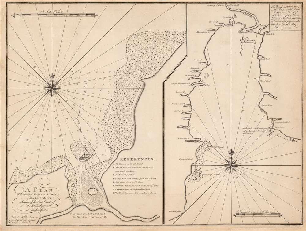

FOR THE ORIGINAL ANTIQUE MAP, WITH HISTORICAL ANALYSIS, CLICK HERE.
Digital Map Information
Geographicus maintains an archive of high-resolution rare map scans. We scan our maps at 300 DPI or higher, with newer images being 600 DPI, (either TIFF or JPEG, depending on when the scan was done) which is most cases in suitable for enlargement and printing.
Delivery
Once you purchase our digital scan service, you will receive a download link via email - usually within seconds. Digital orders are delivered as ZIP files, an industry standard file compression protocol that any computer should be able to unpack. Some of our files are very large, and can take some time to download. Most files are saved into your computer's 'Downloads' folder. All delivery is electronic. No physical product is shipped.
Credit and Scope of Use
You can use your digial image any way you want! Our digital images are unrestricted by copyright and can be used, modified, and published freely. The textual description that accompanies the original antique map is not included in the sale of digital images and remains protected by copyright. That said, we put significant care and effort into scanning and editing these maps, and we’d appreciate a credit when possible. Should you wish to credit us, please use the following credit line:
Courtesy of Geographicus Rare Antique Maps (http://www.geographicus.com).
How Large Can I Print?
In general, at 300 DPI, you should at least be able to double the size of the actual image, more so with our 600 DPI images. So, if the original was 10 x 12 inches, you can print at 20 x 24 inches, without quality loss. If your display requirements can accommodate some loss in image quality, you can make it even larger. That being said, no quality of scan will allow you to blow up at 10 x 12 inch map to wall size without significant quality loss. For more information, it is best consult a printer or reprographics specialist.
Refunds
If the high resolution image you ordered is unavailable, we will fully refund your purchase. Otherwise, digital images scans are a service, not a tangible product, and cannot be returned or refunded once the download link is used.
William Herbert (November 29, 1718 – March 18, 1795) was a British map seller, book seller, publisher, and surveyor based in London in the second half of the 18th century. Herbert was born in London, the son of a dyer and hosier of Gravel Lane. He signed on to the East India company in 1738 as a purser's clerk, traveling in the process to the colonies in India. He returned to London in about 1745, having amassed a considerable collection of manuscript plans and charts of East India ports. Recognizing their commercial value he set up business as a map and print seller on London Bridge in 1748. The premises of this business were sadly destroyed while Herbed watched the April 11, 1759 London Fire. He published a number of maps as well as the important New Directory for the East Indies. Much of his most important cartographic work seem to be associated with William Nichelson, who traveled to the East Indies in the 1750s and 60s mapping ports on behalf of the EOC. He retired in 1776 in reasonable comfort. His publications continued to be updated and re-published by his successors, among the Samuel Dunn and Henry Gregory. More by this mapmaker...
John Brohier (fl. 1746 - 1760) was a British sailor, artilleryman, engineer, fraud, and fugitive from justice. The earliest record of Brohier is a 1746 manuscript chart of the harbor of Ambodifotatra on the island of Île Sainte-Marie, Madagascar. The chart references the anchorages used by the ship Winchelsea; this was most likely the Indiaman Winchelsea, which sailed for the EIC from 1742 until its wreck in April 1749 near Fort St. David (Bombay.) Apart from this chart, the name John Brohier first appears in East India Company dispatches - also, from Fort St. David - as a mariner, being permitted to reside in India beginning in January 1750. The next appearance of John Brohier is a request for appointment of a Lieutenant John Brohier, artilleryman, as assistant to Benjamin Robins, the Engineer General of the East India Company. No sooner was this request tendered than Robins died, and Brohier was appointed to carry out Robins' work on Fort St. George. From his death-bed, Robins had advised the Council, 'The Works here will be finished by Mr. Brohier, who has full instructions from me… He is certainly the properest Person for that Work I know and I recommend him as such. He has hitherto behaved, I believe, with great integrity.' Brohier went on to become Engineer-in-charge of all British territory in India, successfully improving the defenses of Fort St. David, Fort William, and Fort St. George over the course of the 1750s. In 1760, authorities in Calcutta reported that 'great Frauds (had been committed) in carrying out the new Works…' Brohier stood accused of having diverted a large amount of the funds allotted to the construction into his pockets. Arrested but then paroled, Brohier fled from Calcutta to Sri Lanka, which at the time was Dutch territory. It is supposed that he settled there, as he vanishes from the record. Learn More...
John Spilsbury (1739 – 1769) was a British cartographer, engraver, and bookseller. He is often credited as the inventor of the jigsaw puzzle. He apprenticed to Thomas Jefferys, the Royal Geographer to King George III. Spilsbury engraved maps for Andrew Dury and a number of charts for William Herbert. Spilsbury began producing dissected maps in 1766 as an educational tool to teach geography, pasting maps down to a board and then cutting them in pieces with a jigsaw. Learn More...
Copyright © 2025 Geographicus Rare Antique Maps | Geographicus Rare Antique Maps
This copy is copyright protected.
Copyright © 2025 Geographicus Rare Antique Maps