This item has been sold, but you can get on the Waitlist to be notified if another example becomes available, or purchase a digital scan.
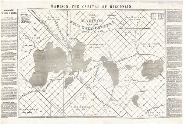
1856 Horace Greeley Broadside Map of Madison Wisconsin (first map to name Madison's 4 lakes)
madisonfourlake-greeley-1856$625.00

Title
Map of Madison and the Four Lake Country, Dane Co. Wis.
1856 (undated) 18 x 28 in (45.72 x 71.12 cm) 1 : 51000
1856 (undated) 18 x 28 in (45.72 x 71.12 cm) 1 : 51000
Description
An extremely rare 1856 broadside issued by Horace Greely and Wisconsin Governor Leonard J. Farwell promoting settlement in Madison, Wisconsin. This map is important as the first map to apply the modern names for all four of Madison's lakes. Oriented with northeast at the top, the map centers on Madison Wisconsin and is projected to illustrate that city's four exceptional lakes. Promotional text, written by Horace Greely and other notables, appears in both the right and left margins.
Farwell served as governor of Wisconsin from 1852 to 1854 during which time he did much to promote the development of Madison. Near the end of his tenure the Milwaukee & Mississippi Railroad completed its track through Madison. The arrival of the railroad instigated a period of enormous growth for the city, on which Farwell left an indelible stamp. Around this time Farwell took upon himself the task of naming the four beautiful lakes for which the city was famous. According to one historian:
We have seen several editions of this map in private and public collections. The most common lacks the promotional text to either side. One example, in the Madison Historical Society features colorful borders, but these may have been added later. The present example is the most iconic. Moreover, of all known examples, the present offering surpasses all in terms of condition. Despite a large print run, about 10,000 if Park is to be believed, this map was printed on extremely fine tissue. Few examples survive and most are in rough condition with numerous repairs. The present example, despite a few printing flaws, is in superb condition.
Farwell served as governor of Wisconsin from 1852 to 1854 during which time he did much to promote the development of Madison. Near the end of his tenure the Milwaukee & Mississippi Railroad completed its track through Madison. The arrival of the railroad instigated a period of enormous growth for the city, on which Farwell left an indelible stamp. Around this time Farwell took upon himself the task of naming the four beautiful lakes for which the city was famous. According to one historian:
Sometime in 1854, Governor Farwell, when preparing a map of Madison and the Four Lake Country, subsequently published, applied to Lyman C. Draper to aid him in determining appropriate names for each of these beautiful sheets of water …. Thus were placed upon this map of Four Lake country in 1856 of which not less than ten thousand were circulated by the liberal hearted projector, the names Ke-gon-sa, or Fish Lake; Wau-be-sa, or Swan Lake; Mo-no-na, or Fairy Lake; and Men-do-ta or Great Lake. Let these euphonious and appropriate Indian names be preserved forever! (Park, W. J. Madison, Dane County and Surrounding Towns: Being a History and Guide, page 206 – 208).Many comment on the role of Horace Greeley with relation to this map. Greeley visited Madison Wisconsin in 1854-55 to participate in the political convention that founded the Republican Party. During his visit he must have become enamored, for his praise for it is considerable, and there he become involved with Farwell's attempts to promote the city. Most scholarly sources claim that the map was printed by Horace Greeley and, although the map lack's an imprint, this is probably the case.
We have seen several editions of this map in private and public collections. The most common lacks the promotional text to either side. One example, in the Madison Historical Society features colorful borders, but these may have been added later. The present example is the most iconic. Moreover, of all known examples, the present offering surpasses all in terms of condition. Despite a large print run, about 10,000 if Park is to be believed, this map was printed on extremely fine tissue. Few examples survive and most are in rough condition with numerous repairs. The present example, despite a few printing flaws, is in superb condition.
Condition
Very good. Printed on extremely thin tissue paper. A few publication flaws due to the paper being wrinkled slightly when the document was pressed. Chip to upper margin. Minor tear upper margin. Probably the finest remaining example.
References
Boston Public Library, Leventhal Center, G4124.M2 1855 .M37. OCLC 857674048 (digital), 733954442 (Print), 166640604. Park, W. J. Madison, Dane County and Surrounding Towns: Being a History and Guide, pages 208.