1765 Bellin World Map showing Magnetic Variations
MagneticVariations-bellin-1765$1,250.00


Title
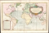
Carte des variations de la boussole et des vents généraux que l'on trouve dans les mers les plus frequentées...
1765 (dated) 21.75 x 34.5 in (55.245 x 87.63 cm) 1 : 37000000
1765 (dated) 21.75 x 34.5 in (55.245 x 87.63 cm) 1 : 37000000
Description
This is a beautiful example of J. N. Bellin's 1765 nautical chart of the world, displaying the magnetic variations measured in the Atlantic and Indian Oceans. This is the first French chart to have done so.
The observation that magnetic compasses do not point precisely north, but vary from place to place, offered the possibility that these magnetic variations could aid in determining longitude. The English - led by Edmund Halley - had made extensive studies measuring and recording magnetic variation; Halley published the first map showing isogonic lines in 1701. Further study by the Royal Society resulted in additional data in 1744, but their major determination was that magnetic variations changed constantly and that any method relying on them would be a can of worms. The French, too, followed suit, relying mainly on the data of the Royal Society as is evidenced here on the chart: a note in the lower left credits measurements of the variations to two fellows of the Royal Society, William Mountaine and James Dodson, whose updated data appeared in the 1757 Philosophical Transactions of that body.
A Closer Look
This is a partial chart of the world on the Mercator Projection: it reaches as far west as California's Cape Mendocino and as far east as the Japanese main island of Honshu and the western coasts of Australia. The chart thus ignores the Pacific Ocean, focusing instead on the Atlantic coasts of Europe, Africa, and the Americas, as well as the African, Asian, and Australian coasts of the Indian Ocean. The East Indies and Japan are also included. Since magnetic variations were considered an aid to navigation, this work is primarily a chart and does not include detail inland beyond the coastlines. Instead, curvilinear lines appear (isogoniclines, indicating areas of equal magnetic declination). Also, minute winged wind-heads are placed throughout to indicate prevailing winds.Longitude and Magnetic Variations
For centuries, one of the greatest challenges facing navigators was determining longitude at sea. Long after sailors had learned to use the position of the Sun and the stars to determine a ship's position relative to the Equator, the Earth's rotation deprived mariners of any stable reference that would practically reveal a ship's east-west position on the globe. The problem would eventually be solved in 1773 by John Harrison's invention of a marine chronometer, but prior to this, the method of using a timekeeper to calculate longitude was met with skepticism. Sir Isaac Newton did not believe that a machine of sufficient precision could be constructed, for example. Thus, other methods were approached. Referring to the position of the moon was considered a possibility, but the calculations involved in that method were prohibitively complex and time-consuming. Galileo had thought that the moons of Jupiter could be employed as a sort of astronomical marine chronometer, but the impracticalities of making such observations at sea led this method to be abandoned as well.The observation that magnetic compasses do not point precisely north, but vary from place to place, offered the possibility that these magnetic variations could aid in determining longitude. The English - led by Edmund Halley - had made extensive studies measuring and recording magnetic variation; Halley published the first map showing isogonic lines in 1701. Further study by the Royal Society resulted in additional data in 1744, but their major determination was that magnetic variations changed constantly and that any method relying on them would be a can of worms. The French, too, followed suit, relying mainly on the data of the Royal Society as is evidenced here on the chart: a note in the lower left credits measurements of the variations to two fellows of the Royal Society, William Mountaine and James Dodson, whose updated data appeared in the 1757 Philosophical Transactions of that body.
Publication History and Census
Bellin's chart was engraved in 1765 for inclusion in Bellin's Hydrographie Françoise. Twenty examples of the book are listed in OCLC; 16 examples of the chart are cataloged in institutional collections.Cartographer
Jacques-Nicolas Bellin (1703 - March 21, 1772) was one of the most important cartographers of the 18th century. With a career spanning some 50 years, Bellin is best understood as geographe de cabinet and transitional mapmaker spanning the gap between 18th and early-19th century cartographic styles. His long career as Hydrographer and Ingénieur Hydrographe at the French Dépôt des cartes et plans de la Marine resulted in hundreds of high quality nautical charts of practically everywhere in the world. A true child of the Enlightenment Era, Bellin's work focuses on function and accuracy tending in the process to be less decorative than the earlier 17th and 18th century cartographic work. Unlike many of his contemporaries, Bellin was always careful to cite his references and his scholarly corpus consists of over 1400 articles on geography prepared for Diderot's Encyclopedie. Bellin, despite his extraordinary success, may not have enjoyed his work, which is described as "long, unpleasant, and hard." In addition to numerous maps and charts published during his lifetime, many of Bellin's maps were updated (or not) and published posthumously. He was succeeded as Ingénieur Hydrographe by his student, also a prolific and influential cartographer, Rigobert Bonne. More by this mapmaker...
Source
Bellin, N., Hydrographie Françoise, (Paris: Depot de la Marine) 1765.
Condition
Very good. Few filled wormholes with minimal loss. Overall a bright example with elegant hand color.
References
OCLC 50753462. Rumsey 12059.081.