This item has been sold, but you can get on the Waitlist to be notified if another example becomes available, or purchase a digital scan.
1823 Coste Folding Map of the Mahmudiyya Canal, Egypt
MahmudiyyaCanal-coste-1823$700.00

Title
Plan du Nouveau Canal d'Alexandrie dit Mahmoudyeh.
1823 (undated) 15 x 19.75 in (38.1 x 50.165 cm) 1 : 153000
1823 (undated) 15 x 19.75 in (38.1 x 50.165 cm) 1 : 153000
Description
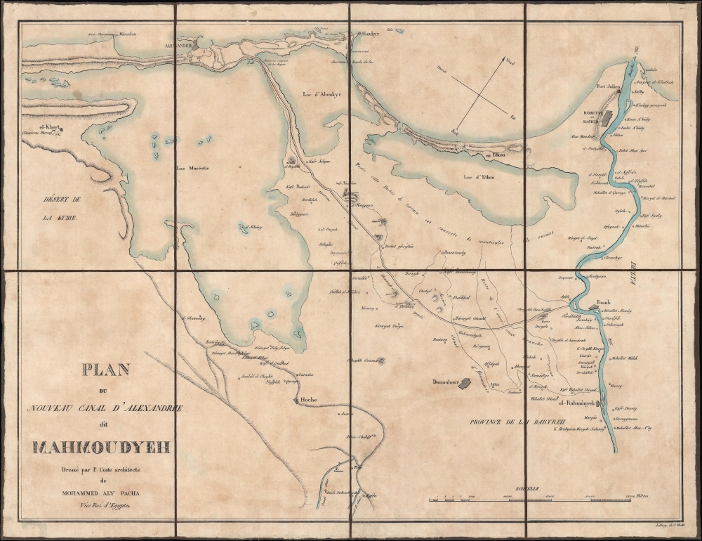
A scarce c. 1823 separately-issued folding map of Mahmudiyya Canal near Alexandria, Egypt, by Pascal Coste. The canal was one of several key infrastructure projects launched by Muhammad Ali Pasha.
A Closer Look
Oriented towards the northwest, this map displays the region around Alexandria, which sits on the Mediterranean coast. The canal under focus (still extant) is the line running diagonally across the map ('Nouveau canal d'Alexandrie appelé Mahmoudyéh'), including over a dike between two lakes. The more noticeable blue waterway at right is the Nile. Aside from the canal, the Nile, and additional canals at the bottom, cities, villages, forts, trails, lakes, ruins, and other features are labeled. Rashid or Rosetta at top-right, at the mouth of the Nile, is perhaps best known as being the site where, in 1799, Napoleon's troops discovered the Rosetta Stone. Afterward, there was a burst of European interest in Egypt, including the work in which this map originally appeared.The Mahmudiyya Canal(s)
Designed to bring fresh water from the Nile to Alexandria, similar canals had existed in Antiquity and the Medieval Period; therefore, the project could be deemed a reconstruction, though the earlier canals had long been subsumed by the desert. Coste did not plan the canal, as he only arrived in Egypt several months after construction had begun. But, in his later role as chief engineer for Lower (that is, northern) Egypt, he would have been involved in its maintenance, a difficult task given the propensity of the canal to fill with sand. Already by the 1850s, it had become unnavigable to boats and had to be cleared. The canal continued to be an essential source of water and transportation infrastructure well into the 20th century. However, in the 1950s, a new group of modernizers blocked one end of the canal for an industrial project, leading to its becoming heavily polluted and neglected for decades. More recently, proposals have been floated to beautify the canal and revive it for recreational and tourist purposes.Alexandria in the Early 19th Century
By the early 19th century, Alexandria had long lost the magnificence it maintained in Antiquity but remained an important port for Mediterranean trade. The city was damaged during the French intervention and resulting conflict, including a British Siege, which ended with a British victory in March 1801. Being a modernizer with grand ambitions, Muhammad Ali aimed to restore the city to its former splendor. He was also partial to Alexandria because his rise to power had been aided by a successful military campaign against the British near the city in 1807, which made him a popular hero. By 1830, Muhammad Ali's policies had led to a population boom in Alexandria (facilitated partly by the canal), a new urban plan, and a range of grand new buildings influenced by contemporary European architectural styles.Egypt's Ambitious Pasha
Muhammad Ali Pasha initially came to power in Egypt after being dispatched by the Ottomans to restore their authority there, which had been overturned by Napoleon's invasion in 1798 and a subsequent civil war. However, and not for the first time in Ottoman history, a dynamic administrator and capable military commander proved to be a double-edged sword. Muhammad Ali successfully pacified Egypt but immediately moved to assert his autonomy and instituted a range of modernizing reforms, including infrastructure projects such as those seen here. Until he was debilitated by age and disease in the late 1840s, the pasha was alternatively a great asset for the sultan - conquering Sudan, reconquering Arabia, and nearly reconquering Greece in the 1820s - before threatening to topple the Sublime Porte itself in the 1830s, which was only prevented by the intervention of European powers to preserve the status quo. Although the Khedivate established de facto independence from the Ottomans and undertook important reforms, its ambitious momentum of the early 19th century could not be sustained as the pasha aged and power passed to successors. Eventually, Egypt and associated territories fell under British occupation and a protectorate, which lasted until the post-World War II period.Publication History and Census
This map was prepared by Pascal Coste and lithographed by Charles Motte. It originally appeared in a supplemental atlas to Félix Mengin's 1823 book Histoire de l'Égypte sous le gouvernement de Mohammed-Aly…. The map is only independently cataloged among the holdings of the Staats- und Universitätsbibliothek Göttingen.CartographerS
Xavier Pascal Coste (November 26, 1787 - February 8, 1879) was a French engineer and architect with a distinguished career in France, North Africa, and the Middle East. Born in Marseilles, Coste showed artistic promise from a young age and studied in the studio of architect Michel-Robert Penchaud (1772 - 1833). In 1814, he entered into the École des Beaux-Arts, where a friend connected him to Muhammad Ali Pasha, the Ottoman viceroy of Egypt, who took Coste as his personal architect in 1817. Coste would spend most of the next twelve years in Egypt, where the pasha designated him the chief engineer of Lower Egypt. He also published several scholarly works, including a well-received overview of Arab architecture. After returning to France for health reasons in 1829, Coste became a professor of architecture at the École des Beaux-Arts, where he had a long and distinguished career. He was known for a long trip through Persia with painter Eugène Flandin (1809 - 1889). In 1844, he was appointed chief architect of Marseilles. Coste's reputation was such that he was made an officer of the Légion d'honneur shortly before his death. More by this mapmaker...
Charles Etienne Pierre Motte (November 2, 1785 - December 5, 1836) was a French lithographer, etcher, and draughtsman based in Paris and London. Little is known of his life and training, but he began operations around 1818 in Paris. In the late 1820s, he worked closely with the printer and published J. P. Quénot. Around 1830, Motte opened a London branch, which was sold or otherwise passed on to engraver and printer Alfred Ducôte. In the early 1830s, when his career seems to have peaked, he was listed as a 'éditeur lithographe du roi.' Learn More...
Source
Mengin, F., Histoire de l'Egypte sous le gouvernement de Mohammed-Aly..., (Paris: Arthus Bertrand) 1823.
Condition
Very good. Dissected and laid on linen. Light soiling.