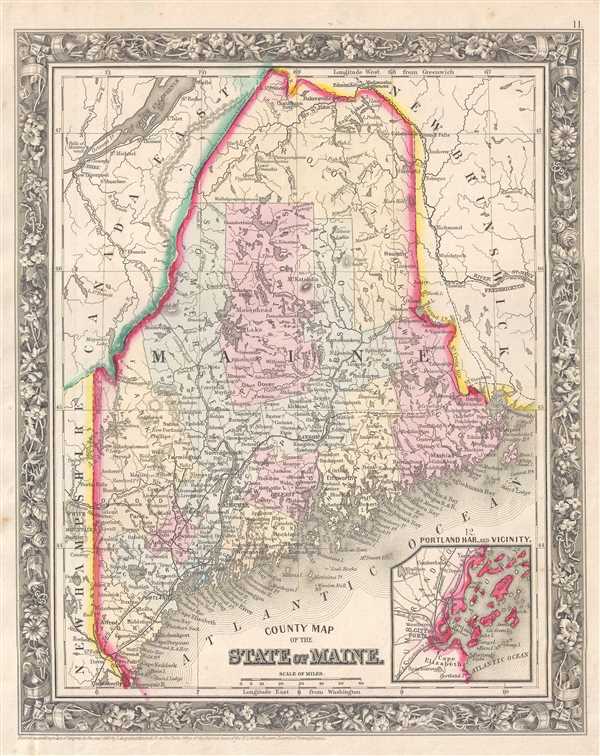
This is an 1861 Samuel Augustus Mitchell, Jr. map of Maine. The map depicts the region from New Hampshire to New Brunswick and from Quebec, Maine, and New Brunswick to the Atlantic Ocean. A handful of railroads are also illustrated and labeled. One such railroad is the York and Cumberland, which operated from 1846 until 1865 and was reorganized as the Portland and Rochester Railroad, a branch line of the Boston and Maine Railroad, in 1867. Another, the Portland, Saco, and Portsmouth Railroad, began operations in 1842, and was jointly operated by the Boston and Maine Railroad and the Eastern Railroad, which shared the track for their operations between Portland and Boston. In 1872 the Portland, Saco, and Portsmouth was purchased by the Eastern Railroad, which, in turn, was bought by the Boston and Maine in 1884. Today, portions of the route have been converted into a rail trail known as the Eastern Trail. The projected route of the European and North American Railway between Nova Scotia and Portland, Maine is illustrated by a dashed line, indicating that it had not yet been completed. Apart from the railroads, individual counties are illustrated, labeled, and shaded different colors to allow for easy differentiation. Cities, towns, and villages are labeled throughout, including Portland, Augusta, and Bangor, along with rivers, creeks, and lakes. An inset map in the lower right corner depicts the vicinity of Portland Harbor, the coast of Maine from Yarmouth to Cape Elizabeth. Roads, railroads, and even individual streets in Portland are illustrated, along with numerous islands in Casco Bay. The whole is surrounded by the attractive floral border common to Mitchell atlases between 1860 and 1865.
This map was prepared by S. A. Mitchell Jr. for inclusion in the 1861 edition of Mitchell's New General Atlas. Like many American map publishers of this period, Mitchell did not regularly update his copyrights, consequently this map is dated and copyrighted to 1860: 'Entered according to Act of Congress in the Year 1860 by S. Augustus Mitchell Jr. in the Clerk's Office of the District Court of the U.S. for the Eastern District of Pennsylvania.'
Cartographer
Samuel Augustus Mitchell (March 20, 1792 - December 20, 1868) began his map publishing career in the early 1830s. Mitchell was born in Bristol, Connecticut. He relocated to Philadelphia in 1821. Having worked as a school teacher and a geographical writer, Mitchell was frustrated with the low quality and inaccuracy of school texts of the period. His first maps were an attempt to rectify this problem. In the next 20 years Mitchell would become the most prominent American map publisher of the mid-19th century. Mitchell worked with prominent engravers J. H. Young, H. S. Tanner, and H. N. Burroughs before attaining the full copyright on his maps in 1847. In 1849 Mitchell either partnered with or sold his plates to Thomas, Cowperthwait and Company who continued to publish the Mitchell's Universal Atlas. By about 1856 most of the Mitchell plates and copyrights were acquired by Charles Desilver who continued to publish the maps, many with modified borders and color schemes, until Mitchell's son, Samuel Augustus Mitchell Junior, entered the picture. In 1859, S.A. Mitchell Jr. purchased most of the plates back from Desilver and introduced his own floral motif border. From 1860 on, he published his own editions of the New General Atlas. The younger Mitchell became as prominent as his father, publishing maps and atlases until 1887, when most of the copyrights were again sold and the Mitchell firm closed its doors for the final time. More by this mapmaker...
Source
Mitchell, S. A., Mitchell's New General Atlas Containing Maps of the Various Countries of the World, Plans of Cities, Etc., embraced in Forty-Seven Quarto Maps, Forming a series of Seventy-Six Maps and Plans, together with Valuable Statistical Tables (Philadelphia: S. Augustus Mitchell, Jr.) 1861.
Mitchell's New General Atlas was published by Samuel Augustus Mitchell, Jr., the son of the prolific cartographer Samuel Augustus Mitchell. Many of the plates are derived from the his father's Mitchell's Universal Atlas, but not directly. The Mitchell's Universal Atlas was initially sold to Thomas, Cowperthwait, and Company in 1849, and again to Charles Deliver in 1856. It was Deliver who introduced the new vibrant color scheme, abandoning the older Mitchell's Universal Atlas green borders and themes for bright reds, blues, and yellows. Samuel Augustus Mitchell, Jr. acquired the Deliver plates in 1859. He added his own floral motif border, but doubled down on the vibrant color scheme, thus introducing to the American public the most vividly colored American atlas of the 19th century. In 1860, he published the first edition of his New General Atlas and, despite a slump in sales during the American Civil War, attained a level of success to rival his father. Mitchell would continue to publish the New General Atlas until 1887, when the firm formally closed.
Very good. Even overall toning. Blank on verso.
Rumsey 0565.008 (1860 edition).