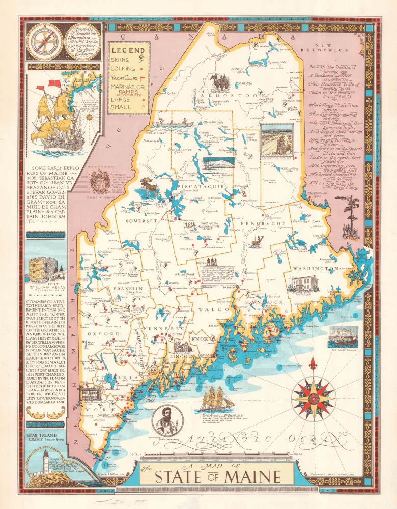
1946 / 1963 Luther S. Phillips Pictorial Map of Maine
Maine-phillips-1963
Title
1963 (dated) 23 x 17.5 in (58.42 x 44.45 cm) 1 : 950000
Description
A Closer Look
Coverage embrades the state of Maine. Pictorial vignettes highlight the Kavanagh House in Damariscotta Mills, the John Holmes House in Alfred, and the Ruggles House in Columbia Falls. Maine's wildlife also takes center stage, with illustrations of a moose, a deer, and a black bear. Maine's many ski areas are marked by skier icons, while red dots identify golf courses. Flags note yacht clubs and triangles identify large and small marinas. A poem appears in the upper left, while a list of early Maine explorers occupies the left border.Publication History and Census
This map was first drawn and published by Luther S. Phillips in 1946. His younger brother, Augustus 'Gus' D. Phillips, published this second edition in 1963 - present map. A third edition was published in 1980 by A. D. Phillips and Son. We are not aware of a cataloged example of the 1946 edition, but have seen one other example of this 1963 edition.CartographerS
Augustus Dewey Phillips (May 6, 1898 - December 14, 1975), a.k.a. 'Gus', was an American artist, cartographer, and publisher. Born on Mount Desert Island, Maine, as a boy Augustus and his brother Luther Savage Phillips (1891 - 1960) helped their dad in a variety of odd jobs, including maintaining a boat rental business and harvesting and selling ice. Augustus graduated from Hebron Academy and then attended the University of Maine for a short time. After leaving university, Phillips became a Maine Guide and worked as a carpenter and draftsman in the South Portland and Boothbay Harbor ship and boat yards. The brothers traveled together widely throughout Maine. Luther went on to start a popular map and postcard business out of Northeast Harbor, Maine. After Luther died in 1960, Augustus took over the map businesses. In a tragic turn of events, in 1973 an out of control bush fire destroyed the Phillips studio and much of the surviving stock, making all Phillips' maps issued prior to that date rare. His passion for landscapes helped Augustus create his own map style. Augustus expanded the business and continued making new maps until he died in 1975. Augustus' son, Donald Beekman Phillips (1935 - 2009) continued the business after his father's death. Augustus married Mary Fletcher on April 26, 1922, with whom he had four children. More by this mapmaker...
Luther Savage Phillips (May 10, 1891 - 1960) was an American map maker, photographer, architect, and postcard publisher, and is arguably Maine's most significant pictorial cartographer. Born on Mount Desert Island (Acadia National Park), Maine, Phillips studied at Phillips Andover Academy before spending two years at Yale. He graduated with a Bachelor of Science degree from MIT in 1914. In October 1917 Phillips enlisted in the U.S. Navy as a Coxswain and was commissioned as an Ensign in 1918, when he was sent to the U.S. Naval Academy at Annapolis, Maryland. He was later assigned to the U.S.S. Rhode Island and sailed with the ship on a mission to Archangel on April 11, 1919. After his time in the Navy, Phillips established a successful postcard publishing business and became a well-known pictorial mapmaker. Much of his work focused on the Maine coast in the vicinity of Bar Harbor. Based in Northeast Harbor, Mount Desert Island, Maine, his company, 'Map of Maine' produced local pictorial maps for the tourist market. He would tour the state promoting and selling his work, along with his scenic postcards. After Phillips died in 1960, in Togus, Maine, his brother, Augustus 'Gus' Dewey Phillips (1898 - 1975) took over the map and postcard business, which was then continued by his nephew Donald Phillips (1935 - 2009). In a tragic turn of events, in 1973 an out of control bush fire destroyed the Phillips studio and much of the surviving stock, making all Phillips' maps issued prior to that date rare. Philipps married Olympia Meimari on March 24, 1921 in Annapolis. It is unclear whether Olympia died or the couple divorced, but it is known that Phillips remarried, to Mary J. Merrill in 1935. Learn More...

