This copy is copyright protected.
Copyright © 2025 Geographicus Rare Antique Maps
Digital Image: 1868 Rogers Map of Manhattan, New York City (North of 86th Street)
ManhattanHarlemHeights-rogers-1868_d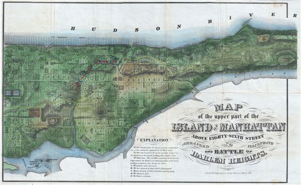

FOR THE ORIGINAL ANTIQUE MAP, WITH HISTORICAL ANALYSIS, CLICK HERE.
Digital Map Information
Geographicus maintains an archive of high-resolution rare map scans. We scan our maps at 300 DPI or higher, with newer images being 600 DPI, (either TIFF or JPEG, depending on when the scan was done) which is most cases in suitable for enlargement and printing.
Delivery
Once you purchase our digital scan service, you will receive a download link via email - usually within seconds. Digital orders are delivered as ZIP files, an industry standard file compression protocol that any computer should be able to unpack. Some of our files are very large, and can take some time to download. Most files are saved into your computer's 'Downloads' folder. All delivery is electronic. No physical product is shipped.
Credit and Scope of Use
You can use your digial image any way you want! Our digital images are unrestricted by copyright and can be used, modified, and published freely. The textual description that accompanies the original antique map is not included in the sale of digital images and remains protected by copyright. That said, we put significant care and effort into scanning and editing these maps, and we’d appreciate a credit when possible. Should you wish to credit us, please use the following credit line:
Courtesy of Geographicus Rare Antique Maps (http://www.geographicus.com).
How Large Can I Print?
In general, at 300 DPI, you should at least be able to double the size of the actual image, more so with our 600 DPI images. So, if the original was 10 x 12 inches, you can print at 20 x 24 inches, without quality loss. If your display requirements can accommodate some loss in image quality, you can make it even larger. That being said, no quality of scan will allow you to blow up at 10 x 12 inch map to wall size without significant quality loss. For more information, it is best consult a printer or reprographics specialist.
Refunds
If the high resolution image you ordered is unavailable, we will fully refund your purchase. Otherwise, digital images scans are a service, not a tangible product, and cannot be returned or refunded once the download link is used.
Joseph Shannon (fl. c. 1850 - 1869) produced a series of New York City almanacs and fact books entitled Manual of the Corporation of the City of New York. Shannon's Manual is very similar to the more common manual issued by David T. (Thomas) Valentine (1801 - 1869). The production of this annual manual was the responsibility of the Clerk of the Common Council of the City of New York, a position held at different times by both Shannon and Valentine. The manual included facts about the City of New York, City Council information, history, and reported on the progress of public works such as Central Park. More by this mapmaker...
William C. Rogers (fl. c. 1860 - 1873) was a New York based lithographer active in the mid to late 19th century. His is best known for his engravings issued in conjunction with Joseph Shannon's Manual of the Corporation fo the City of New York. Rogers issued several maps of New York City in the 1860s and 1870s. Learn More...
Copyright © 2025 Geographicus Rare Antique Maps | Geographicus Rare Antique Maps
This copy is copyright protected.
Copyright © 2025 Geographicus Rare Antique Maps