This item has been sold, but you can get on the Waitlist to be notified if another example becomes available, or purchase a digital scan.
1890 Immigration Map of Manhattan, New York City
ManhattanNationalities-norrispeters-1890$600.00

Title
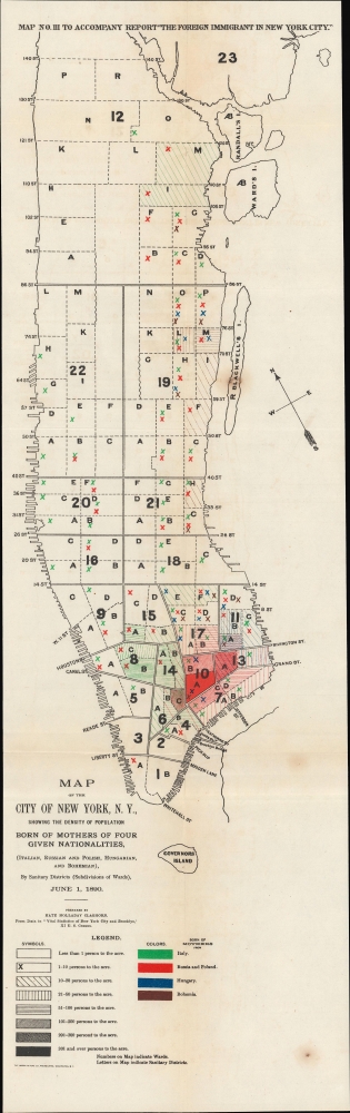
Map of the City of New York, N.Y., showing the Density of Population Born of Mothers of Four Given Nationalities, (Italian, Russian and Polish, Hungarian, and Bohemian)
1890 (dated) 24.75 x 7.5 in (62.865 x 19.05 cm) 1 : 30000
1890 (dated) 24.75 x 7.5 in (62.865 x 19.05 cm) 1 : 30000
Description
An early work of sociological cartography, this 1890 map of New York City was prepared by Kate Holladay Claghorn and published as a supplement to the 1901 government report 'The Foreign Immigrant in New York City.' It displays the population density of four European ethnic groups in Manhattan, demonstrating their concentration in Lower Manhattan.
A Closer Look
Displaying most of the island of Manhattan, divided and numbered into wards, black x's and shading are used to indicate the density of immigrant populations, while coloration highlights the national origin of the immigrant groups: Italian (green), Russians and Poles (red), Hungarians (blue), and Bohemians (brown). Though not indicated separately, many of the non-Italian immigrants included here would have been Jewish. Overall, there are pockets of these immigrant communities throughout Manhattan, aside from the Upper West Side, with a particularly dense concentration in Lower Manhattan around Houston and Canal, in the Lower East Side, and the East Village.Publication History and Census
Though using data from 1890, this map was the third of four maps prepared by Kate Holladay Claghorn to accompany the 1901 report, 'The Foreign Immigrant in New York City,' published in Reports of the Industrial Commission, Vol. 15 (the Industrial Commission was a short-lived advisory body established by President McKinley). The maps are scarcer than the report and are cataloged only at the New York Public Library.CartographerS
Kate Holladay Claghorn (c. 1864 - May 22, 1938) was an American sociologist, scholar, and activist of the Progressive Era. Born in Illinois, Claghorn grew up in New York City, attending Bryn Mawr and then attaining a PhD from Yale University, one of the first women to do so, focusing her research at the intersection of economics, political science, history, and anthropology. She worked several jobs with the U.S. government before joining the New York Tenement House Department, establishing herself as an expert on immigration and statistics. In 1912, she took a teaching position and became head of the Department of Social Research at the New York School of Applied Philanthropy. Throughout her career, Claghorn was an advocate for the rights of immigrants, African-Americans, and women. More by this mapmaker...
Norris Peters (c. 1834 – July 15, 1889) was a Washington D.C. based photo-lithographer active in the late 18th and early 19th century whom Scientific American called 'one of Washington's most eccentric and mysterious figures.' Peters was born and educated in Pennsylvania. He relocated as a young man to Washington D.C. where he took work as an examiner for the United States Patent Office. During his work with the patent office he became fascinated with the emergent process of photolithography. In 1869 Peters secured substantial venture capital of about 100,000 USD from an unknown investor and founded The Norris Peters Company at 458 Pennsylvania Avenue. Their printing offices have been described as 'unequaled in this or any other country.' From these offices Peters pioneered the development of American photo-lithography. For nearly a generation he held a near monopoly on government photo-lithographic printing. Among their more notable contracts included numerous maps for congressional reports, maps of the U.S. Coast Survey, maps of the U.S. Geological Survey, Mexican currency for the State of Chihuahua, and the Official Gazette of the Patent Office. Peters also maintained an interesting social life and was a confidant to many of the most powerful figures in Congress. He was also a bon vivant known for being an excellent cook and hosting lavish dinners, the invitations to which were 'never declined'. Despite being socially active he never married and died a confirmed bachelor. Following Peters' death in 1889 his business was taken over by Henry Van Arsdale Parsell who administered it until his own death in 1901. The company then merged with Webb & Borcorselski, another D.C. lithography firm, and was renamed Webb & Borcorselski-Norris Peters. They continued to publish under this name well into the mid 20th century. Learn More...
Source
Map[s] to accompany report The Foreign Immigrant in New York City.
Condition
Very good. Light wear along original folds. Some foxing.
References
OCLC 42916738.