Digital Image: 1787 Jaugeon / Desnos Wall Map of the World in Hemispheres
MappeMonde-desnos-1786_d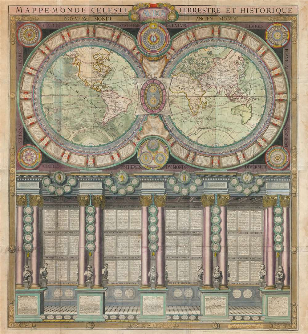

Title
Mappe-Monde Celeste Terrestre et Historique.
1786 (dated) 42.5 x 39 in (107.95 x 99.06 cm) 1 : 35000000
1786 (dated) 42.5 x 39 in (107.95 x 99.06 cm) 1 : 35000000
Description
FOR THE ORIGINAL ANTIQUE MAP, WITH HISTORICAL ANALYSIS, CLICK HERE.
Digital Map Information
Geographicus maintains an archive of high-resolution rare map scans. We scan our maps at 300 DPI or higher, with newer images being 600 DPI, (either TIFF or JPEG, depending on when the scan was done) which is most cases in suitable for enlargement and printing.
Delivery
Once you purchase our digital scan service, you will receive a download link via email - usually within seconds. Digital orders are delivered as ZIP files, an industry standard file compression protocol that any computer should be able to unpack. Some of our files are very large, and can take some time to download. Most files are saved into your computer's 'Downloads' folder. All delivery is electronic. No physical product is shipped.
Credit and Scope of Use
You can use your digial image any way you want! Our digital images are unrestricted by copyright and can be used, modified, and published freely. The textual description that accompanies the original antique map is not included in the sale of digital images and remains protected by copyright. That said, we put significant care and effort into scanning and editing these maps, and we’d appreciate a credit when possible. Should you wish to credit us, please use the following credit line:
Courtesy of Geographicus Rare Antique Maps (http://www.geographicus.com).
How Large Can I Print?
In general, at 300 DPI, you should at least be able to double the size of the actual image, more so with our 600 DPI images. So, if the original was 10 x 12 inches, you can print at 20 x 24 inches, without quality loss. If your display requirements can accommodate some loss in image quality, you can make it even larger. That being said, no quality of scan will allow you to blow up at 10 x 12 inch map to wall size without significant quality loss. For more information, it is best consult a printer or reprographics specialist.
Refunds
If the high resolution image you ordered is unavailable, we will fully refund your purchase. Otherwise, digital images scans are a service, not a tangible product, and cannot be returned or refunded once the download link is used.
Cartographer S
Nicolas Jaugeon (fl. c. 1680 - 1710) was a typographer, mathematician, and engraver active in Paris in the late 17th and early 18th centuries. Jaugeon is best known for the 1692 invention of the typeface Romain du Roi, which is best known today as Times New Roman. The typeface was revolutionary at the time as it abandoned the artistic principles of calligraphy to instead draft each letter on a uniform mathematical platform. The typeface was initially reserved for the French Royal Press, Imprimerie Royale, but was later adopted by others. Jaugeon was also a prominent and active member of the French Academy of Sciences. He cartographic corpus appears limited to a single, but spectacular, map of the work published in 1688. Another Jaugeon, Jacques, also appears to be associated with the development of Romain du Roi, and the two are often conflated as the same individual, suggesting further research into the elusive but important individual is required. More by this mapmaker...
Louis Charles Desnos (1725 - April 18, 1805) was an important 18th century instrument maker, cartographer and globe maker based in Paris, France. Desnos was born in Pont-Sainte-Maxence, Oise, France, the son of a cloth merchant. From April of 1745 he apprenticed at a metal foundry. Desnos married the widow of Nicolas Hardy, sone of the map, globe, and instrument seller Jacques Hardy. Desnos held the coveted position of Royal Globemaker to the King of Denmark, Christian VII, for which he received a stipend of 500 Livres annually. In return Desnos sent the King roughly 200 Livres worth of maps, books and atlases each year. As a publisher, Desnos produced a substantial corpus of work and is often associated with Zannoni and Louis Brion de la Tour (1756-1823). Despite or perhaps because of the sheer quantity of maps Desnos published he acquired a poor reputation among serious cartographic experts, who considered him undiscerning and unscrupulous regarding what he would and would not publish. Desnos consequently had a long history of legal battles with other Parisian cartographers and publishers of the period. It is said that he published everything set before him without regard to accuracy, veracity, or copyright law. Desnos maintained offices on Rue St. Jacques, Paris. Learn More...
Louis Brion de la Tour (1743 - 1803) was the Cartographer Royal to the King of France, his official title being Ingenieur-Geographe du Roi. Despite a prolific cartographic career and several important atlases to his name, little is actually known of his life and career. He may have been born in Bordeaux. His son of the same name was born in 1763 and published until his death in 1832. It is nearly impossible to distinguish the work of the father from the work of the son, as both used the same imprint and were active in roughly the same period. Much of their work was published in partnership Louis Charles Desnos (fl. 1750 - 1790). Their most notable work is generally regarded to be his 1766 Atlas General. Learn More...
Albert Jouvin de Rochefort (c. 1640 - c. 1710) was a French cartographer and government official active during the second half of the 17th century. Rochefort is a little known figure who served as Treasure to the King of France at Limoges from 1675 to 1702. In this capacity he traveled extensively throughout France and Europe in General, publishing an account of his travels with the firm of Thierry, Louis and Claude Barbin Billain. He apparently also traveled extensively in Egypt, the Holy Land, and Turkey. He produced several important maps, most of which are on a massive scale, to illustrate his cardinal work, Le voyageur d'Europe, où sont les voyages de France, d'Italie et de Malthe, d'Espagne et de Portugal, des Pays Bas, d'Allemagne et de Pologne, d'Angleterre, de Danemark et de Suède. In 1672-5 Rochefort issued a monumental plan of Paris in nine panels, Paris et ses Environs followed by a smaller plan in 1697, Nouveau plan de Paris. Apparently a portrait of Rochefort is preserved in the National Library of France. Learn More...
References
Shirley, Rodney W., The Mapping of the World: Early Printed World Maps 1472-1700, #538. OCLC 962041678.