1897 Le Petit Journal Double Hemisphere Wall Map w/ World's Ethnicities
Mappemonde-lepetitjournal-1897$1,400.00


Title
Mappemonde dressée et grave spécialement pour le Petit Journal d’après les documents le plus récents…
1897 (undated) 37 x 43 in (93.98 x 109.22 cm) 1 : 25000000
1897 (undated) 37 x 43 in (93.98 x 109.22 cm) 1 : 25000000
Description
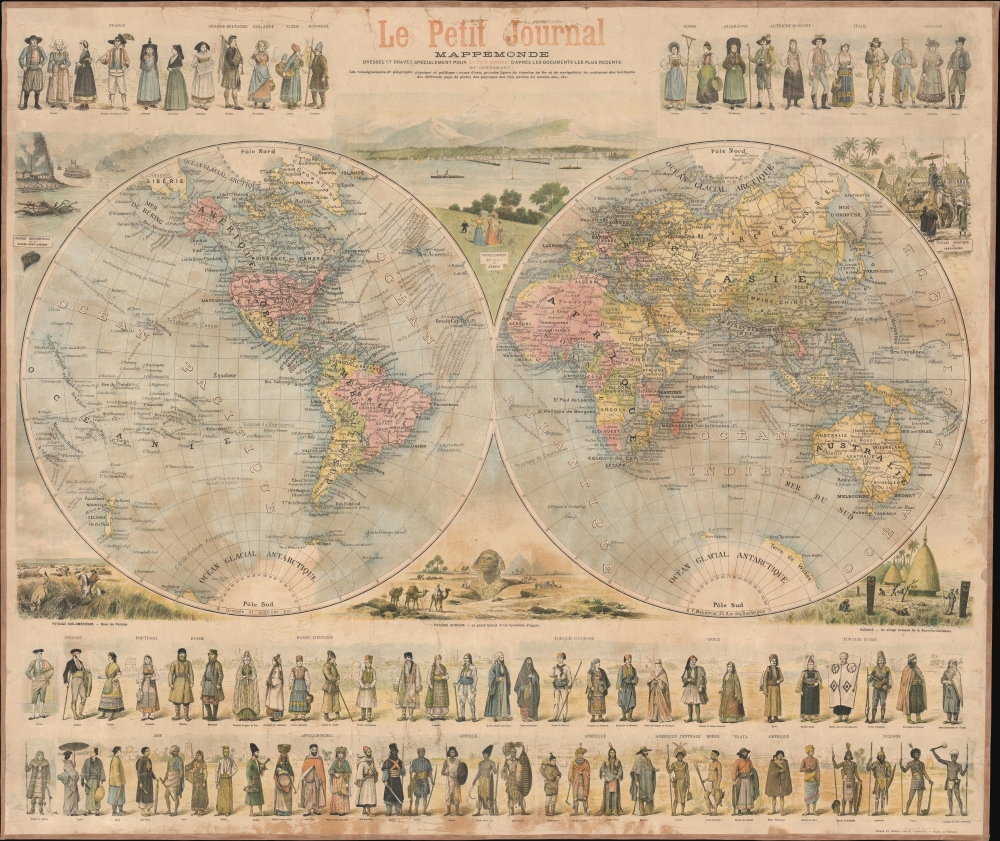
A superb c. 1897 wall map of the world in two hemispheres printed by Emil Charaire for Le Petit Journal, the largest newspaper in the world at the time. Among other interesting features, the map is surrounded by figures in ethnic dress representing the peoples of the world.
Despite the wide circulation of Le Petit Journal at the time, this wall map is now quite scarce, with examples noted in the OCLC at the National Library of Australia and Biblioteca Nacional de Chile, while an example is also held by the David Rumsey Historical Map Collection, which dates it to 1880.
A Closer Look
The world is displayed in a double hemispheric projection, with countries and colonies color-shaded. Cities, major waterways, railways, shipping routes (and times) between major ports, and other features are noted throughout. Vignettes surround the map, depicting views (paysages) of the Saint Lawrence River, the Lake of Geneva, a scene involving an elephant and stupa in Indochina, a village in New Caledonia, the Sphinx and pyramids in Egypt, and the Pampas in South America. At the top and bottom, 84 figures represent the peoples of the world, with distinctive ethnic dress.Publication History and Census
This sheet was prepared as a supplement to Le Petit Journal. The double hemisphere map was drawn and designed by the Imprimerie de F. Menetrier, while the entire sheet was printed by the Imprimerie Emile Charaire. It is undated, but the map is referenced in a November 1897 issue of Le Petit Journal, meant to be an enlargement and embellishment of a map that had appeared in the paper earlier that year. Other features, such as the configuration of European colonies in Africa and Asia, a reference to the 1895 North Polar Explorations of Nansen, and the completion of the Trans-Siberian Railway (including the planned though not yet constructed Circum-Baikal Railway), support a date in the late 1890s.Despite the wide circulation of Le Petit Journal at the time, this wall map is now quite scarce, with examples noted in the OCLC at the National Library of Australia and Biblioteca Nacional de Chile, while an example is also held by the David Rumsey Historical Map Collection, which dates it to 1880.
CartographerS
Le Petit Journal (1863 - 1944) was one of the major French daily newspapers of the French Third Republic era or Belle Époque in the late 19th and early 20th century. Founded by Moïse Polydore Millaud, the paper quickly established itself as a major player in French journalism, and was the largest French daily within two years and effectively dominated the daily press of the late 19th century, thanks in part to the use of advanced printing technology (rotary presses). In 1884, the paper introduced the Supplément illustré on Sundays, the first of its sort to include color illustrations. By the end of the 19th century, it was the largest newspaper in the world, with a daily circulation of roughly 2 million. However, the paper was badly damaged by its conservative bent through the drama of the Dreyfus Affair. Editor Ernest Judet was a staunch anti-Dreyfusard, even as facts increasingly made that position untenable. As a result, Le Petit Parisien replaced Le Petit Journal, and the latter's circulation dropped off considerably. It maintained a niche audience, however, especially among supporters of the right-wing Croix-de-Feu and later the French National Party. More by this mapmaker...
The Imprimerie Charaire (1872 - 1972) was a printing firm in Sceaux, France, and was active for about a century. Bought on August 1, 1872, by Michel Charaire (March 8, 1818 - 1907), the Imprimerie Charaire became the largest employ in Sceaux (then a town of 5,000 inhabitants south of Paris). Charaire's son Émile (1843 - 1902) worked alongside his father, helping the printing firm succeed. By 1900, it was the ninth-largest printing house in France by number of publications. The Charaires bought modern rotating printing presses which allowed them to increase their production to nearly 80,000 sheets a day. The Charaires insisted on treating their employees well (although they only paid them 4.35 Francs a day while a comparable job in Paris might pay as much as ten francs a day). The Charaires also improved life around town and treated their employees well. During their time as the owners of the print shop, the Charaire's workers on went on strike once and it lasted only three hours. The Sociéte Parisienne d'édition, founded by the Offenstadt brothers, bought the Imprimerie Charaire in 1923. The Offenstadt family had the firm taken from them during World War II due to their Jewish heritage and it published several pro-Hitler pieces during the Occupation. After the Liberation, it is unclear of the Offenstadt family regained the firm or not. The printing house was absorbed by the Ventillard publishing house at the end of the 1960s and gradually declined until it was finally closed in 1972. Learn More...
Imprimerie de F. Menetrier (c. 1872 - 1900) was a publisher, primarily of maps, based in Paris. Little is known about the firm, though it was quite active in the map publishing world in the 1880s and 1890s. Its earliest known work was a large and ambitious Atlas National de France in 1872. Afterwards, it primarily published maps of European countries and their colonial possessions, as well as world maps. The firm should not be confused with the illustrator Ferdinand-Léon Ménétrier (1859 - 1880), nor the early 20th century Spanish-French translator Félix Ménétrier. Learn More...
Condition
Good. Laid down on fresh linen. Some soiling and cracking.
References
OCLC 222149509, 662516247. Rumsey 10477.000.